Objectives of the service

Image credit: neXat, and Seafar Project :SeaNext
Remote monitoring and control of ships, notably navigating in coastal area, is not performed in a full scale and that is due to:
-
Lack of a shore control center and control systems onboard to control the ship
-
Communication limitation from sea to shore and other way around
-
Lack of accurate position estimation in certain areas such as under bridges for losing GNSS high-quality signals.
-
Safety issues in cross-border navigation.
The limitations in communication between the vessel in coastal area and shore control center as well as providing situation awareness to remote captains can be addressed by utilization of space assets.
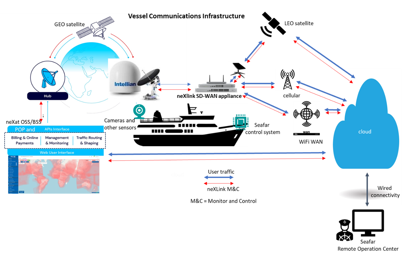
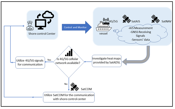
Considering the above mentioned constraints, the overall objective of SeaNext is to provide uninterrupted and fast connection between the vessel and remote operation center for a successful semi-autonomous sailing of the vessel. In this service, Seafar together with neXat will address the above four limitations and utilize the solution provided in figure above to provide remote coastal navigation. As illustrated in the figure, Seafar equip the vessel with control system and required sensors including the cameras. The connectivity methodology will be implemented by neXat utilizing satellite solution. Cellular network connectivity will be used as the first priority and in case of lack of network coverage satellite for communication will be used. The camera streams will be transferred to remote operation center. The data will be visualized to the remote captain so he can steer the vessel remotely.
Users and their needs
Short sea shipping, struggles with challenges like rising crew costs, diminished crew competencies due to shortages, accidents from human error induced by fatigue, and a scarcity of skilled crew members. Addressing these, the proposed solutions aim to enhance vessel navigation accuracy, reduce errors and accidents, enable non-stop remote navigation for operational flexibility, and implement the "Second Eye" principle in the remote operation center, supported by artificial intelligence. The resulting benefits encompass efficient navigation, improved safety, continuous remote operation, and heightened operational flexibility. Key to this transformation is showcasing the capabilities of tele-operation and utilizing SatCOM, SatNAV, SatAIS technologies.
Service/ system concept
In a semi-autonomous sailing, where a remote captain is sailing the vessel from remote operation center at shore, a seamless connectivity is required to provide sufficient situational awareness for the remote captain. The data to be transferred to the shore control center include camera streams, sound of the engine, position, heading, and speed of the vessel as well as those of surrounding vessels provided by Automatic Identification System (AIS). Seafar will take care of the vessel automation and the remote operation in collaboration with neXat. neXat’s focus in this project is on the connectivity. The connection between the remote operation center and the vessel will be done by 4G/5G and in case of unavailability of terrestrial network, satellites for communications are utilized. neXat plans to create a tailored extension for its monitoring and management platform, to meet specific needs. The extension will offer comprehensive monitoring information through APIs, enabling Seafar to gather data in a machine-to-machine format. This data can then be seamlessly integrated into Seafar dashboard, allowing remote captains to monitor and control the ship efficiently.

Image credit: Seafar NV, Project : SeaNext
Space Added Value
The space assets that will be utilized in SeaNext are SatNAV, SatAIS, and SatCOM. SatNAV for vessel positioning using GNSS receivers. Galileo, as the European Union's GNSS system, was developed for providing Europe an independent satellite navigation capability. Galileo, with all its active satellites, is designed in a way to be interoperable with other GNSS systems. By this interoperability, the GNSS receivers can receive signals from multiple satellite systems, and this will result in improved positioning accuracy. SAT-AIS will be utilized for providing situational awareness to the remote captains where the vessel is out of the coverage range of ground AIS stations. This technology permits vessels to transmit and receive information of nearby vessels and their movement. The information includes identity, position, speed, and other relevant information to other vessels and shore-based stations. This feature is particularly valuable for avoiding collisions and increasing safety. neXat will provide a system to allow monitoring and forecasting on communication system (a dashboard) utilizing SatNAV as a professional solution for accurate positioning and SatCOM for situations when the ships are out of the range of cellular networks.
Current Status

Image credit : neXat, project : SeaNext
Seafar and neXat had an internal kick-off meeting at Seafar headquarter on Oct 11, 2023. The purpose of this meeting was the introduction of the team members, collecting initial user requirement for deciding on the type of satellite receiver, and planning for upcoming activities.
The monthly meetings are in place for progress reports.
Bilateral meetings take place between technical members to design the architecture and extract the user requirements.
The frequent trajectories of the vessel sailing in coastal waters have been extracted with support from the vessel owner.
The preliminary user requirements have been collected to select an off-the-shelf satellite receiver.
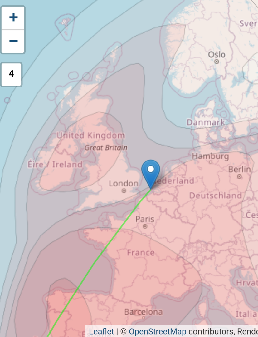
There are ongoing discussion on the connectivity architecture and the most efficient way to implement the communication link between the vessel to the cloud and the shore control center. The coverage map for satellite communication was extracted during the first phases of the project.
The provided map in Figure 3 is a typical coverage map of a satellite telecommunication system. The different areas in different intensity of colour represent areas within the same satellite EIRP (Equivalent Isotropically Radiated Power) range.
The EIRP represents the intensity of the radio signal available from the satellite in the specified region. Higher colour intensity indicates higher radio signal power and hence better coverage.
Subcontractor(s)


