
Objectives of the service
SEOS is an initiative led by Ecometrica to advance applications of Earth Observation (EO) in Scotland to increase the consistency, continuity, extent and usefulness of geospatial content through the provision of services that address environment and land management challenges faced by a number of Scottish public and private organisations.
The project developed services for commercial forestry companies that reduce the cost of labour intensive in-person surveys by leveraging satellite data, airborne LiDAR data and machine learning to provide forest and vegetation condition reports and dashboards.
Services are delivered via the Ecometrica Platform - a cloud Software as a Service (SaaS) solution to visualise data, generate asset level reports and portfolio level business intelligence dashboards. Included in the service development are pioneering data products on forest metrics developed by Artificial Intelligence and Machine Learning satellite data processing partner, Global Surface Intelligence (GSI).
Some of the key tasks that were completed during the project include:
-
Review of user needs and requirements of Scotland’s land management stakeholders
-
Flying LiDAR and data processing in clients’ areas of interest to improve understanding of what works, de-risk new methods and guide future development of geospatial content from EO.
-
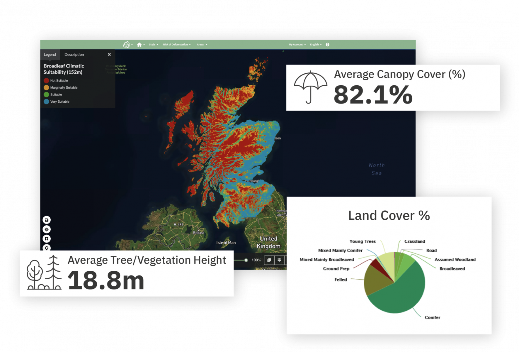
Development of large scale maps (50,000 hectares) for forestry valuation and investment - including height, species and merchantable volume to increase consistency, continuity, extent and usefulness of geospatial content derived from EO.
-
Development of easy access service models for accessing EO data including an off the shelf, digital sales process to reduce the costs and improve timeliness of accessing EO derived information.
Aside from the service development, SEOS aims to prove an innovative business model that can be scaled to countries beyond Scotland and facilitate partnerships across the SEOS network between data producing organisations and users.
Users and their needs
The ESA Demonstration Phase of SEOS is focused in Scotland, with organisations who are interested in accessing EO derived information on vegetation conditions. The key sectors engaged are forestry, conservation and devolved agencies.
For forestry, a key challenge is efficient access to reliable and affordable information on the value of forests in Scotland considering specific metrics such as tree height, species and merchantable volume. Currently, there is a lack of targeting within forest mensuration from purchasing companies, who cite inefficient operational costs as a use case to address. There is also a lack of data generally about the state of forests for sale in Scotland.
For conservation organisations, an important focus was on access to improved and affordable information about woodland fragments in Scotland's remote locations. Currently, in many areas, this information does not exist and is vital for organisations such as the Woodland Trust to create feasible and effective restoration plans. Collecting the information by field survey would be impractical and costly, as the areas are expansive.
Devolved agencies and the public sector need to be able to access cutting edge EO derived information all in one place in an easily shareable and storable format. Currently, there is a lack of organisation/awareness of data across the UK environmental public sector.
Across all user groups, there is a need to reduce costs and increase usability/ease of use of EO data, which will be addressed by developing easy-access models and a low cost, innovative business model.
If the demonstration phase is successful, there is potential to scale the model to Canada, North America and Scandinavia.
Service/ system concept
SEOS is a one-stop-service for organisations and individuals seeking fit-for-purpose, easy to access and affordable insights from EO derived sources. There are libraries of data from a myriad of expert organisations on vegetation conditions in Scotland - covering habitats, peatlands, forestry measurements and land use change. Datasets are then collated into pre-set applications where customers can:
-
Use SEOS website to find out more information about products and services
-
Upload an area of interest - point or polygon
-
Request a report utilising datasets
-
Pay online
-
Receive the insight within a day
If customers need higher levels of access, applications will be available to purchase where they can overlay numerous areas of interest, overlay their own geospatial information, design and set up reports themselves or even run new services to external markets using the SEOS application.
The system service architecture required to deliver the service is shown in the diagram below:
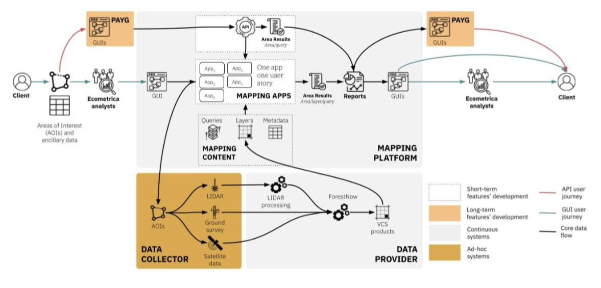
From this architecture are able to provide distinct applications for user sectors including:
-
Forestry: Valuation and Investment Metrics
-
Ecology: Habitats, Biodiversity and Soils
-
Future Woodlands: Suitability, Peatlands and Carbon Benefits
-
Optional high resolution survey where deemed required by customer
Space Added Value
SEOS Value Addition from Space Assets
The key space assets used within SEOS are satellites collecting information which underpin SEOS datasets. There will be some publicly available satellite based datasets, such as Sentinels 1 and 2 (ESA Landcover Maps, and privately produced Global Surface Intelligence Maps). In addition, we will utilise drone and aircraft flown LiDAR to add value to satellite based mapping through GSI’s proprietary processing methods.
The value addition from existing space assets lies in the aggregation and combination of datasets that are typically used by earth observation experts and people with geographical information systems knowledge only. By combining the datasets to answer business questions from external industry, SEOS can help mainstream satellite derived insights into operational decision making in new sectors.
In addition, satellite based mapping is often undertaken on a project by project basis, and not funded for the long term. By setting up SEOS, we intend to test a model where satellite derived information attracts revenue from new sectors and can be reinvested in the upkeep, maintenance and development of ever-evolving and improving satellite based insights.
Current Status
The pilot phase of SEOS is now complete, and products are available to purchase at www.seos.org.uk
Customers can enter points or drop a pin in a map to receive information covering the following themes:
-
Natural Capital: rapidly quantify baseline measurement for habitats and biodiversity in your areas of interest, and monitor impact over time
-
Physical Climate Risks: Assess your area of interest’s exposure of sea level rise in 2030 against different IPCC scenarios
-
Future Woodlands: Identify which areas are most suitable for the creation of new woodland, and what type of forest to plant within your areas of interest
-
Forestry investment (in 3 regions - Speyside, Dumfries and Galloway, Loch Arkaig and the Great Glen) : Quick analysis of key forest metrics such as species, density, height and constraints to extraction based on slope
-
Carbon Assessment - by specific purchase only : Harness the power of very high resolution LiDAR data to quantity carbon in forests without lengthy field campaigns.
SEOS applications can also be licensed at set fees if organisations wish to have higher levels of access.
If you are interested to learn more, please get in touch with the Ecometrica team at space@ecometrica.com