Objectives of the service
It is evident that a data-driven approach is crucial for understanding the role of forests in mitigating climate change, managing forests sustainably, protecting biodiversity, and achieving global climate goals. However, most cities, regions and landowners do not yet have access to detailed information on the carbon accounting status of their biomass, the vegetation health condition, and-in particular-carbon sequestration optimization potentials associated with their land. Moreover, the emerging forest credits market demands authenticity, transparency and technological innovation to become a successful means for offsetting carbon.
To this end, SequOIA-CAM’s vision is to function as a monitoring, reporting and verification (MRV) tool built into a web-interface that organizations and individuals can use to manage their forest better, monitor existing carbon projects and create new forest carbon projects, conserving and restoring several areas of forest lands and green spaces worldwide.
Users and their needs
The key users targeted by our services are:
-
Local forest owners, forest organizations, national and private forest authorities interested in forest monitoring and carbon certification
-
Forest management companies, forest consultancies, carbon offset certifiers and sellers
-
Forest tech companies, climate finance, logging companies, forest investors and forest certification entities
These users have been prioritized as they deal with forests regularly and require real-time information for
effective management and decision-making.
The core user needs are:
-
An easy to access user interface and that provides up-to-date maps of forests, timely warnings of forest changes, forest risk and vitality maps, damage reports, and tools for communicating between forest owners and other third parties
-
Automatic identification of forest risk areas (deforestation and degradation)
-
Automatic mapping of above ground biomass, carbon stored in forests and city trees
-
Simulation of carbon sequestration and forecasting
For example, SequOIA-CAM’s pilot customer, the City of Garbsen expressed their lack of resolution to monitor trees and the need for an appropriate software infrastructure or capacity to regularly monitor health of individual trees, which are in significant risk due to changes in climate over the last two years. They need tools to that can be used by city administration authorities with no in-depth knowledge of software/data analysis to monitor and prevent trees from withering off and to identify areas with high carbon storage potential. Information on when, where and how much to irrigate is crucial to managing green spaces in cities.
SequOIA-CAM provides cost savings for carrying out such tasks, thanks to updated city vegetation maps at together with our web based digital tools. Furthermore, SequOIA-CAM empowers local forest owners to implement optimized forest management strategies, such as reforesting with suitable tree species, identifying areas available for reforestation, and mapping high-risk forest areas. If a local forest owner or an organizations wants to apply for carbon certification, they can use SequOIA-CAM to get an estimate of current storage potential and future carbon potential based on several factors (temperature, precipitation, tree species, season etc.) using our forest carbon sequestration simulation and forecasting services. The combination of all these features in a single platform makes it an ideal solution for our targeted user group.
We have already established contacts with competence centre forest and wood (K.W.H) to acquire test dataset for training our core machine learning models and to get forest organizations involved in the project. The project seeks to determine the feasibility of satisfying the above user needs, updated on weekly basis, and made available on a web portal for a subscription fee.
Service/ system concept
SequOIA-CAM is a web-based tool that uses satellite data to offer its services. Access to the tool is available through a subscription. Once a user logs in, they can select from the services outlined in the system architecture diagram. After making their choice, the user can draw a polygon on the map displayed on the webpage. This creates a shapefile for the area of interest (AOI). The relevant satellite data is then accessed via sentinel-hub for the selected service, and the data processing is triggered. The results are provided as interactive maps, static maps, reports, and more. These outputs are generated by the AI model and stored in the cloud for the user to view and download.
Space Added Value
The innovative nature of the SequOIA-CAM solution stems from our combined Big & Smart Data analysis using novel Data Science and AI methods applied to a variety of space data resources, such as ESA's Sentinel-1 & 2, Planet Dove, GEDI (Global Ecosystem Dynamics Investigation) and Landsat-8 data to estimate e.g., tree cover, forest height, above ground biomass, quantify carbon stocks, and forest resources. Other satellite resources like GEDI provide e.g., precise geographical locations, making model accuracy improvements possible by measuring carbon stored in canopies.
We feed our OmegaLambdaTec deep learning models with various vegetation indices and textural information derived from Sentinel-1, Sentinel-2 and Planet Dove and train them with relevant ground truth data and reference datasets to provide accurate and timely information on Forest health and carbon.
Current Status
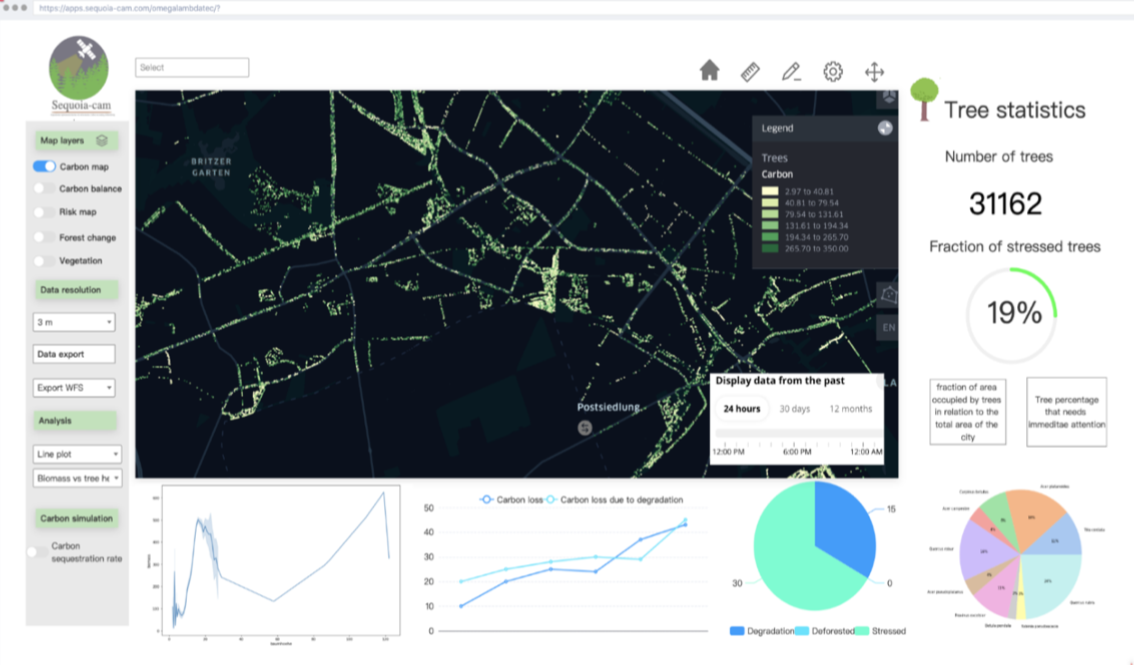
The project was initiated in July 2022, and we successfully achieved the Final Review (FR) milestone by February 2022. Through multiple interactive sessions with our pilot customer, the City of Garbsen, we collected potential user needs and scenarios, and engaged with a diverse audience of 30 users/ associated with the Competence Center forests and wood (https://www.kwh40.de/). Based on all the user engagement activities carried out, we developed mock-ups or early concept ideas (see fig 1&2) for SequOIA-CAM, which were validated by our user group from the City of Garbsen.
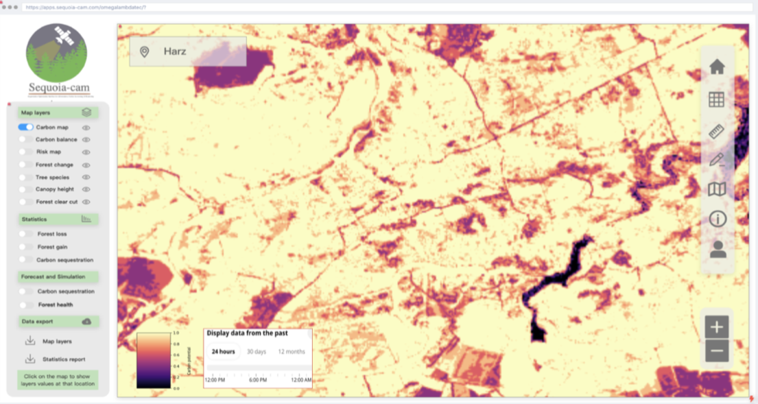
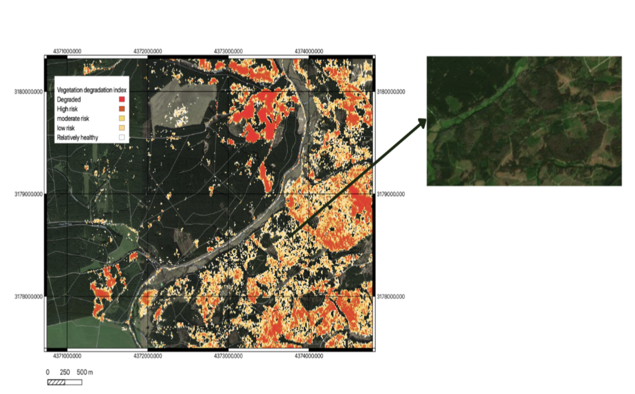
We have created workflows and pipelines for other services that will be implemented during the demonstration phase of the project. In addition, we showcased our Deep learning and statistical model capabilities to map tree cover and potential forest risk areas (refer to Fig. 3). We are currently in discussions with potential associate partners to gain access to ground truth data, which will aid in further developing our models. Furthermore, we are in talks with potential associate partners with expertise in forestry to support the development of SequOIA-CAM. We are currently applying for the demonstration phase of the project and are eagerly anticipating the opportunity to work on the remaining core technical components of the service and develop a minimum viable product (MVP).
Prime Contractor(s)