Objectives of the service
The study has been performed through 4 different steps leading to a preliminary definition of a system able to provide services helping European, national, or regional institutional agencies in the border surveillance and emergency activities.
As a first step, interviews have been done with stakeholders in order to define their main needs and requests. These discussions have allowed to define scenarios useful to the stakeholders as well as a set of user requirements to be fulfilled by the HAPS system. The following scenarios have been taken into account for designing the system: maritime search and rescue, fight against illegal activities, industrial site monitoring, crisis management and disaster relief.
As a second step, technical requirements of the system answering to the need have been derived from the user requirements. Then an architecture of the complete HAPS system including airship (support platform + mission elements) and ground facilities has been defined. And finally the concept of use has been detailed.
As a third step, the viability of the system has been evaluated. The competitive environment has been analysed as well as the strengths and weaknesses of the defined system and the non-economic aspects have been assessed. Then the value chain and a business model have been built to conclude on the viability.
The study has been finalized by preparing a roadmap to achieve a first demonstration of the services/scenarios defined in the first step.
Users and their needs
The users potentially interested by the use of a HAPS as a complementary mean to the satellite data are various: defence ministries, public authorities or industrial companies.
The applications identified in the study as the most relevant for the users are the site monitoring, the cartography, the target detection, the linear tracking and the operational support.
The following key points and requirements that are mandatory for users have been identified:
- the real HAPS gain is continuous monitoring and persistence above an area. To take a maximum advantage of this specificity, system must be equipped with instruments that allow day and night as well as bad weather observation. Thus, Thermal Infrared receiver is mandatory which would be a real lever on the market. By priority then, optical (Ultra High Resolution) and Synthetic Aperture Radar,
- for HAPS operational control, the center must allow the user to modify the flight plan or easily redeploy the HAPS; the same center must be able to command existing systems (drones, satellites). The center must be located in an area that allows a very low latency for information transmission (QRT quasi real time),
- To be more efficient from an operational concept perspective, HAPS must be equipped with an automatic data processing tool for basic objects detection. Automatic fusion and correlation between different sources of data must be performed airborne.
European users are targeted.
Service/ system concept
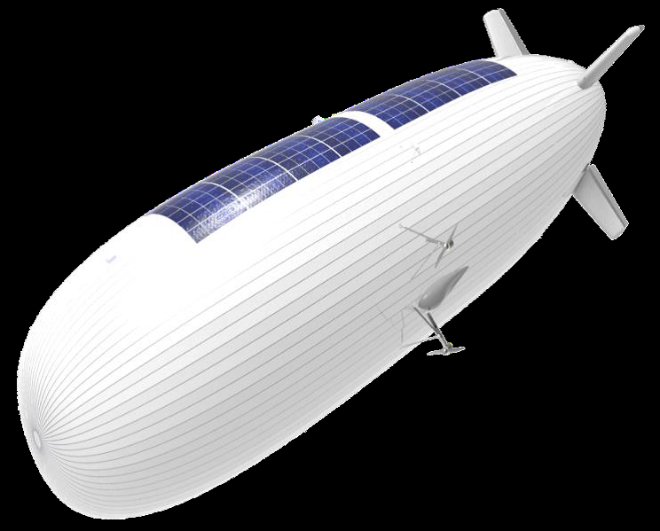
The system designed is composed of an airship and a ground part. On the airship side a generic platform allows the accommodation of different instruments leading to various missions operation. The ground part of the system consists in the control station of the platform, the stratoport and the mission station.
The generic platform will manage the power generation, the propulsion, the communication links with the ground control station, take care of the good health of the airship. It includes a balloon with a volume of 85 000 m3 at mid pressure, a length of 140 meters, a diameter of 32 meters and gondolas to accommodate equipment. The platform is stationary with a velocity from 20m/s raising to 25m/s along model development. It uses 4 electrical motors optimized for stratosphere and tails & rudders for manoeuvrability.
For the objective of surveillance mission providing wide area, wide range surveillance capabilities, the implementation of several complementary sensors has been decided: a multirole X-band radar, an optical head with visible and infrared capabilities, a multispectral camera.
The ground control station includes a control center, an RF link with the platform and an emergency recovery system. The control center takes care of the attitude and trajectory of the airship considering the mission request, the StratobusTM platform location, the Air Traffic Management (ATM) / Higher Airspace Traffic Management (HATM) instructions/authorizations and the meteorological conditions.
The stratoport is constituted of the infrastructures allowing the airship to be integrated, operated and maintained.
The mission station includes the mission management center and an RF link with the instruments on-board. The mission management center defines the mission plan and ensure the mission data acquisition & processing.
Depending on the service concept (buy, lease, full service), the ground control and mission stations will be owned/operated either by the end user or the service provider.
Space Added Value
The HAPS dirigible fill the gap between satellites and UAV/Aircraft thanks to:
- High endurance (>weeks) for a mission (solar powered),
- Both satellite-like and UAV-like services,
- Multimission,
- Continuous coverage,
- large payload & ability to remain geostationary
Current Status
The feasibility study is finalized:
- User needs discussed with different users, operational scenarios and user requirements consequently defined,
- Technical requirements derived from user requirements, architecture and concept of use of the system consequently defined,
- Viability evaluation done through competitive environment analysis, strengths and weaknesses of the system and non-economic aspects assessment, and business model elaboration,
- Roadmap for a demonstration of the services provided.