Objectives of the service
During the last years, many remote sensing techniques have been developed to study hydro-geological events, almost all of them focused on studying the causes and effects in the aftermath of the event.
The objective of SMART program is to improve the forecast capability of hydro-geological events (flooding and landslides) through the use and integration of satellite data (TLC, EO, NAV), and to enhance the quality of information by an integrated provisioning of heterogeneous information sources. SMART program also addresses the post event management through the development of a solution for real-time information exchange among first responses operator with in emergency situation aimed at increasing situation awareness capabilities.
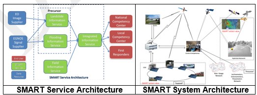
SMART is the composition of different, yet complementary, Information Services each aiming at the provision of data related to specific elements of the natural resource protection process. An Integrated Information Service drives the Information Specific Services, namely the Landslide Information Service, the Flooding Information Service and the Field Information Services, to the appropriate end user community: each user/customer will receive only the information set which is relevant for his own area of action/interest.
Users and their needs
In Italy, the hydro-geological event management is under the responsibility of the national Civil Protection. The Department of Civil Protection is a structure of the Presidency of the Council of Ministers. It provides the country with an organization capable of mobilizing and coordinating all national resources useful to ensure assistance to the population in case of a major emergency. Other actors involved in hydro-geological event management, and so potential end-users, are:
- Local and regional institutions, assigned to land management that organize local resources
- Firefighters to rescue people and resources.
- Ministry of the Environment as part of its activities for the protection and defence of natural resources
- Ministry of Defence, supporting field operations in situations of pre/ post critical events
Data acquired via the SMART services can increase and consolidate statistics which are a primary information sources for customers such as:
- Insurance companies that would use additional information of "hydro-geological risk" to better organize their insurance policies.
- Construction companies and infrastructure operators, interested to know 'accurate data’ of hydrogeological risk for planning safety monitoring of existing facilities or designing new structures.
Some relevant user needs
- Monitoring landslides over time
- Landslide backward analysis (i.e. comparative analysis based on historical data of the area of interest)
- Monitoring Landslides near urban areas using natural (existing) permanent scatterers
- Early warning alert for rivers crossing towns/cities
- Broadcasting Alert for disadvantaged categories of citizens
- Availability of timely data, to take the right decision at the right time
- Situational awareness at Control Room via team of non-expert field operators
- Coordination services, for squad of first responders to improve the safety and the effectiveness of their operations
- Coast monitoring to detect coastline change over time
Snow volume monitoring
The users actively involved in the study were the Italian Civil protection at central level (Department), at regional level (Apulia) and at territorial level (Genova)
Service/ system concept
The SMART system delivers the following services:
- Precursor Information Services:
- early warning information sources: Landslide Information Services, Flooding Information Services
- Field Information Services,
- real-time information about the status of operational areas
- Integrated Information Services:
- package of information services tailored for specific user needs
The SMART System leverages on a data-centric architecture based on the Data Distribution Services (DDS) a standard real-time middleware specified by the Object Management Group. Specifically, SMART is built upon the BEE-DDS product manufactured by Finmeccanica. The SMART System is composed by four main components/subsystems :
- Landslide Information Service Subsystem based on satellite SAR data for the landslide monitoring both in backward-analysis and continuous monitoring using natural permanent scatterers and artificial corner reflectors
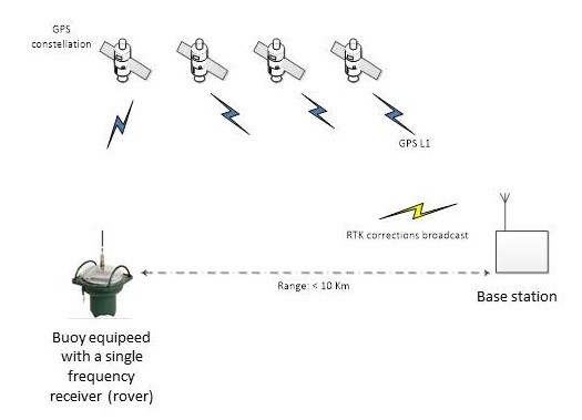
- Flooding Information Service Subsystem based on an innovative sensor placed in a buoy, which uses an RTK-based low cost GNSS receiver.
- Integrated Information Service Subsystem and Field Information Service Subsystem that provide a data-centric information infrastructure to support control rooms and Squad Coordination, composed by:
- BEE Sense, a DDS-enabled cluster of smart sensors and effectors
- BEE AWARE, a dual-use smart personnel equipment, developed for military missions and adapted to support first responder squads to improve his/her situational awareness and the squad cooperation
- a SATCOM node that extends the data-centric architecture to remote sites
Space Added Value
SMART Services adopt the following space assets:
- Satellite SAR images
- EGNOS
- TLC Satellites
The Flooding Information Service is based on the HydroSAT sensor network. The HydroSAT sensor measures the vertical displacement caused by the rising river’s level and sends an alert to a remote station if the river’s level is above a set threshold. Different thresholds can be set, related to different levels of alert. Moreover, it is possible to collect the collected measurements remotely. The communication link can be a GPRS link or a satellite link, depending from the cost and area to be covered. The HydroSAT sensor is based on RTK-based low cost GNSS receivers and with respect to currently used hydrometers it has the attractive characteristics of: i) having a cost which is much lower (one order of magnitude); ii) being more flexible in the positioning of the hydrometers, which can be located along the rivers path and not only close to urban areas and under bridges. This solution greatly helps in extending the current monitoring system.
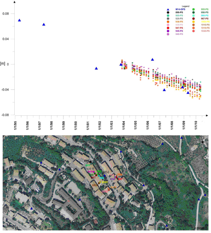
The Landslide Information Service is based on DInSAR analysis using SAR data acquired from the in-orbit, past and future constellations.
Differential SAR interferometry allow us to monitor phenomena such as landslides using multi-mode Synthetic Aperture radar (SAR) operating at C/X-band through the use of natural permanent scatters or artificial corner reflectors. The main advantage over other conventional techniques is the possibility of very precise displacement measurements over large, urbanized and countryside area at reasonable cost without the necessity to perform the traditional and extensive field measurement campaigns. The system is designed in a way that end-user can operate the DInSAR analysis on-demand selecting the Area of Interest (AOI) and obtaining directly its Line-Of-Sight (LOS) displacements over time.
The Field Information Service exploits satellite connectivity to guarantee the Control Room increased situation awareness and constant operational picture updates, especially during crisis situations.
Current Status
The study started in June 2015 and has been completed in November 2016. The consortium was able to engage users from different offices of the Italian Civil Protection collecting requirements from local, regional and national staff of Italian Civil Protection that have driven the PoC development and validation phases.
Technical feasibility of the Smart system has been demonstrated for all its components:
- Landslide Information Services: based on Time Series Interferometry and delivered as Web-Service it improves the capability of the end-user to monitor continuously both the urban and rural area to identify active landslide phenomena (in the pre-event phase) and to perform damage assessment in the aftermath of an event
- Flooding Information Services: based on the use of a novel sensor, the HydroSAT sensor, consisting of a buoy equipped with a low cost GNSS receiver able to measure vertical displacement within 20cm, can be used to economically extend the number of rivers and areas monitored improving emergency management and prevention
- Field Information service: based on use of DDS standard, it improves the Situation Awareness (SA) of the single operator and provides a Common Operational Picture (COP) to both the first responders operating in the field and the tactical and strategic control centres for a cooperative management of the disaster. It can improve the quality of the operators’ decisions by providing them with QoI-based services.
- Integrated Information Service: it is based on consolidated Service-oriented architecture (SOA) and allows composition of basic SMART services into a unified control centre customized according to end user needs.
The viability analysis performed confirms that the SMART services are feasible in terms of regulatory and operational aspects, and can be offered as a profitable line of business to users in disaster response organizations in Italy and across Europe both for routine monitoring services and emergency management services.
Based on the PoC results, a Demonstration Project, managed by the same consortium, is foreseen for validation of the system and service uptake by end-users targeting commercial rollout of the SMART services in 2019. To this aim, two demonstration campaigns with two CP centres across Italy are planned; each campaign addressing the prevention and post event response usage scenarios. The final objective of the Demonstration Project is to present the system and services in a way that inspires trust and at the same time equips users with a strong sense of the innovative appeal of the SMART services.