Objectives of the service
The main objectives of the solution relate to the technological improvements of fishing vessels concerning the maintenance and work operations, the reduction of fuel consumption, the increase in productivity of fishing activities, guaranteeing safety of vessel crew, as well as monitoring and reducing vessels environmental impact.
Users and their needs
The main users are shipowners, ship captains, fishermen on-board, technical collaborators (e.g., mechanicians, electricians, etc.) who are in charge of the smooth functioning and maintenance of the vessels, port authorities. The management and monitoring of the fishing fleet, carried out by shipowners and port authorities will be performed through SMARTFISHING, that will provide near real-time diagnostic information of each vessel, along with an alerting system to prevent safety risks and support urgent decisions. Moreover, the solution would enable efficient and smooth vessel-to-ground communication (e.g., automatic entry alert of the vessel within the port area). Therefore, fishing companies and port authorities would be both customers and users of the proposed solution.
The needs mainly consist in improving the productivity of fishing activities by carrying out cost and time savings practices, avoiding lack of efficiency and containing maintenance costs. More specifically, shipowners and fishing companies express the need to monitor fishing vessels parameters in order to mitigate the economic and safety risks that could arise during the fishing activities. They also want to improve navigation routes in order to decrease fuel costs and optimise fishing activities in compliance with fishing and fuel consumption standards set by authorities. Port authorities mainly express the need to monitor fishing vessels parameters to improve maritime vessel traffic management, control overfishing activities and off-shore support in case of emergency. Finally, shipyards and vessel design companies are stakeholders interested in integrating relevant technological improvements to the new generation of fishing vessels.
Service/ system concept
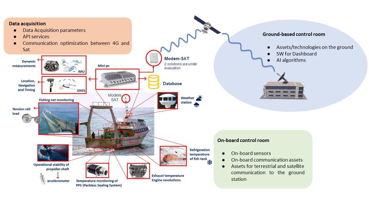
SMARTFISHING is based on the integration of sensor-based Internet of Things (IoT) technologies, data acquisition, data analysis through Artificial Intelligence (AI) algorithms, Satellite Earth Observations (SatEO), advanced Position, Navigation, Timing (PNT) solutions, generation of data-driven models and data transmission set up by terrestrial and Satellite Communication (SatCOM) systems.
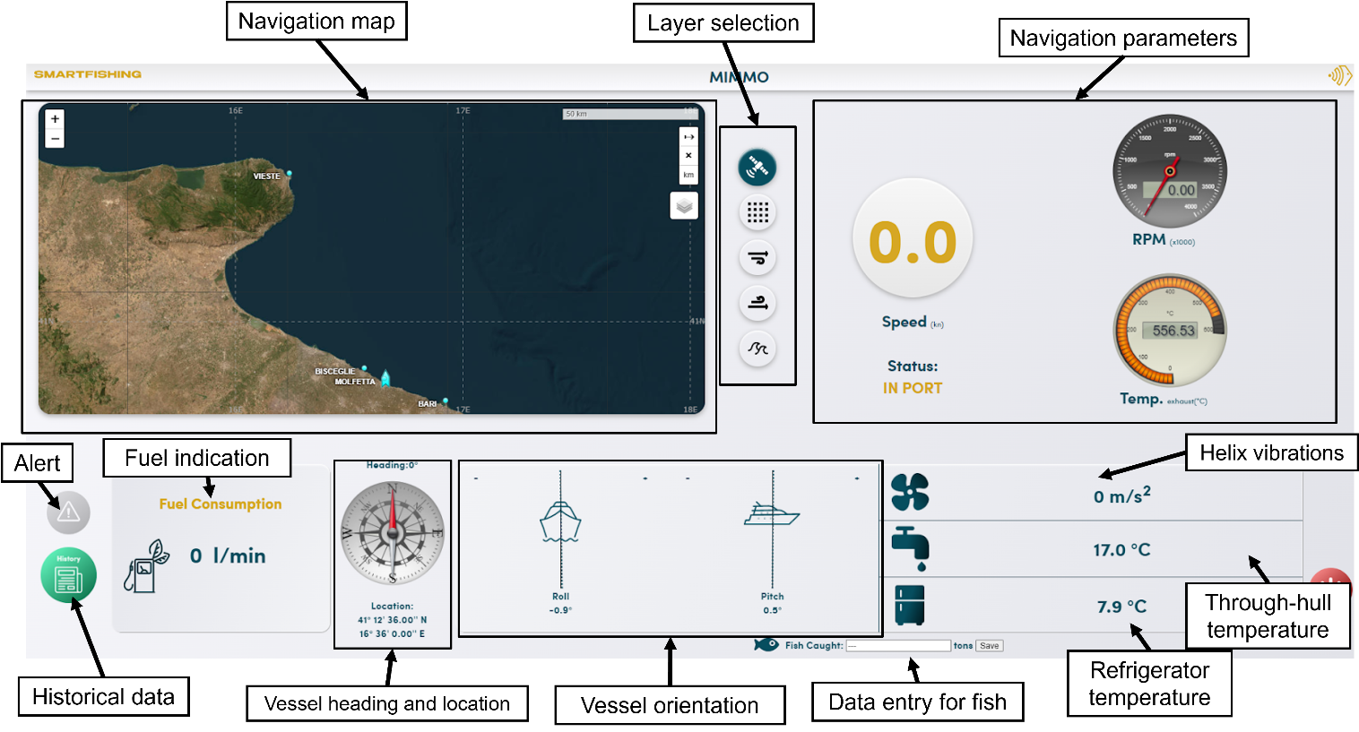
The final service will be offered as a Decision Support System (DSS) to fishermen/ship captains, , shipowners and port authorities to support fishing activities, check the fleet status (e.g., failure detection and management) and give a real-time benchmark of the fuel consumption to improve the efficiency of the fleet. The main module of SMARTFISHING is the analysis of a wide variety of data in conjunction with inputs given by sensors installed on-board and satellite assets, namely PNT and SatEO data. The analysed parameters are mainly related to the vessels’ status, fishing activities, weather and sea conditions, to optimise the operations.
The innovative element of the proposed solution is based on the combination of a wide range of technical solutions, integrating space assets and Artificial Intelligence (AI) techniques, to provide a comprehensive DSS for shipowners and fishermen to prevent failures and inefficiencies, thus optimising fishing operations. The AI algorithms will be implemented in the proposed solution to generate data-driven models produced from data acquired by sensors, vessel parameters, SatEO and PNT. When dealing with fuel consumption, it is widely believed as one of the major elements in the operating cost structure of fishing companies and of the maritime industry in general.
Space Added Value
The proposed system leverages on Satellite technologies for Data Communication, Advanced PNT and Earth Observation. For the Positioning, Navigation and Timing, the vessel uses a GNSS receiver to retrieve data. The added value offered by this solution, compared to the current mandatory VMS on-board, consists in the interpolation of PNT data with other relevant information (both endogenous and exogenous) in order to increase efficiency and take informed decisions on fishing, sailing and maintenance activities.
The other space asset included in the proposed solution is SatEO, which can provide the status and prediction of the sea conditions to be integrated in the data model for analysis and prediction of navigation routes towards fishing zones. The services provided by SatEO are crucial for the creation of a comprehensive dataset to analyse the behaviour of each vessel along the routes towards the fishing areas.
In detail, during the pilot phase of the project, the instantaneous measures related to the current vessel activity (position, velocity, fuel consumption, cargo mass) acquired by on-board sensor systems will be complemented by data retrieved by SatEO services, in order to gain insights about the dynamics of the vessel in the external environment. Moreover, SatEO services provide forecast data that will be useful to predict the behaviour of the vessel for future fishing activities. The ad-hoc AI models of each vessel will therefore be used to compute the expected behaviour of each vessel of the fleet assuming the sea conditions, in order to find the best routes and optimise the scheduling of the fishing activities in the different fishing zones, thus making the work more efficient and mitigating risks
Current Status
The On-Site Acceptance Test meeting was successfully concluded on 10th May 2024.
The pilot demonstration has officially started. 3 groups of users are involved to validate 3 main objectives of the solution in an operational environment:
-
confirm the product effectiveness in decreasing the fuel consumption and costs related to fishing activities, through the analysis given by AI models.
-
guarantee an efficient communication system between the on-board and remote monitoring systems, able to handle data with different priorities and requirements.
-
ensure a future commercial success to the solution
The Final Review meeting is going to take place on 15th November 2024.
Prime Contractor(s)