
Objectives of the service

The proposed services are conceived to support the prevention operations for weather-related road risks, through the provision of detailed and reliable forecasts, specifically designed to be naturally integrated in the users' operating procedures. Accordingly, the services are addressed at companies and organizations operating in the sector of roads maintenance, with the aim to make more efficient and economical the typical winter road management operations, such as snow removal or the spreading of anti-icing road salt.
As timely and correct road management operations are essential to ensure the safety of drivers in severe weather conditions, the availability of detailed and up-to-date weather risk forecasts is certainly a key requirement. For this reason, the SmartMetRoadMap production platform is based on numerical meteorological models integrated with a suitable recurrent neural network (RNN), so to be able to exploit the information content of different types of data and ensure up-to-date reliable short-term forecasts.
More specifically, the SmartMetRoadMap production platform has been designed to acquire not only information from in-situ weather stations, but also from satellite-based radiometers, weather RADARs and all relevant data which in the near future will be available directly from smart cars.
Users and their needs
The users of the services offered are all those who have a duty to keep the roads as safe as possible:
-
regional or inter-regional public road management authorities;
-
service companies in charge of winter operations by the competent authorities;
-
road police;
-
local police;
-
local, regional and national civil protection authorities.
Since road safety certainly plays an important role in the security of citizens in general, the subjects involved in managing this aspect are different, often with overlapping tasks. The main user needs also derive from this evidence:
-
effective planning of the operations for the prevention of meteorological risks on the roads:
-
effective management of critical situations (e.g. emergency interventions during severe weather conditions);
-
effective sharing of information, even between subjects with different organizational models.
-
ensure road safety in all weather conditions at affordable costs.
Service/ system concept
Thanks to the features described below, SmartMetRoadMap services allow users to enjoy all the benefits of detailed and reliable forecasts in the managing of weather-related risks on the road networks.
Operation managers & road operations staff
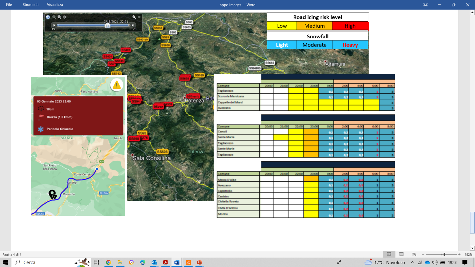
GIS maps and synthetic tables with the indication of the meteorological risks for the current day and the following six days. Both maps and tables can be viewed through dedicated mobile friendly web pages, have hourly resolution and are organized to account for several road sections and subsections, personalized on the basis of the customers' internal organizational model.
A supply of data with standard and secure procedures is also envisaged, which allows the users to
-
customize the available tools in a simple and intuitive way;
-
view the maps and tables on the customer's intranet;
-
view the maps on their own device via the most popular web-GIS clients (e.g. Google Earth), simply by means of a pre-built one-off plug & play installation;
-
have an archive of the forecasts provided, which can be consulted in the same way as for the operational supply;
-
measure the performance of the system by means of customizable analytics.
Road operations staff
Mobile-friendly dedicated web pages showing synthetic tables of the meteorological risks relating to the road sections under responsibility of the specific operator. The showed tables represent the various risk as codes related to the appropriate operating instructions (spreading of the correct type and quantity of road salt, checking the state of the asphalt and the conditions of vegetation and roadside signs, positioning of suitable signs and provision of safeguards).
"Early warning" app designed to support operations in emergency conditions, based on a GIS map showing
-
the user current position;
-
the operator's routes (i.e. the road section to be monitored);
-
the type and degree of meteorological risks relating to the current position and the immediately following road sections.
If requested by the customer, the "early warning" app can be made available for download by general public or users from other organisations.
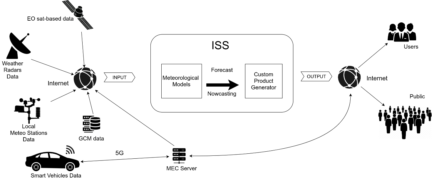
The service production system has the classic scheme of integrated sounding systems (ISS), which can be schematized in three macro blocks: input, processing and output.
The input block contains modules for the pre-processing of input data from the available weather sensors and general circulation models.
The processing block contains the local meteorological models and RNN-based modules, which process the medium, short and very short term forecasts.
The output block contains the post-processing modules able to generate and deliver the customized services to users.
Space Added Value
A reliable forecast of weather-related risks on roads is essential to decide the priority of prevention operations, especially in case of severe weather conditions. Nowadays, suitable forecasts for such a purpose are possible thanks to nowcasting techniques, as they consent highly reliable short-term weather forecasts with excellent spatial and temporal detail.
There are several techniques for nowcasting, but they all involve the availability of real-time measurements that allow monitoring of the weather conditions in a given area. Satellite data can certainly make a great contribution to nowcasting, especially in the light of the improvements guaranteed by the new MTG satellites. On the other hand, the extraction of meteorological information from satellite-based remote-sensing measurements requires several processing and this can give rise to incorrect estimates, especially if adequate techniques are not used.
The SmartMetRoadMap platform has been specifically designed to extract reliable meteorological information from satellite and remote sensing in general, in order to allow it to provide services based on high quality nowcasting forecasts, even in the absence of a capillary network of surface meteorological sensors. This feature guarantees the SmartMetRoadMap service package to be a highly competitive solution in terms of costs and performance, compared to the currently most widespread solutions on the market.
Current Status
There are currently seven customers and several dozen users in Italy who use the services provided by the current platform. Three of these customers have been contacted for feedback on the planned upgrade.
A specific meeting between HIMET and ANAS Abruzzo has been set for June 2023, to verify with the management and operational staff of ANAS Abruzzo the SmartMetRoadMap value proposition.
The core of the new platform has been set-up, including a first release of the RNN-based module able to ingest data from selected in-situ weather stations. The RNN-based module has been trained by using three years of selected stations’ data and NWP model output.
The case studies to for the evaluation of the best products from satellites and weather RADARs to be used as input to the RNN have been identified and the activities for their analysis are started.
The functions and specifications of the support app for operations in critical weather conditions have been completely defined, and the first tests have been carried out for the acquisition of the specific products supplied by the production platform.
Prime Contractor(s)