
Objectives of the service
Commodities supply chains are high emissions emitters, and also highly exposed to the effects of climate change. Whether it is wildfires, flooding, drought or cyclones, supply chain disruption causes billions of dollars in damages annually. This effects owners and operators within these supply chains as well as investors and financial institutions. This service aims to provide long-term and near-real time monitoring of the risks and emissions that occur across these global networks.
Users and their needs
- Commodities market intelligence firms who are seeking to understand global patterns of climate activity, and provide insights on how this activity will effect commodities prices.
- ESG Consultants and advisory firms looking to disclose the climate-related risks within the asset portfolios of their Private Equity customers.
Global context of data and customer base for the SMOCGEO product, although customers to-date have been in Europe and North America.
Service/ system concept
Users will be able to assess the forward-looking climate risks that threaten assets they own. For example, wildfire risk, flooding risk, cyclone risk.
Additionally, users will be able to monitor the emissions from large commodities production facilities, such as mines and smelters.
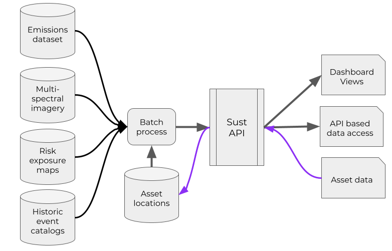
The system ingests multiple geospatial and satellite datasets, and applies asset-level assessment of risks. The customer can access these insights via a web analytics dashboard, direct via API, or in a .CSV file.
Space Added Value
This project uses the Sentinel Satellite 5p (Tropomi) which can conduct SO2 and NO2 emissions monitoring. We provide indicators in near-real time (weekly/monthly cadence), compared to current data gathering time of 6-12 months. Our scalable, cloud-based technical infrastructure enables analysts to interact with millions of data points across the globe, versus previous manual data gathering processes via physical visits to sites. Satellite and machine-learning based technology allows us to unlock new indicators on global activity/sustainability which were previously unattainable. We also use satellite derived technology to improve the cadence and resolution of forward looking climate risk datasets, e.g. using wildfire detection sensors from NASA Modis, we can 16x resolution against existing models.
Current Status
- Held workshops with two customers via Zoom, enabling us to understand the use-cases and customer-facing opportunities.
- Scoped SSAs and technical features of product.
- About to start Software Development and feature construction for web analytics dashboard.
- Begin developing the API-based product integrations.
FEB 2022 UPDATE:
The SMOCGEO project is now complete, and the product is being used by paying customers and their feedback is leading into further development. Sust Global created an MVP of the emissions monitoring capability and delivered insights to pilot customers via a dashboard and API function. We successfully released the physical risk, emissions and built up area analytics to customers, and using customer feedback, we improved our speed and ease of use to drive customer retention.
If you would like to know more, please get in touch with us at sustglobal.com