Objectives of the service
Large areas of the world – almost the entire land surface of the Northern Hemisphere is affected by snow cover; including strong dynamics e.g. snowfall & melting in short periods.
The snow is the basis of hydropower production, and critical for flood events, and other aspects of daily residents’ life and economy.
Since the most relevant parameter, the water stored in the snow cover, known as the Snow Water Equivalent (SWE), is only measurable by costly automatic stations or manual field campaigns, the information for remote areas – not densely populated or equipped with traffic infrastructure - is mostly missing.
SnowSense designed, developed and demonstrated a pre-operational service for the area of the island of Newfoundland / Canada. By using a novel, GNSS based in-situ snow monitoring system, in combination of existing technologies (EO and water balance modelling), the gaps of knowledge of the SWE in remote or mountainous areas could be filled.
SnowSense established to provide novel Snow Water Equivalent and Liquid Water Content measurements, using own developed low cost GNSS based stations, with proven performance and reliability (patents pending).
Users and their needs
SnowSense is targeting operational hydrological users in areas where snow has significant impact on the run-off generation:
- Commercial users, in charge for Renewable Energy Production by managing hydro power plants
- Public users, in charge for public safety by early warning, e.g. providing flood forecasts and advices
All user sectors share the needs for an improved knowledge on the current snow situation, the snow properties (e.g. status) and the volume of the stored water in the catchments.
Especially in remote areas reliable information on snow and run-off is totally missing. Nevertheless, they have to make decisions on the water management (e.g. dam regulations). Snow and run-off information, enhanced by model-based run-off and hydropower calculations and forecast will help to:
- Improve the efficiency of renewable energy production
- Improve the reliability and quality of flood forecasts
Within the demonstration two Canadian users, located in Newfoundland, one in the domain of the commercial sector and one in the domain of the public sector, are involved. Both users participate by active support during the service design and the service and hardware installation.
Targeted users for this service are located in North America, Scandinavia and all countries (more than 40 in the world) with significant snow cover and dynamics, e.g. with mountainous areas or critical catchments.
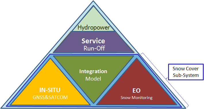
Service/ system concept
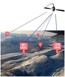
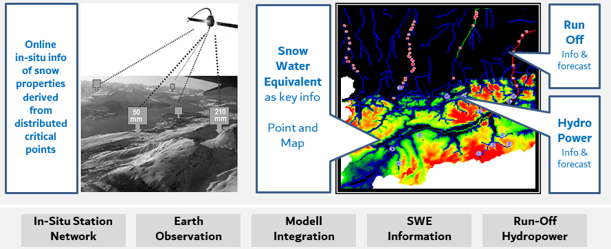
One of the key elements for the provision of Snow Information and Run-off Forecasts is the use of a novel in-situ hardware component for snow properties measurements.
Based on GNSS signals, the snow properties (e.g. the amount of water stored in the snow cover (=snow water equivalent) and the status of the snow (liquid water content)) can be retrieved by an autonomous operating, easy installable, maintenance free and low cost design sensor.
Satcom capabilities of the sensor system support the distributed installation of the in-situ hardware in large and remote areas.
Enhanced by the existing technologies of EO snow monitoring (using e.g. Sentinel-1) and snow modeling (using a physically based land surface process model) a reliable, state of the art snow information system will be installed.
Based on the snow information run-off calculations and hydropower forecasts can be provided.
The GNSS measurement system was successfully enhanced and tested for soil moisture monitoring with agricultural applications.
Space Added Value
Within SnowSense three space components show their excellent potential for solving the specific users needs for snow monitoring:
While Earth Observation is an applied method to retrieve information from remote and large areas surfaces, the use of GNSS as source of information retrieval is novel technology.
Using the signals of existing GNSS satellites (e.g. GPS) the physical properties of the snow cover can be derived at the locations of the distributed in-situ stations.
Satcom, as growing component in M2M communications helps SnowSense to retrieve information from all distributed station locations.
Current Status
The Demo Project started in February 2015 and achieved its Final Review in November 2018.
The assimilation of GNSS in-situ snow measurements and the information from EO monitoring, using Sentinel-1, with focus on the detection of snow melting processes, had been integrated to the hydrological model.
Within the demonstration period all relevant information for customer use and decision making had been provided online:
- Snow Water Equivalent Maps
- Satellite Observations
- Snow Station Measurements
- Run-off values
- Amount of water stored as snow (hydropower potential)
- Forecasts
Within an CCN extension (2018-2019), the capabilities of the GNSS technology for soil moisture measurements in agriculture could be successfully demonstrated.
SnowSense Stations and the SnowSense Service are now commercially available. The SnowSense station technology is patent pending. SnowSense is registered trademark.