Objectives of the service
We provide a global service that provides information concerning wildlife and nature of every spot on the Earth. This is mostly done by monitoring the wildlife habitats with low/medium resolution images rather than spotting/tracking directly animals that would require expensive high-resolution images.
Based on objective and consistent data, we help our customers with improving their wildlife and nature conservation activities. We offer the following services:
- Baseline assessment to determine the current situation related to wildlife. Furthermore, we can keep monitoring an area to provide the needed information on a quarterly or yearly basis.
- Historical assessment to identify relevant trends concerning the environment and wildlife.
- Implementation Advice. Based on our baseline- and historical assessments, we provide implementation advice to help with wildlife management.
- Crisis Prevention Plan. The information that we provide is input to prevent crisis related to wildlife management.
Users and their needs
Users:
- National governments and local governments
- Destination Management Companies
- NGO and/or non-profits
- For-profit-business
- Universities
Needs:
- Historical data to determine the baseline situation
- Data to determine trends concerning the destination
- Data of remote areas including protective areas
- Constant flow of cost efficient data
- Data that provides an overview and context of the destination
- An objective data source
The service can be provided to any organisation on the globe.
Service/ system concept
Information delivered:
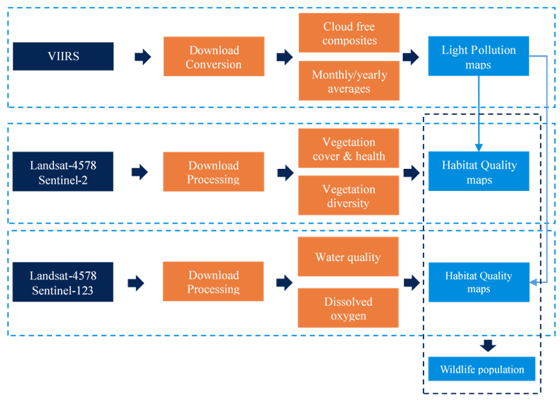
- Monitoring of light pollution: quantifying and mapping the intensity of night-time lights;
- Monitoring of land ecosystems: determine the quality of habitats;
- Monitoring of marine ecosystems: determine the quality of habitats;
- Habitat quality: translation of the habitat conditions into a quality indicator of the habitat.

Space Added Value
Space assets are key to realise our ambition to monitor habitats and protected areas worldwide. Satellites are monitoring the globe constantly. The data has been archived, which means that we can provide information about the same areas over multiple years. The advantage is that we can compare historical data and actual data. In that way, we can identify changes and trends, which provides information related to protective areas and natural habitats.
Earth observation satellites and satellite navigation provide high-value data globally, which enables us to serve customers in any place on Earth. Many satellites are publicly financed and provide the raw data for free. We use as much as possible this free data, which we will process to make it useful for protected areas and natural habitats.
Current Status
The kick-start activity has been finalised successfully. We are currently implementing (commercial) contracts, are setting up partnerships, and are acquiring new contracts.


