Objectives of the service
S-2-3 is aimed at biodynamic monitoring of trees, that is, their health status and dynamic behaviour with respect to wind conditions. S-2-3 was created as a system for monitoring green areas of archaeological/monumental interest and nature reserves and has seen its application on two case studies representatives in this sense: The Colosseum Archaeological Park and the Metaponto Nature Reserve.
Why monitor trees? For at least three reasons:
-
To protect the environment,
-
To defend the beauty of tree, archaeological, monumental heritage,
-
Manage risks and avoid damage to people and property.
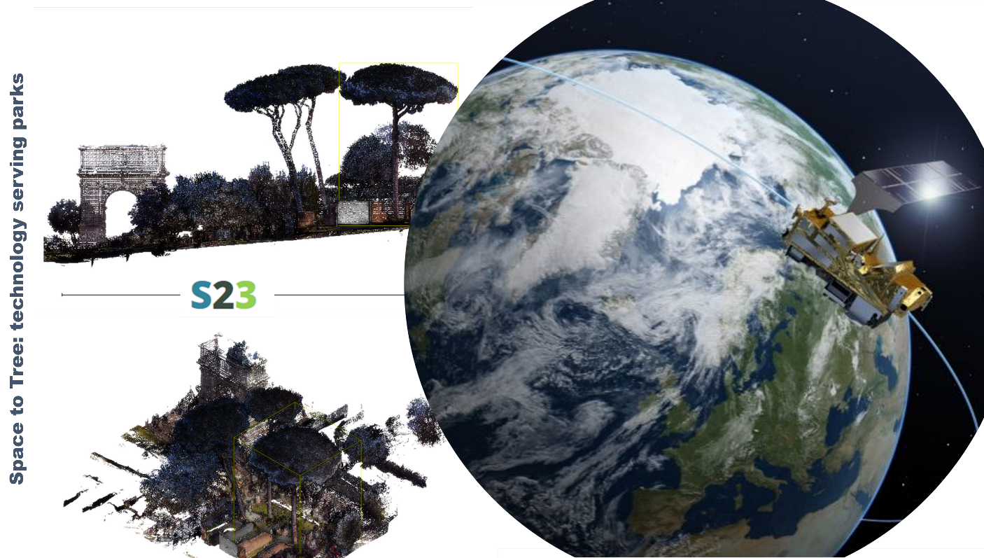
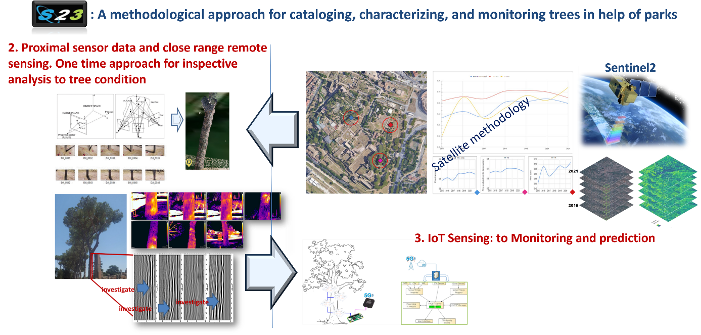
S-2-3 is also an interesting example of the synthesis of different technologies: satellite, proximal and close range remote sensing, and IoT-Sensing real time monitoring technology that uses 5G as its telecommunications system, this allows the system a multivariate and multiscale approach that can provide answers at different levels of detail from the area level (km) to the individual tree.
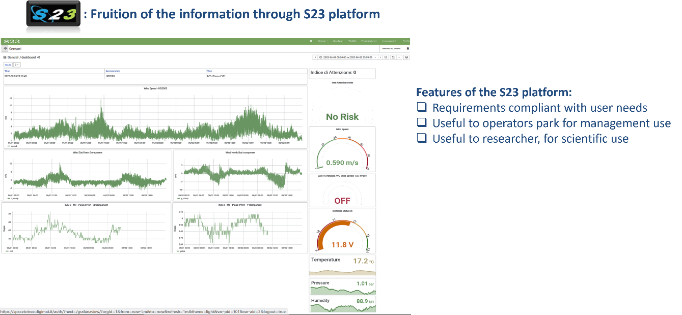
The WebGIS platform on which the data is available, has expandable and interoperable solution, and fits perfectly into the "Smart-City" model in which data and products are made usable in useful services for the community.
Users and their needs
S-2-3 is a system that has a dual vision:
-
it looks to park managers and operators who have an interest in using the platform's real-time and catalogue data for sustainable management of areas under protection,
-
it looks to research organizations that can download the data locally to use for scientific purposes through the use of third-party software.
S-2-3 currently serves:
1. the MiC (Ministero della Cultura) Autonomous Authority for the Colosseum Archaeological Park, specifically in the Roman Forum, an area where remediation has been carried out for pine trees infested with Toumeyella Parvicornis. This pest feeds on the plant causing first a desiccation of the foliage, leading onto extreme consequences on the stability of the trunk. Soon the system will be integrated to monitor five other archaeological parks besides the Colosseum, which are: Ostia Antica, Herculaneum, Paestum, Pompeii Campi Flegrei.
2. the Carabinieri Forestry Corps for the Metaponto Nature Reserve, a pine forest on the Ionian coast of Basilicata where the tree stability is threatened by both poor soil, high salinity levels due to proximity from the sea, and increasingly frequent extreme weather events in recent years.
Service/ system concept
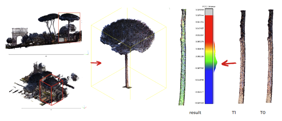
A multiscale methodological approach that relies on earth observation technologies and 5G as a telecommunication network to collect and send measurements to a webGIS platform. The instrument type used for tree inspection allows for a new non-invasive approach that avoids pulling or coring tests. S-2-3 allows trees to be catalogued and interventions to be planned based on the surveys conducted and diagnoses obtained from the measurements, continuously monitoring the dynamic behaviour of the tree with respect to wind values using an anemometer. The remote monitoring mode saves the time of personnel engaged in tree inspection, with targeted and consequently higher operational performance.
The S-2-3 platform is easy to use, expandable, and interoperable. The platform is suitable for park operators as it allows management use of information and for researchers who can download data locally for their own analyses done with third-party software. Videos demonstrating the service can be found on:
Space Added Value
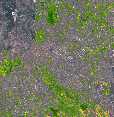
S-2-3 project uses satellite data made available by ESA as part of the Copernicus programme. In particular, time series of Sentinel-2 L2A data were used. The bands used were predominantly the Red and Near Infrared (NIR), i.e. bands 4 and 8 respectively. These were used to create time series of NDVI over time. The time-scale NDVI maps made it possible to observe trends in vegetation health over time, from 2017 to the present, and to create trends for each individual pixel over time. These values were then classified using artificial intelligence systems to create significant maps of the changes in the state of vegetation in the Colosseum Park and Metaponto Pinewood area. The S-2-3 project has the added value of addressing the pixel-by-pixel problem. In fact, thanks also to the size of the plants analysed, it was possible to observe individual pine trees, or groups of two pine trees, within the same pixel, so that the phenological trend of the individual plant could be well characterised. These data, obtained by satellite, the main tool in these analyses, were supported in a completely innovative way by ground truth and IoT analyses.
Current Status
S-2-3 project closed with the Final Review meeting on November 29, 2023. Case studies of the project can be found at: https://www.digimat.it/case_study/space-to-tree/
Results of the project were presented at: EIMA International Conference October 2021, Expo Dubai March 2022, MetroArcheo November 2023 Committee, International Museum day ICOM May 2023, Living lab within the Curia Giulia at the archaeological area of the Roman Forum (Archaeological Park of the Colosseum) November 2023.
Prime Contractor(s)