Objectives of the service
The main objective of the proposed service is to make safer the level crossing. Indeed, level crossing-related accident are the second cause of railway accident in EU. To do so, a dedicated system is conceived and designed for the achievement of this purpose. The end-users are railway infrastructure managers and road users. The main scopes are the following ones.
-
Assist railway infrastructure managers to better manage the monitoring and maintenance of level crossing finding effective solutions cheaper than the ones currently in use.
-
Assist road users at safely crossing railroad intersections providing a dedicated applications running on smart devices (i.e., smartphones).
-
Create a sort of connection between road users and railway managers. That is, road users can send feedback/encountered issues related to a level crossing to the railway managers through the application.
Users and their needs
The potential customers/users and respective needs are the following ones.
-
Railway infrastructure managers – the initial phase of the study has been characterized by a close collaboration with them (i.e., Italian, Norwegian, and German railway managers) where it emerged that they need a cost optimization of level crossing monitoring.
-
Road users – at the beginning of the study a survey has been spread over Italy and Europe, and the main needs have been collected. It emerged that they need higher safety when crossing railroad intersections and a route optimization service not to wait long time at the level crossings, if closed.
Service/ system concept
The provided services can be divided based on the end-user.
Railway infrastructure manager services are the following ones.
-
Remote monitoring of level crossings through the application of AI algorithms to Earth Observation images
-
Predictive maintenance of level crossings through their classification based on a dedicated risk scale.
Road user services are the following ones.
-
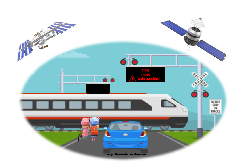
Monitoring of weather, road traffic and visibility at level crossings.
-
Dedicated applications with all information about level crossings.
-
Through the application
-
Warning about best behaviour while approaching and crossing level crossing.
-
Warning about eventual issues detected just before reaching a level crossing.
-
Possibility of sending feedback to railway managers and other road users about the status of the level crossing and/or presence of issues which have not been detected by the system.
-

Space Added Value
The considered space assets for the proposed solution are GNSS and Satellite EO technology. They are integral to provide unprecedented low-cost services able to drastically improve road user safety at level crossings.
-
GNSS technology, GNSS asset enables road users to share their PVT data with the system. Regarding road users’ PVT information, it is directly acquired from GNSS sensors installed on users’ electronic devices enabling system’s PVT services at low cost exploiting the hardware already integrated on users’ devices. In this way, the system can correctly send warning and notifications to road users as soon as they approach a level crossing.
-
Satellite EO technology, key element for the periodic monitoring of level crossing surroundings giving information about train visibility mainly influenced by vegetation growth, or other natural/artificial obstacles. The EO images used for this study are the ones provided by Sentinel provider.
Current Status
The feasibility study has been concluded in March 2025. The development of the services resulted technically and economically feasible. Additional prototyping activities regarding EO images processing are envisaged in view of the implementation of the services.
Prime Contractor(s)

Subcontractor(s)