
Objectives of the service
Use a bold image to start your webpage. It can be a photo or an infographic like this. Remember that you project webpage can be a powerful marketing tool.
This study addresses a critical gap in identifying and prioritizing energy efficiency improvements at the building level. The proposed Heat Loss Index (HLI) could help pinpoint structures with high thermal energy wastage, guiding efforts to retrofit these buildings for maximum impact.
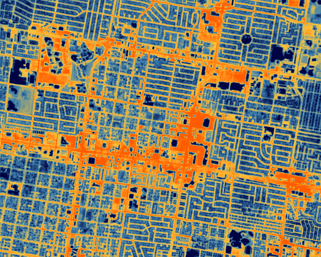
Traditional thermal surveys—whether conducted via drones or manual inspections—are costly and impractical at scale. Meanwhile, existing thermal satellite datasets, such as Landsat or ECOSTRESS, lack the resolution (70–100m) needed to assess individual buildings.
SatVu’s space-based approach changes the game. By leveraging high-resolution MWIR spectrum imagery with a ground sampling distance of 3.5m, SatVu will deliver unprecedented insights into urban energy loss—at a fraction of the cost of conventional methods.
“The Heat Loss Index has the potential to become a key benchmark for urban energy efficiency,” said Natalia Kuniewicz, Business Development Climate & Sustainability Lead at SatVu. “If successful, this initiative could transform how cities tackle energy waste, directly influencing retrofitting strategies, cutting emissions, and accelerating climate resilience.”
With global energy efficiency targets tightening and cities under pressure to meet ambitious net-zero goals, space-based thermal intelligence could be the breakthrough tool urban planners have been waiting for—helping to build greener, more sustainable cities.
Users and their needs
The Heat Loss Index (HLI) service targets several key user communities across the UK and Europe:
-
Consultancies: Built-environment advisors, facilities managers, and Carbon VRM companies seek actionable insights for client strategies and compliance reporting.
-
Value-Added Resellers: Companies like nexqt (France, Denmark, Netherlands), Ambue, and Landmark (UK) integrate HLI data to provide analysis, tools, and insights.
-
Financiers: Debt providers and equity investors require accurate thermal data for investment risk assessments and lending decisions.
-
Governments: Local councils (e.g., Leeds, Surrey, Glasgow) and national authorities use HLI for retrofitting and urban planning.
-
Energy Network Operators: Electricity and gas operators forecast heat demand to optimize asset loads.
-
Researchers: Academics in the UK, including UBDC, explore energy efficiency and urban heat impacts.
User Needs:
-
Accurate, high-resolution thermal data for decision-making.
-
Tailored insights for specific applications (e.g., retrofitting, carbon budgets).
-
Tools for integrating thermal data with existing models.
Challenges:
-
Ensuring data quality and resolution meet diverse user requirements.
-
Addressing integration with various user systems.
-
Building user trust and facilitating adoption through pilot studies and collaborations.
Targeted users are primarily in the UK, France, Denmark, and the Netherlands.
Service/ system concept
SatVu’s Heat Loss Index combines high-resolution thermal satellite imagery with advanced data analytics to identify buildings with significant thermal energy wastage. Using SatVu’s mid-wave infrared (MWIR) satellite imagery with a 3.5m GSD.
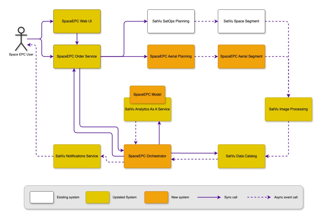
The process begins when a user places an order. The order service manages the request and triggers data collection. HotSat satellites capture thermal images of the selected area, and these images are stored in a data catalog. Once the images are available, the system runs an analysis using the satellite data combined with third-party datasets. When the analysis is complete, users receive a notification and can download the heat loss data or a detailed report in various formats.
The system follows an event-based architecture, ensuring automated, timely, and efficient processing. The web app and API allow users to interact with the system with little effort. Users can subscribe to being notified, for example via email, when their reports are ready.
Space Added Value
Existing thermal satellite datasets, such as Landsat or ECOSTRESS, have resolutions of 70–100m, making them unsuitable for evaluating individual building performance. SatVu's HotSat data, with its 3.5m resolution thermal infrared (TIR) imaging, will provide the highest commercially available detail, enabling precise assessment of urban building stock. This capability fills a critical gap, as traditional methods—like drone surveys or manual inspections—are too costly and impractical for city-wide evaluations.Sat
Vu’s future constellation of 10 satellites will offer unmatched temporal coverage of high-resolution mid-wave infrared (MWIR) imagery. This allows for the capture of temporal patterns in energy dissipation, providing insights into the “pattern of life” of buildings—something no competitor can currently achieve. When combined with socioeconomic data, such as energy poverty metrics, this capability transforms thermal imaging into a strategic tool for evidence-based policymaking.
The feasibility study is performed using aerial imagery downgraded to 3.5m GSD, mirroring the expected thermal imagery from SatVu’s satellites. By combining high spatial and temporal resolution with scalable city-wide coverage, SatVu’s space assets provide unique, actionable insights for urban planners and policymakers, far surpassing existing technologies in both accuracy and usability. This approach revolutionizes energy efficiency evaluations and supports impactful retrofitting decisions.
Current Status
The project has reached the Final Review with all technical and commercial objectives achieved. UBDC has successfully developed and validated a Heat Loss Index (HLI) using deep learning models, supported by aerial surveys and ground truth data from three UK cities. SatVu built a proof-of-concept web app and completed 20 stakeholder interviews and 10+ survey responses to validate market demand. Since the Business Case Review, a detailed technical roadmap has been co-developed and documented in Deliverable D3. An outline proposal for a follow-on ESA demonstration project has been prepared, and all final project deliverables have been submitted for review.
Prime Contractor(s)