Objectives of the service
Vertical52 empowers newsrooms and media houses with tools to access, analyze, and visualize geospatial data.
Through our Spacestack for Newsrooms project, we're developing essential functionalities tailored to user needs.
Whether it's integrating earth observation data into investigations or enhancing spatial narratives in news stories, our service addresses these demands.
As a Berlin-based company, Vertical52 has already secured early trial clients who've ordered high-resolution satellite data, conducted analytical investigations, and collaborated on data visualization projects.
In an ESA-funded feasibilita study, we examined the requirements to built a platform that will streamline the process from high-resolution satellite data ordering to spatial analysis and seamlessly integrate the chosen tech-stack into news media Content Management Systems (CMS). To realize this vision, Vertical52 has assembled a diverse team, including data scientists, remote sensing engineers, developers, and journalists. We aim to deliver a high-resolution data ordering platform prototype by the feasibility study's end and an end-to-end tool prototype by 2024.
With the European news media market exceeding 300 billion EUR, the demand for digital services is on the rise. Many media outlets are expected to invest in spatial visual content and analytics.
Our experienced founding team boasts a track record of recognition and awards in geospatial data analysis, with 50 years of combined expertise in the field.
Users and their needs
Journalists and NGOs in Europe require access to high-resolution satellite data and the necessary analytical tools for several critical reasons.
First and foremost, high-resolution satellite data provides a unique and valuable perspective on our planet. It allows journalists and NGOs to monitor and document various events and phenomena, including environmental changes, natural disasters, deforestation, urban development, and more. This visual evidence enhances the credibility and impact of their reports, making it easier to convey complex stories to the public.
Moreover, satellite data facilitates investigative journalism by uncovering hidden truths and exposing wrongdoing. It helps shed light on issues like illegal mining, deforestation, human rights abuses, and environmental violations, enabling journalists and NGOs to hold responsible parties accountable.
Access to satellite data also empowers these organizations to conduct independent research and analysis. They can track trends over time, assess the effectiveness of policies and interventions, and contribute to evidence-based decision-making. This capability is invaluable in advocacy efforts, policy recommendations, and raising public awareness.
Furthermore, the ability to analyze satellite data in-house reduces reliance on external sources, ensuring data integrity and security. It offers greater flexibility and efficiency in reporting, allowing journalists and NGOs to respond swiftly to unfolding events and crises.
In summary, high-resolution satellite data and analysis tools are essential for journalists and NGOs because they provide unique insights, support investigative journalism, enable independent research, and enhance the impact of their work by delivering credible and compelling visual evidence to the public and policymakers.
Service/ system concept
Users will be able to order high resolution satellite data through vertical52 ordering app. Vertical52 will curate the most suitable images for the area and the issue in question, procuring the satellite data from different sources.
The images will be delivered into a spatial account of the user where the user has the ability to also overlay and cross-reference the satellite data with other spatial data-sources. The user will also be able to annotate the datasets and share it with other journalistic team members that work with him or her on a specific investigation.
Finally, the platform will enable the user to download some investigations straight into the CMS system of their newsrooms.
Space Added Value
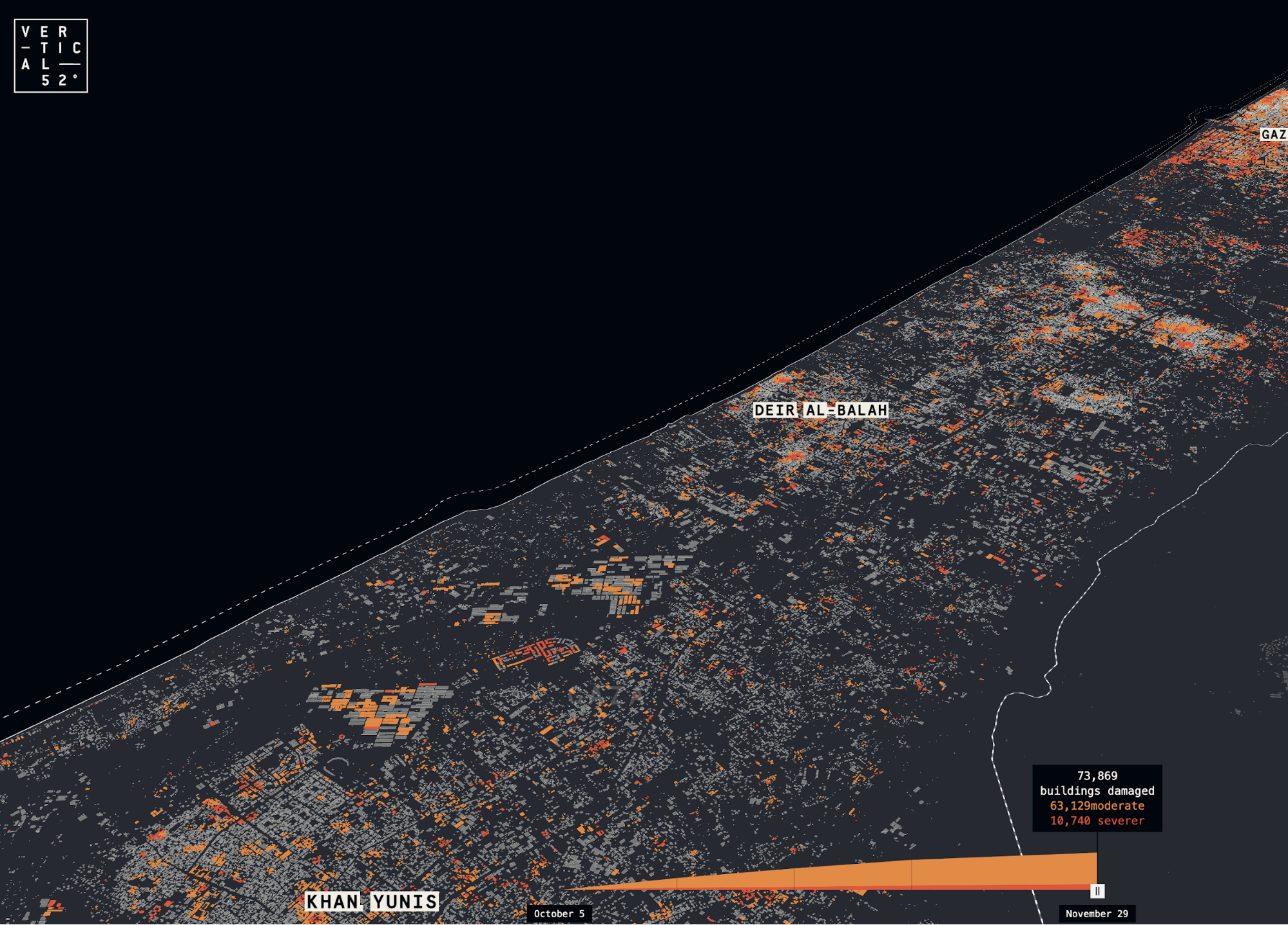
The Vertical52 application enables journalists to access various high-resolution commercial satellite images. Additionally, the platform visualizes diverse remote sensing analyses conducted by the Vertical52 team using publicly available satellite data and algorithms. These results are presented within a spatial environment, empowering journalists to visualize, annotate, and seamlessly publish the findings in their own Content Management Systems (CMS).
Current Status
After building several prototypes for data ordering and data visualisation (see above), the team is now working to enlist first newsroom customers in German-speaking Europe and is preparing to expand to other European countries.
Prime Contractor(s)