

Objectives of the service
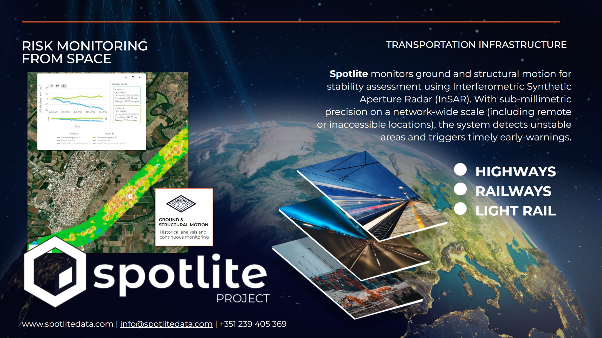
Through an online platform designed for the transportation infrastructure sector (road & rail), Spotlite provides monitoring ground and structural motion for stability assessment using satellite imagery. Interferometric Synthetic Aperture Radar (InSAR) allows for sub-millimetric precision on a network-wide scale (including remote or inaccessible locations). As such, the system is able to detect unstable areas and trigger timely early-warnings, so that preventive measures can be adopted before catastrophic failures occur. These actionable insights can help infrastructure operators and managers to optimise maintenance strategies and budgets, lower operational costs and increase the overall safety of the operation, avoiding damages and losses. The platform also provides maintenance management, reporting and tasking tools, centralising maintenance planning and documentation. These are associated with a 3D Asset Information Management (AIM) system, integrating satellite data with live data feeds from local IoT (Internet of Things) sensors, allowing for a richer understanding and characterization of structural behaviours.
Users and their needs
Spotlite is designed for maintenance operators and infrastructure managers in the transportation industry (both for the road and the rail sectors). Operators and managers need:
-
Constant and updated information on the structural stability over the entire extension of their networks and assets. Ground and slope movements may trigger catastrophic failures, resulting in damages, losses and interruptions of service.
-
When a critical risk is detected, users need an early-warning system to automatically issue alerts, so that the adequate preventive and corrective measures can be timely implemented.
-
Information on the evolution of structural stability and surface movements over time, to better assess risks, identify trends and predict occurrences.
-
Centralised platform to plan maintenance activities, aggregate documentation and generate reports.
The team is already working with important players in the target industry, such as Egis, and currently the solution has pilot applications in Portugal and Turkey. Other applications in Europe are being discussed.
Service/ system concept
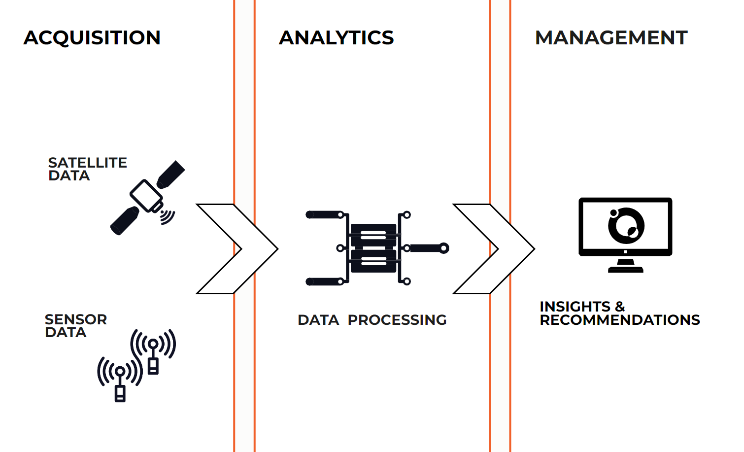
Spotlite uses an online platform to deliver analytics and insights on surface movements, including ground subsidence or slope instability. This data is obtained by processing radar imagery from orbiting satellites, covering the entire transportation network. Spotlite not only provides a periodical and continuous monitoring of these geotechnical risks, but it is also able to provide historical information on these behaviours, using archive data, to identify trends over time. To complement this analysis, the system is able to integrate satellite and sensor data. Spotlite centralises in a single platform a comprehensive management toolset that includes early-warning, reporting and tasking systems, as well as 3D digital environments for asset management and visualisation.
Space Added Value
Spotlite is a remote sensing risk monitoring solution, using Earth Observation (EO) satellites as its main data source. Ground and structural motion is measured using Synthetic Aperture Radar (SAR) data, from radar sensors equipped on satellites orbiting the planet. The use of these satellites means that (unlike field sensors that can only provide data on very specific points of the
infrastructure, and have high installation costs) the system is able to analyse the infrastructure network in its entirety. For the moment, Spotlite has been using the Copernicus Sentinel-1 mission as its primary SAR data source.
Current Status
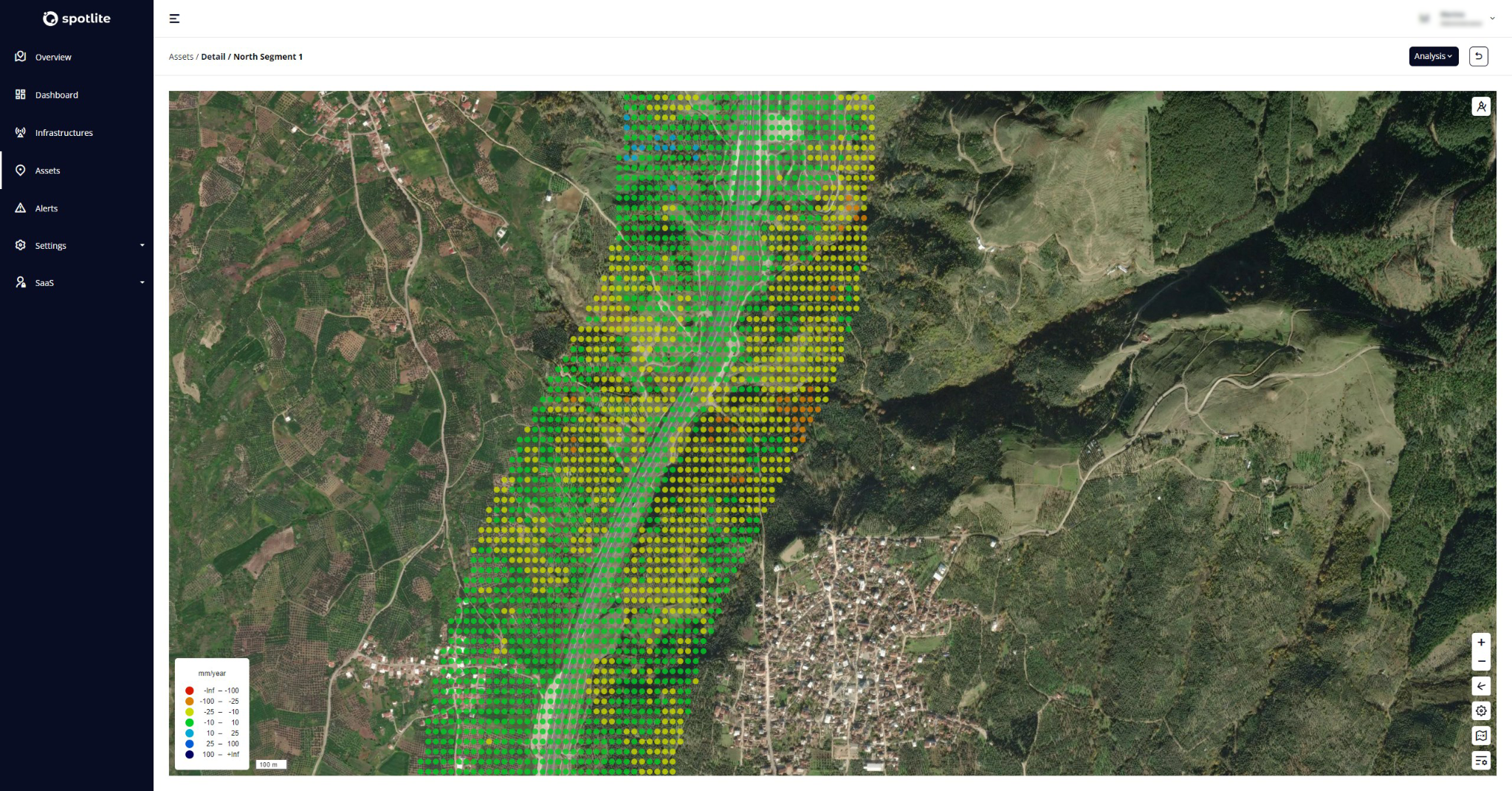
The project was successfully concluded, resulting in a functional online platform able to monitor geohazards threatening the structural integrity and stability of transportation infrastructure, using EO data. The development of these tools was carried out in close contact with pilot users from different industries, with implementation in different real-world scenarios. These pilot applications were carried out together with Egis in Greece and Turkey (GİİB) for the road infrastructure sector, and a smaller pilot application for the railway sector in Portugal, carried out with Infraestruturas de Portugal (IP). Moreover, in the case of the pilot application in Turkey, a first integration of 3D digital twins for asset management was also developed, as well as an experimental application of the solution to assess the impacts on the infrastructure of the February 2023 earthquake that impacted Turkey and Syria. All these tasks allowed for the validation of the technical aspects of the ground motion monitoring solution based on InSAR analysis, the asset management tools and early-warning system, the UX and UI of the online platform, as well as the proposed business model and the future scalability of its implementation in additional geographies. Towards this goal, several demonstrations of the solution to specialised audiences were carried out in various countries in Europe, Asia, Africa and Latin America.