Objectives of the service
SUMO is a service for planning and monitoring of marine operations for offshore wind farms.
These operations include installation of foundations, turbines, piles, and cables as well as service inspection visits and scheduled and corrective repairs. Due to the wind farm locations weather and sea (metoceanic) conditions are harsh so identifying opportunities to carry out the activities can be difficult. Up to date, accurate forecasts enable better planning and successful planning delivers large savings.
Carrying out offshore operations requires coordination of many teams and vessels. The service supports these activities by integrating diverse information to allow the monitoring and forecasting of metoceanic conditions and tracking of the locations of vessels and personnel involved.
Construction activities involve expensive vessels and so delays to work are to be avoided. Maintenance activities involve a loss of power generation, and therefore minimising the maintenance time also provides a direct saving to the users.
This service enables the management and coordination of construction, operations and maintenance. It is developed with a reference customer, Scottish Power Renewables who are assisting by carrying out an offshore demonstration of the service in their operational environment.
Users and their needs
The users are the staff responsible for the management and coordination of offshore wind farm operations. These operations are managed by a team of Marine Coordinators. They work in shifts and must hand off the activities to each other. They need support for:
- Making judgements about the priority of activities based on scheduled and unscheduled workload and weather windows. These plans are then reviewed and the latest information is used to decide exact scheduling and resource allocation.
- Monitoring of the locations of all vessels and personnel within the vicinity of the wind farm site. This includes the tracking of people entering and exiting the wind turbines. Current swipe card readers installed in wind turbines make use of GPRS/3G and there are issues with mobile signal coverage.
There are particular challenges due to the location of offshore wind farms. Firstly, they are located based on wind availability criteria, which is directly correlated with bad marine weather conditions. Secondly, they are often near areas with large volumes of marine traffic (such as ports). This means close tracking of all vessels in the area is required.
Worldwide
Service/ system concept
SUMO is a tool for planning and monitoring a wide range of marine operations. It allows a team of users to find time slots and resources which allow them to carry out the complex tasks of constructing, operating and maintaining an offshore windfarm.
It is a service integrating: specifically configured high resolution short term metoceanic forecasts, longer range forecast products, information about sea state conditions, location of vessels and workers.
The metoceanic parameters include:
- Wave height, direction and period
- Wind
- Sea surface and atmospheric temperature
- Currents
- Precipitation
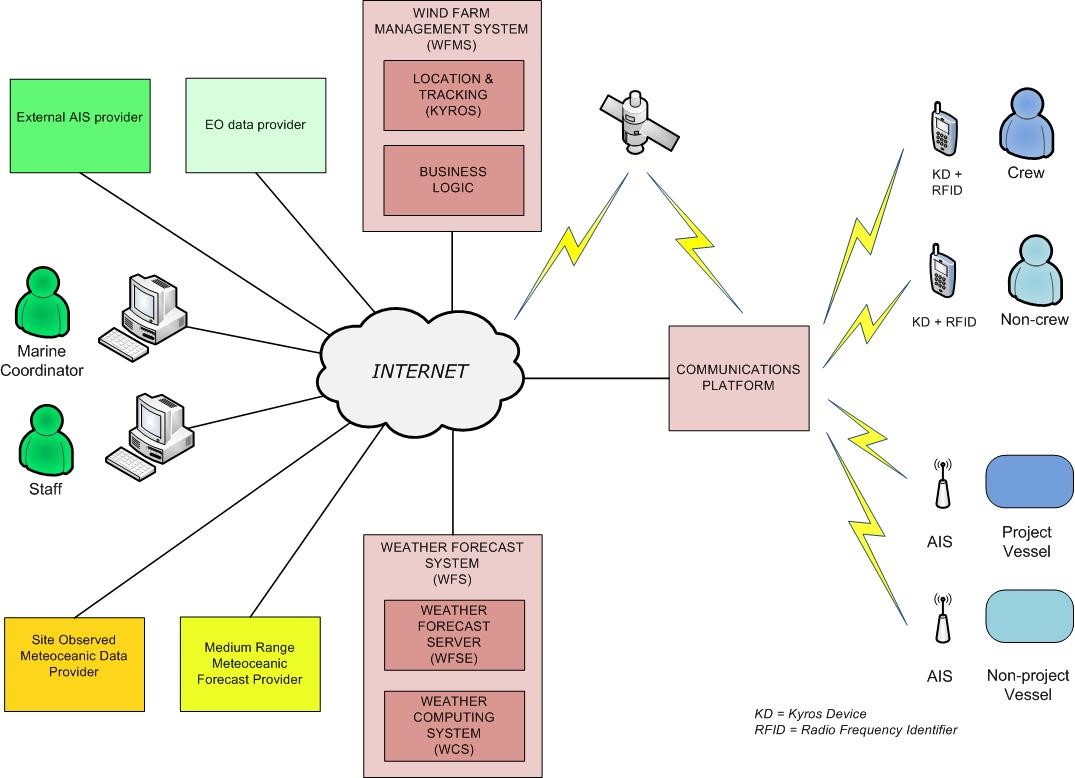
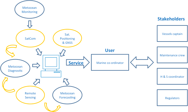
The sources of location information include AIS (Automatic Identification System) for vessels and GNSS (Global Navigation Satellite System) for individuals.
An Onshore Control Centre receives these sources of data and integrates it into decision support and forecasting tools.
A visual interface integrates the data enabling Marine Coordinators to improve management, logistics and Health & Safety during construction and maintenance. It enables improved efficiency in planning and also provides continuous updates on the latest conditions, forecasts and locations. It can also provide further support for dealing with emergency situations such as damage to a vessel or offshore structure.
Space Added Value
SUMO uses a variety of space based assets for sensing, communications and location services.
Satellite Positioning and GNSS is used for locating key personnel involved in operational activities. To achieve real time location reporting satellite positioning will be combined with satellite communications. These are used together with the AIS information on vessel location to give accurate information on the location of personnel.
Satellite communications will be used to send data from a network of RFID swipe card readers and an AIS receiver to the Onshore Control Centre. Data will then be made available for use by decision support and/or forecasting tools which will enable Marine Coordinators to improve control of the wind farm logistics and Health & Safety (H&S).
Satellite Earth Observation information complements the diagnostic of metoceanic conditions surrounding the wind farm and contributes to the optimization of the configuration of the high resolution models that generate the short term metoceanic forecasts.
Current Status
SUMO is an IAP demonstration project and the user requirements were established with the reference customer, Scottish Power Renewables, and captured as a set of User Stories.
The project is completed and consortium members are now working on commercialisation plans.
Prime Contractor(s)