Objectives of the service
- Bridge the monitoring gap — replace 4-week manual sampling cycles with continuous, near-real-time water quality intelligence for surface water bodies
- Early HAB detection — provide automated harmful algal bloom risk scoring and early warning alerts at least 48 hours before blooms become visible
- Integrated decision support — combine Copernicus Sentinel-2 EO imagery, WAMO in-situ sensor data, and AI analytics into a single, actionable web platform
- Serve dual market segments — support public water authorities with regulatory compliance tools and private operators (gravel pit, industrial lakes) with ESG audit documentation
- Enable scalability — prove a cloud-based architecture that onboards new water bodies with minimal incremental cost
- Achieve commercial viability — secure signed service agreements with public and private sector customers before project end
Users and their needs
SWIM serves two primary user segments across Germany and Colombia.
Segment 1 — Public Water Authorities & Environmental Agencies Municipal and regional water authorities (IKT-Ost AöR, HLNUG, LfU Bavaria), bathing water supervisors, and environmental health regulators in Germany, with expansion to Colombia (Fundación con Vida). Core needs:
- Early HAB risk detection to enable preventive bathing site closures at least 48 hours before bloom events
- Risk-based lake prioritisation to reduce unnecessary and costly field inspections
- Automated, traceable regulatory reporting compliant with the EU Bathing Water Directive and national standards
- Standardised, explainable risk indicators trusted by political bodies and the public
- Low-maintenance, high-availability monitoring infrastructure with remote diagnostics
Segment 2 — Private Water Body Operators Gravel pit and industrial lake operators (Heidelberg Materials, K.W. Hardt GmbH) managing restoration and post-industrial water bodies. Core needs:
- Continuous, auditable monitoring aligned with environmental permit obligations
- Quantified, audit-ready evidence of ecological improvement from Nature-based Solutions (NbS) for CSRD and ESG reporting
- Early eutrophication and HAB risk warnings to prevent environmental incidents and reputational damage
- Open API interoperability with corporate IT and EHS reporting systems
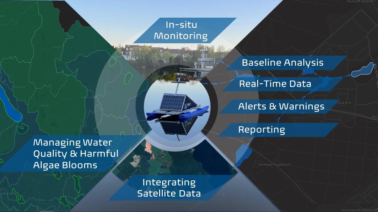
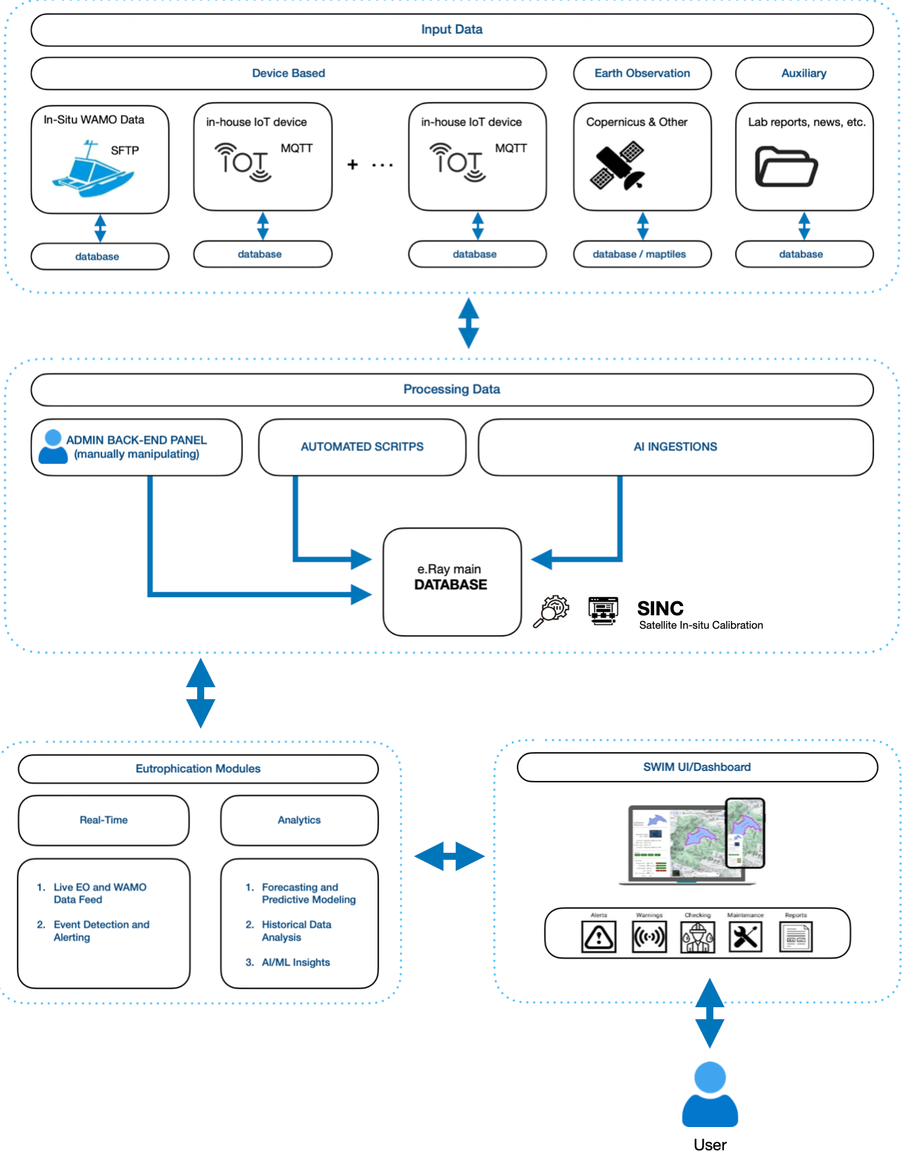
Service/ system concept
SWIM delivers real-time water quality intelligence through a four-layer architecture integrating nine subsystems.
- Layer 1 — Field Sensing: WAMO IoT buoys measure 14+ parameters every ≤5 minutes via LTE/Wi-Fi/SATCOM with RTK-GNSS (Galileo) positioning. Sentinel-2, EnMAP and SWOT provide automated EO acquisition via CREODIAS API within 3 hours of overpass. Auxiliary inputs (lab reports, news feeds) complete the input layer.
- Layer 2 — Backend Processing: Inputs converge into the e.Ray main database via automated scripts, AI ingestion pipelines and manual admin intervention. The OPIE Engine handles EO transformation; the SINC Calibration Engine fuses satellite and in-situ data for site-specific accuracy. e.WAI AI agent modules deliver bloom risk scoring, anomaly detection and natural language recommendations. Infrastructure is cloud-hosted on Frankfurt Tier-III servers with SATCOM backup for Colombia.
- Layer 3 — Service Delivery: The Eutrophication Module operates in Real-Time mode (live data feed, event detection) and Analytics mode (forecasting, historical analysis, AI/ML insights). An open RESTful API (WMS/WFS) enables municipal IT integration.
- Layer 4 — User Access: The SWIM dashboard delivers Alerts, Warnings, Checking, Maintenance and automated WFD/Bathing Water Directive-compliant Reports.
Space Added Value
Conventional water monitoring relies on point-based field sampling — spatially blind, reactive and too slow to prevent harmful algal bloom (HAB) events. SWIM resolves this through three integrated space assets that are architecturally essential, not supplementary:
- Earth Observation — Sentinel-2 : Provides whole-lake spatial mapping at 10m resolution with a 5-day revisit cycle via the CREODIAS API, delivering lake-wide chlorophyll-a, turbidity and cyanobacterial indices impossible to replicate with fixed sensors. EnMAP hyperspectral data enables advanced algal pigment detection; SWOT provides precise water surface elevation. Six years of historical EO baseline underpin long-term trend analysis. EO-derived outputs are fused with WAMO in-situ measurements through the SINC calibration engine for site-specific accuracy
- Satellite Navigation — RTK-GNSS/Galileo : Integrated within each WAMO unit, providing centimetre-level water level measurements and accurate geotagging of every sensor telemetry packet
- Satellite Communication — SATCOM : Backup connectivity channel for remote deployments (Colombia reservoirs, isolated German lake sites) where LTE coverage is unavailable, ensuring continuous data transmission to the Frankfurt backend
Without EO, SWIM is reduced to point measurements with no spatial context. Sentinel-2 delivers the early spatial bloom signatures detectable days before fixed sensor thresholds trigger that make preventive intervention possible.
Current Status
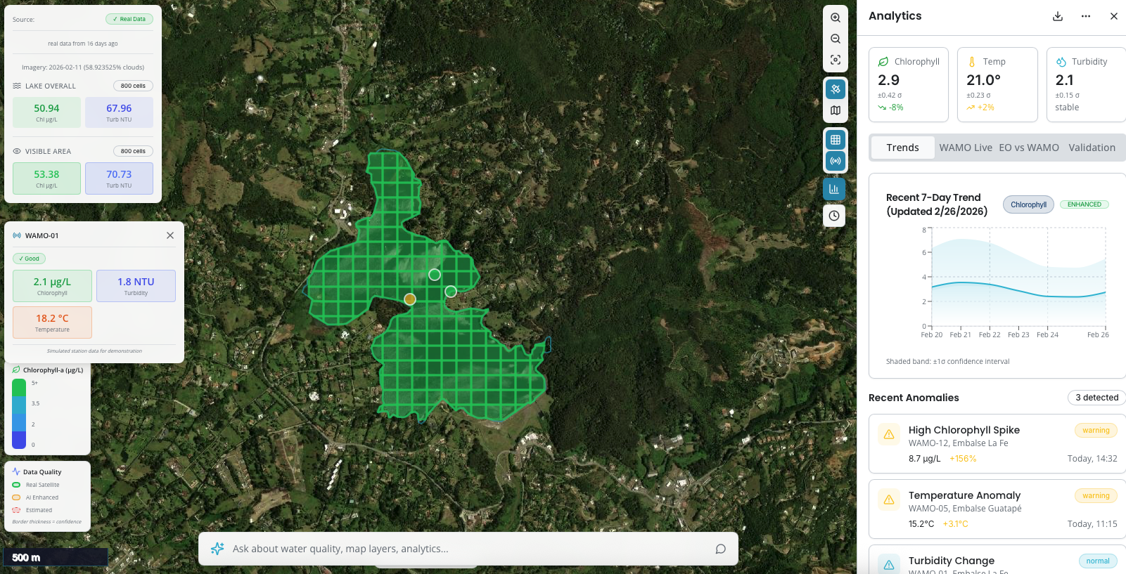
Twenty WAMO monitoring stations have been successfully deployed across water bodies in Mecklenburg-Vorpommern, Germany, with a first unit also operational in Colombia in collaboration with Fundación con Vida — marking a significant step in the international rollout of the service. The first functional version of the SWIM dashboard, featuring real-time WAMO sensor data and Sentinel-2 Earth Observation integration, has been finalised and validated with pilot partner IKT-Ost AöR, with cloud infrastructure fully operational. The project is also in advanced discussions with private sector gravel pit operators for further deployments. The project is on track, driven by strong interest from both public and private sector stakeholders.
Prime Contractor(s)