Objectives of the service
Marine Protected Areas (MPAs) deserve an extremely accurate care of their ecosystem and for this purpose they often impose navigation restrictions (speed limits, entrance), but controls are costly and extremely difficult to exercise.
Sympa provides tourists with advanced location based services that transform a park visit in a pleasure experience, with the potential advantage of boosting the local and often rural economy, and enabling at the same time the monitoring and control of vessels inside the Protected Area to the benefit of marine resources conservation.
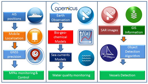
The preservation of sea biological resources is completed in Sympa by the provision of a daily service of “water quality” parameters. This is possible thanks to the innovative usage of Remote Sensing data integrated in a biogeochemical and hydrodynamic models capable of forecasting the capability of regeneration of the sea and to provide essential water quality indicators.
Sympa monitoring capabilities are completed using Satellite images to detect illegal ships.
The “Vessel detection” algorithm is capable of identifying objects on the sea surface. This service has the double vantage to deter illegal entrance, and to prove the actual monitoring capability of the system.
Users and their needs
Coastal zones are among the most productive areas in the world and have always attracted humans and human activities.
In order to further promote sustainable development of coastal zones, the European Commission adopted a Directive establishing a framework for maritime spatial planning and integrated coastal management.
In this framework Marine Protected Areas (MPA) management organisations are working for improving their capability for controlling and some cases limiting, the access to restricted areas.
MPAs authorities seek also to foster the economic and social wellbeing of local communities. In other words they are also in charge of promoting sustainable economic and social development of the local communities. Tourism creates jobs and money for local people, but also causes pollution, traffic, erosion and other problems. The convergence of objectives is desirable to avoid conflicts between the local community and the MPAs management.
Sympa responds to the monitoring needs of MPAs to both maritime activities, and water quality parameters.
Sympa supports the development of local economic activities the matching the supply and demand of services.
Service/ system concept
The modularity of Sympa architecture provides a web-based model with multi-tenancy bases platform. Different applications share architecture to get great benefit from the economy of scale.
The services shall be adapted to:
• different users’ needs: control, leisure, commerce, guidance
• different application scenarios: Marine Protected Areas (MPAs), harbours or marinas.
The service provision is based on low-intrusive tracking and tracing of private and commercial vessels within marine protected areas in the coastal areas.
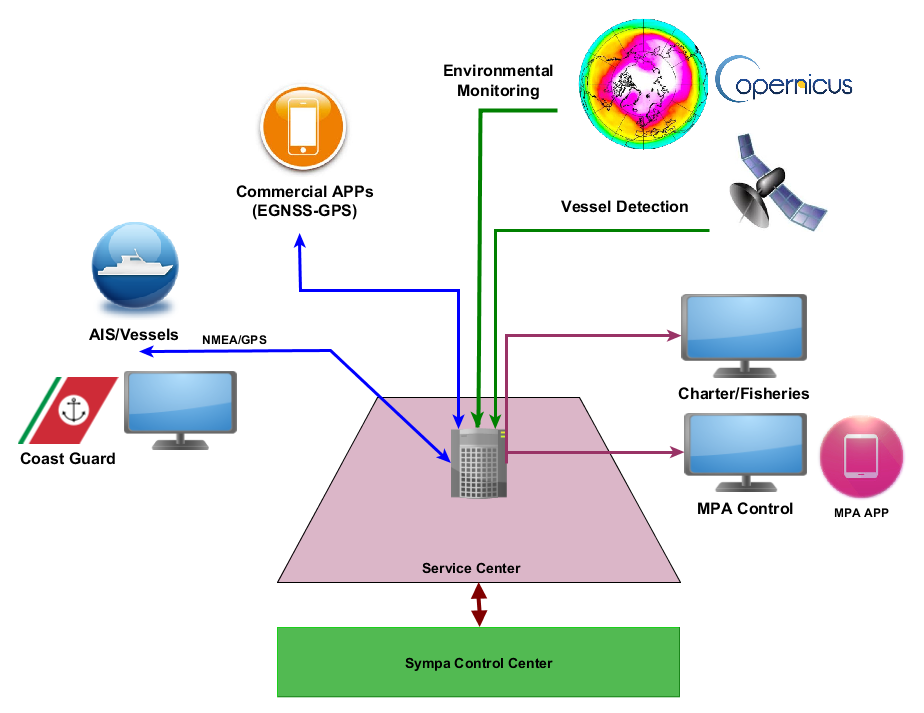
The IT infrastructure is composed of the following sub-systems:
- A Control System to monitor the performance and assure the correct working of the system.
- A Service Centre managed by MPA Authority and accessible also to the charters/fisheries companies.
- A bundle of commercial applications (APPs) available for installation on mass market devices, connected to the Service and Control Centre.

Sympa services include:
- Monitoring and control for MPAs.
- Fleet monitoring to Charters Companies and Fisheries.
- Vessel Detection using SAR images and target detection algorithm in order to support the supervision of the area and detection of illegal ships.
- Traffic Light which is based on biogeochemical and hydrodynamic models in order to obtain water quality indicators.
- Boat2boat ecommerce and services to tourists.
Space Added Value
Vessel localization is fundamental for the monitoring and control of Marine Protected areas; this is possible by exploiting AIS and GNSS positions provided by the location based services (such as catering and boat rental service) to tourists, charter companies, and fisheries.
Sympa offers an innovative service to assess the quality of sea water (Traffic Light Service). This is performed by integrating high resolution satellite images coming from Copernicus with ad hoc biogeochemical models. This service is capable to detect and forecast dangerous conditions for the ecosystems.
Sentinel SAR images are used for the Vessel detection system, which discovers and identify defined targets in the sea.

Current Status
The Sympa Project is a follow-up of the FP7 funded MEDUSE Project involving all the consortium members, which has been successfully closed in September 2013 with a customised prototype demonstration at La Maddalena Marine National Park in Italy.
The Sympa demonstrator project kicked-off in February 2016.
The pilot phase has been conducted for the whole Summer 2018 with the participation of four Marine Protected Areas.
The project concluded in October 2018.


