Objectives of the service
Precision Farming aims at increasing productivity of agricultural cultivation via a more efficient utilization of natural and anthropogenic resources (land, seeds, fertilizers, plant protection agents and water). The objective of this activity was to develop and implement a set of cost-effective end-to-end Precision Farming services for winter wheat, maize and sugar beet that allow the farmer with little effort to adopt a comprehensive site-specific farming system.
Users and their needs
Targeted users are mainly arable farms in Germany and Eastern Europe, with a focus on winter wheat, maize and sugar beet. Traditionally, farming was an activity dedicated to the production of food for humans. In the last few years, the Energy Industry has also become an active player in the field of agriculture mainly due to the recent success of bio-fuels. Precision Farming requires an open mind regarding new technologies and their application, which is where agricultural machinery manufacturers come in. Also, younger farmers are starting to be aware of the business advantages that can be derived from new technologies.
Service/ system concept

The concept is the following: the farmer requests a service from the catalogue for a particular area that has to be located using Navigation Technologies. The service provider, based on the Navigation information and Earth Observation data, together with a land surface model, prepares the specific products. The farmer, based on the TalkingFields products, his personal experience as well as on Navigation information, plans and performs the necessary crop management measures in the specific location. In this way, every part of a field receives individual treatment, saving costs and improving the effective yield.
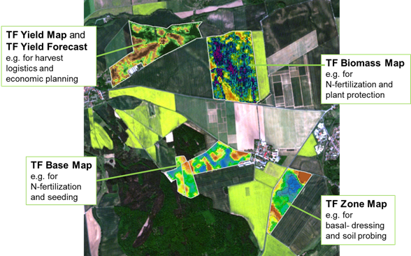
TalkingFields has successfully developed the following services and products:
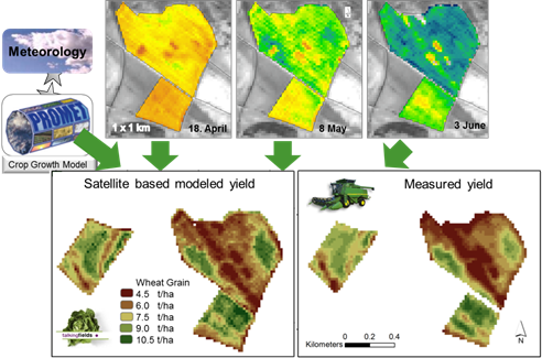
Technologically, the (in principle) daily provision of current biomass values to the farmer as well as the yield forecast are made possible by the assimilation of the crop information derived from EO satellites into a land surface model, which simulates daily growth under current weather conditions in a spatially distributed way and hourly time-steps during the whole season.

Space Added Value
For the TalkingFields services, the integrated use of Satellite Navigation and Earth Observation satellites is extremely important. The GNSS component provides the localization that enables farmers to conduct precision farming operations such as plant protection and fertilizer applications. Earth Observation satellites provide information about the crop status on all fields of a farm in one single snapshot. Satellite Communication makes service provision possible in areas where no terrestrial links are available.
Current Status
COMPLETED
TalkingFields has successfully concluded its Demo Study and is now operational. Major achievements include:
- Market roll-out for TF Base Map and TF Zone Map already achieved during demonstration phase.
- More than 55 000 ha service area for TF Base Map and TF Zone Map already processed.
- More than 60 customers have already ordered and paid for TalkingFields services. Orders have been processed from 8 countries: Germany, Russia, Denmark, Czech Republic, Poland, Latvia, Hungary and Kazakhstan.
- Strong market position in Germany due to PC Agrar customer base and combined offer with soil probing service of PC Agrar.


