
Objectives of the service
TIGRIS is a project by Spaceline Labs, designed to enhance capabilities for Earth Observation by providing high-resolution, persistent monitoring from the stratosphere. Many industries, including environmental agencies, infrastructure developers, and insurance firms, struggle with limited access to frequent, high-resolution imaging for critical areas of interest. Current solutions—satellite imaging, drones, and aerial surveys—often lack the necessary resolution, revisit rates, or affordability needed for effective monitoring.
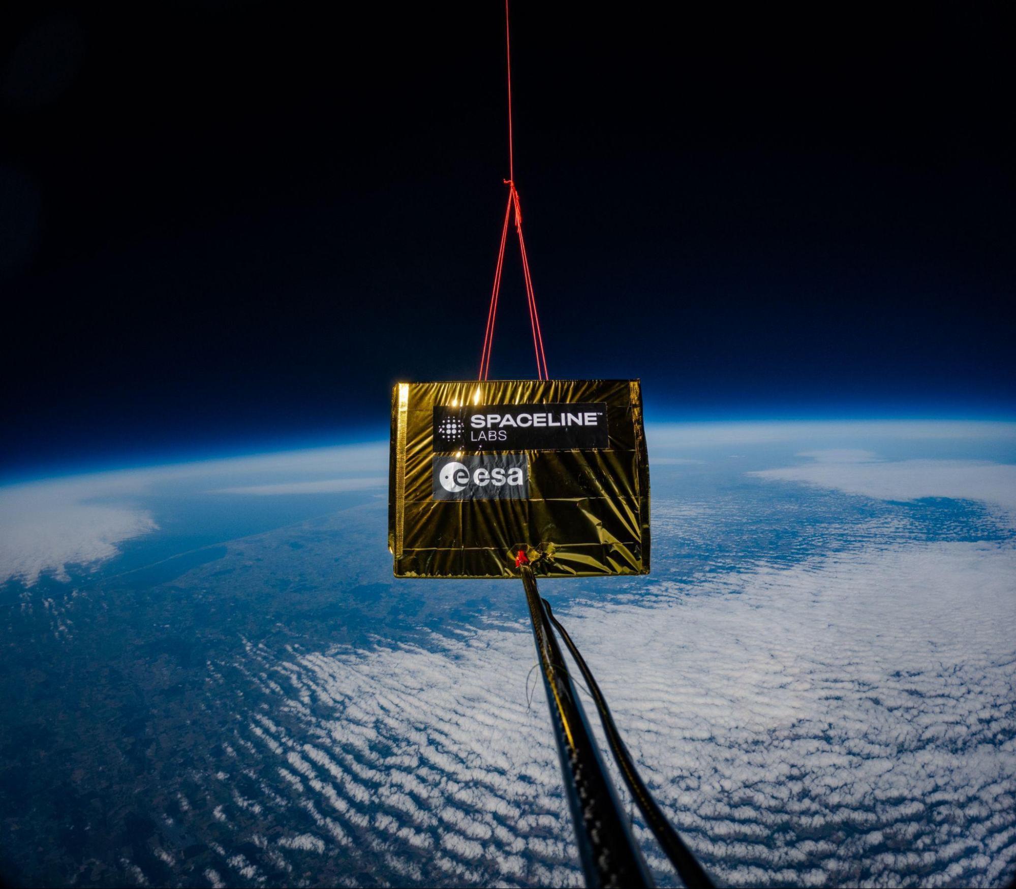
TIGRIS addresses these challenges by deploying High-Altitude Pseudo-Satellites (HAPS)—balloon-based platforms equipped with advanced imaging sensors. Positioned at approximately 20 kilometres altitude, these systems capture detailed, near real-time imagery with significantly higher resolution and more frequent revisits than traditional satellite systems.
This project aims to validate the service through collaboration with key partners - and future customers. The study refined the system capabilities, improved data processing, and laid the groundwork for demonstrating a scalable, subscription-based monitoring service. By combining stratospheric imaging from TIGRIS with orbiting satellite data, Spaceline Labs will provide actionable insights, ensuring better decision-making for these industries.
Users and their needs
TIGRIS is designed to serve key user communities in Europe.
The project focused specifically on three primary user groups, each with distinct needs and challenges:
-
Environmental Agencies
Needs:
Frequent, high-resolution RGB and hyperspectral imaging to monitor protected areas.
Improved classification of nature types for environmental compliance and biodiversity assessments.
Alternative to expensive and infrequent aerial surveys.
Challenges:
Ensuring high-resolution imaging across large, diverse landscapes.
Developing a cost-efficient, automated monitoring system.
-
Construction sites and Infrastructure Operators
Needs:
Continuous monitoring of large-scale construction projects.
Real-time imaging of marine-based operations.
High-accuracy data for contract enforcement and risk assessment.
Easy interpretation of insights through platform.
Challenges:
Delivering near real-time, persistent data over dynamic environments.
Integrating HAPS-based EO into existing engineering workflows.
-
Insurance & Risk Management
Needs:
Detailed post-disaster damage assessment for faster claims processing.
Fraud detection through automated change detection analytics.
Higher-resolution alternatives to low-frequency satellite imagery.
Challenges:
Optimizing data accuracy and availability for insurance risk modelling.
Ensuring rapid deployment after catastrophic events.
TIGRIS has been scoped toward these three specific segments. However, applications within crisis management and safety have arisen during the feasibility study phase and will be included in projects continuing from TIGRIS
Service/ system concept
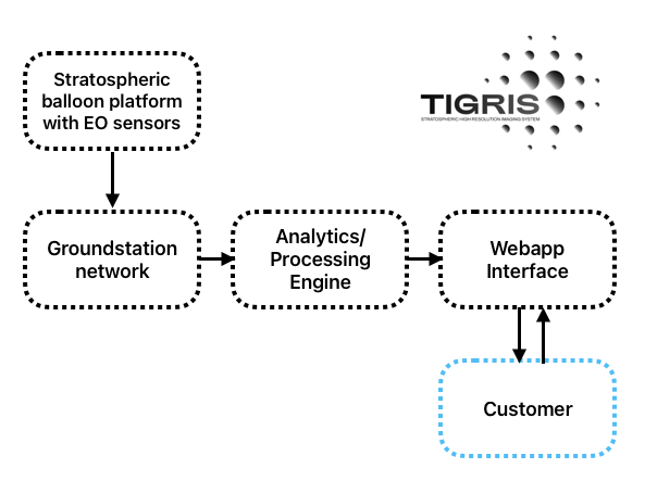
TIGRIS delivers detailed, real-time Earth Observation (EO) data to users through a secure, cloud-based platform.
The user gain access to:
-
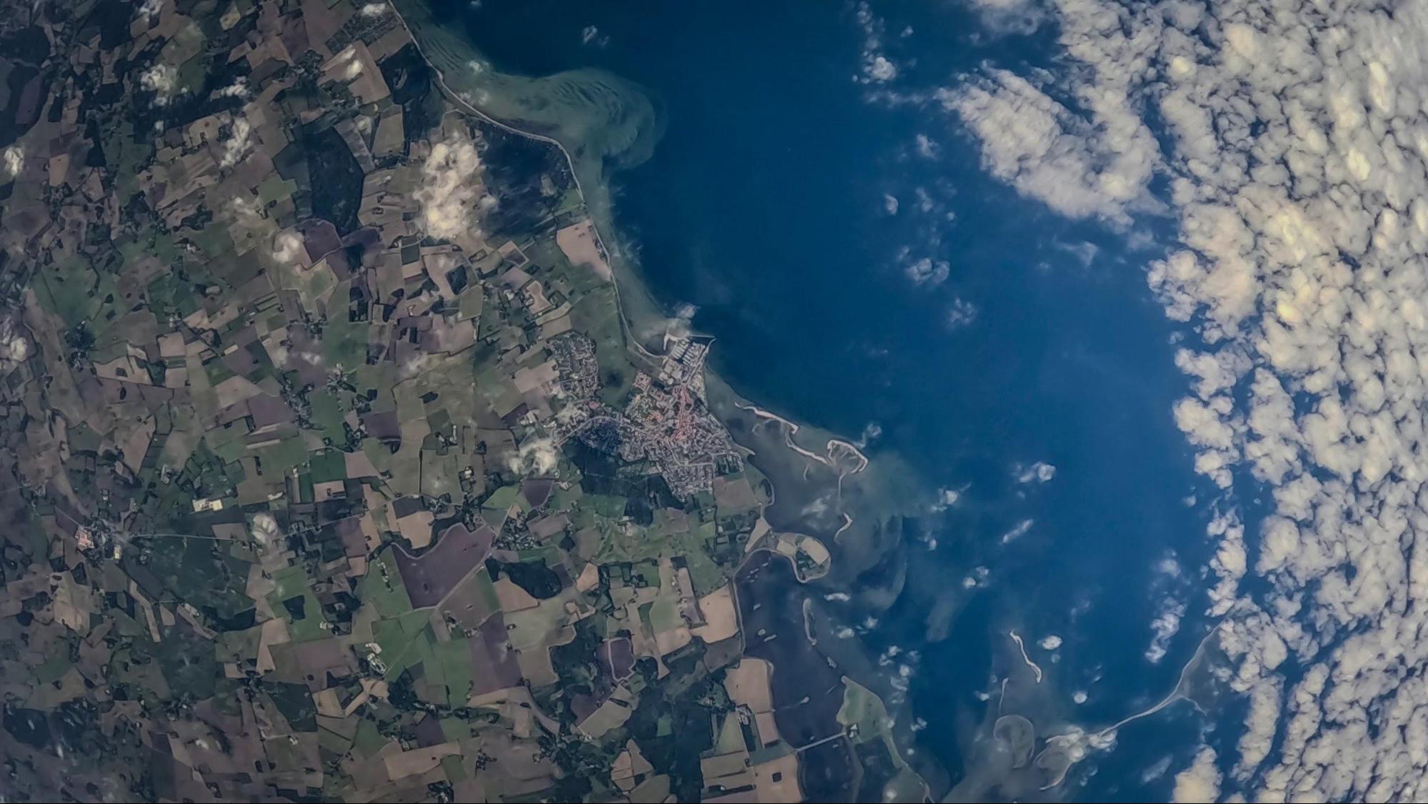
Sharp, detailed images of land and water areas, in better than 30 cm resolution.
-
Frequent flights providing real-time or scheduled monitoring of critical sites.
-
Custom analytics, such as environmental changes, infrastructure progress, or disaster impact.
-
Access from anywhere via an easy-to-use online platform.
The system is equipped with different payloads to provide the EO data needed and float at 18-25 km above Earth. They capture high-resolution images of key areas and transmit the data via satellite and ground stations. Thereafter, the data is processed and analysed to provide clear, actionable insights.
Users access the information through a secure web platform or API, enabling them to track changes, detect risks, and make data-driven decisions. By combining the station keeping with high quality imaging, TIGRIS provides faster, more detailed, and more flexible monitoring than satellites or traditional aerial surveys.
Space Added Value
TIGRIS leverages multiple space assets to enhance its Earth Observation (EO) capabilities:
GNSS Satellites: Used for stratospheric positioning and control inputs. Unlike ground-based navigation aids, GNSS functions well at 20 km altitude, improving georeferencing accuracy and positioning information, which is important to coordinate flights in the controlled airspace below 18km altitude.
Communication Satellites: Provides continuous, stable data transmission from TIGRIS to ground, even over remote areas. Unlike direct radio links, SatCom scales easily, enabling global operations. However, challenges remain for high bandwidth requirements.
EO Satellites: At a later stage this data can be used for data fusion and georeferencing.
Current Status
TIGRIS has successfully completed initial feasibility studies, technical validation, and user engagement activities. Key achievements include:
Successful stratospheric test flights, validating TIGRIS regulatory and operational feasibility as well as initial imaging capabilities.
Pilot project agreements established with multiple customers.
Market study completed, confirming strong demand for high-resolution, frequent EO data.
Currently, the team is preparing for further test flights, focusing on longer endurance and improved control. In parallel the payload team is maturing the imaging system to provide very high resolution imaging delivered through the cloud-based EO data platform, with planned beta demonstrations for early users in 2025.
Next steps include expanding pilot demonstrations and refining the commercial roadmap to support early service deployment.