
Objectives of the service
The TIKKA project objective is to support and improve the management of timber logging plans, which today requires long and expensive field visits during which the existing timber stock and site characteristics of the logging area are evaluated. Based on the collected information, a set of decisions is made with respect to the logging operation. This is the process behind a logging plan definition.
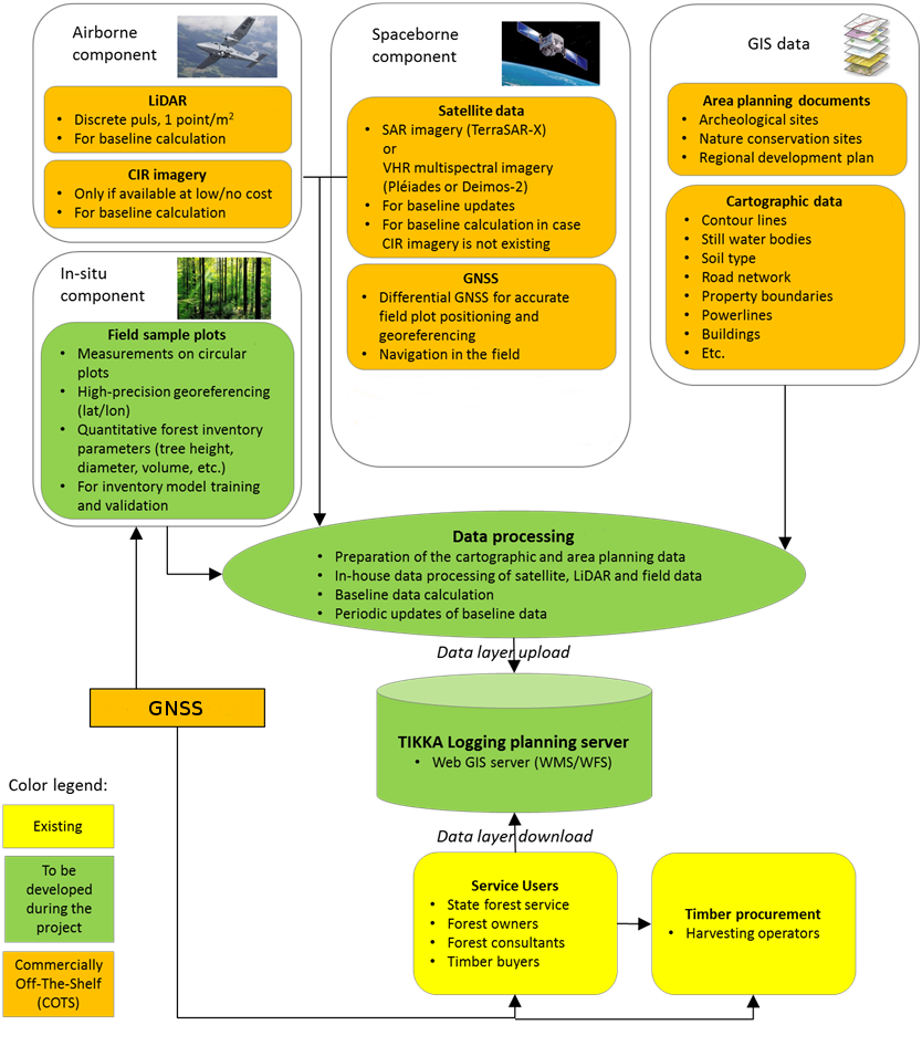
The TIKKA service increases the efficiency of planning activities, benefit from the integration of different data such as satellite remote sensing (in particular SAR and optical sensors), LiDAR scanning and GNSS data/measurements.
Based on state-of-the-art remote sensing and GIS methods, the service provides timely and accurate geo-referenced information about the forest environment and its surrounding topography. This information allows organizations and enterprises involved in the planning of timber logging operations to identify the most economically valuable areas of the timberland and to develop detailed logging plans. The data is available via a web portal and can be shared through OGC services (WMS, WFS, WMTS, WCS)
Users and their needs
As outcome of a market research activity, the service targets users part of the Forest segment (RSF Szczecin).
During the user requirements definition and the pilot demonstration the TIKKA service has been supported and validated by representatives of the Regional State Forest in Szczecin (Poland).
The current practice in The Polish State Forest regarding to the Logging plans is that all the tasks are done through lengthy field work.
As a based map the Forest Service uses the digital and topographic maps to do the forest inventory task. During those field measurements the data are collected as a text descriptions. In this method the average time of producing Logging plans per 1 ha is around is 1-2 days.
In Poland, the forestry regulation was made in 60’s therefore it does not take into account innovative technologies. Today, the State Forest is working on a new regulatory law where the Remote Sensing technology adoption will be recommended, especially during the operational and conceptual tasks.
LiDAR, packaged with field map databases and spatial datasets of environmental and ecological information as well as regional plans, is capable of providing the information needed for successful logging operation planning. The best benefit would be acquired if LiDAR was collected annually. However, this kind of collection cycle gets cost prohibited. The cycle of LiDAR collection for other purposes will vary in different countries, but seems to settle around 10 years in Poland and Scandinavia. The challenge related to logging operation planning is to update the information annually so that the logging operation planning activity can utilize the potential of up-to date information.
The User Needs identified are:
- Reduction of costs for preparing the logging plan.
- Up-to-date geo-referenced information layers that facilitate the development of logging plans indoors.
- Improvement of the current quality level of logging plans.
- Ability for the Users to utilize this information in their own GIS systems without the need of additional IT projects.
Service/ system concept
The TIKKA service allows to combine remote sensing (SAR), LIDAR, and GNSS to support the logging operation planning activities by the Polish State Forest users. Currently in Poland, logging plans are made in the field by walking through the target areas and evaluating the timber stock and site characteristics and defining the logging site boundary. Most of the required information for preparing logging plans is collected in the field while some data are manually derived from existing map and inventory data. The proposed service increases the efficiency and level of detail of the logging planning.
So far logging plans prepared by the state forest users in Poland are not yet based on LiDAR. This project demonstrated the application of advanced remote sensing technologies to the relevant decision makers in order to enhance the efficiency of the logging planning work. During recent years the awareness of existing cutting-edge technology for the forest sector has increased in Poland and a change in mentality is taking place. The coming years will bring a de-regulation and changing of the forest law where more advanced technologies will be recommended and possibly will become obligatory. However, the main players that form the target users of this service already exist. They already have the necessary GIS tools in place.
Space Added Value
The TIKKA service integrates LIDAR technology, EO/SAR satellite imageries and GNSS segment. The type of satellite data to be used during the preparation of the logging plans in forest depends on the site selection and the existing archived data for the site.
Although the forest inventory component of the service could be solely based on LiDAR and aerial imagery, there is a main obstacle in the availability of up-to-date LiDAR information. LiDAR provides an optimal mean to derive baseline forest inventory information on tree height, tree diameter, stem volume etc. However, to be timely, this information has to be less than 3-5 years old. LiDAR data will not be updated at such a rate, requiring space borne technology to update the areas logged after the base line data collection. LiDAR data is either complemented by available spectral imagery or alternatively by VHR satellite data. The spectral data is used to derive information on forest types (broadleaved vs. conifer) and species groups. The satellite-based updates address mainly significant changes in vegetation height (detection of potential cutting sites) which can be carried out very cost-efficiently using SAR imagery. However, the pre-condition for integrating satellite earth observation is the existence of the LiDAR-derived highly accurate and detailed digital terrain model (DTM) and timber inventory. Thus, the service and integrated algorithms rely on LiDAR only for establishing the baseline information (such as canopy height and quantitative timber parameters) including the DTM, and thereafter continue based on SAR imagery only. Alternatively, VHR satellite timeline pairs can be applied for these updates instead of SAR.
Larger changes in the vegetation surface (height) resulting from logging operations can be derived for example from TerraSAR-X data applying stereo-radargrammetry. This technology has shown to estimate tree height with an accuracy level that is sufficient for detecting significant changes in the canopy surface between two points in time. Smaller changes in vegetation height caused by tree growth cannot be derived from SAR data and thus will be estimated from the baseline inventory data using species-specific growth-models.
Current Status
The demonstration phase of the project was successfully completed in May 2017. During the conference that took place on 11 April 2017 in Pogorzelica, forest users provided a positive feedback acknowledging the TIKKA service success.
During the demonstration, the involved users had the possibility to evaluate the service accessing directly to the TIKKA web Portal:
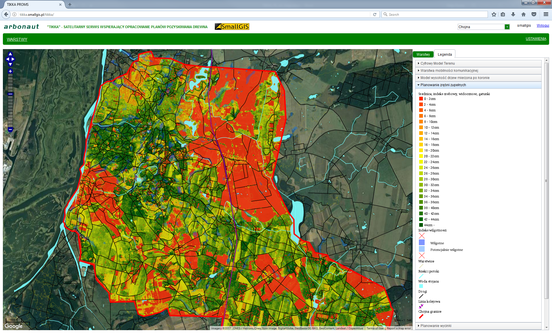
A part of web portal view of the tree diameter map.
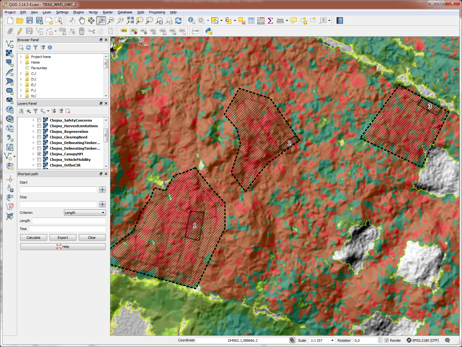
Creating a logging plan in Chojna area with QGIS using the TIKKA WMS service
The service is not only supporting the RSF users to perform more efficient and less expensive logging operations but it is also supporting and triggering the adoption of technologies such as Remote Sensing in vision of the new Polish forestry regulations.
Further development of the system is planned in subsequent stages of project.