Objectives of the service
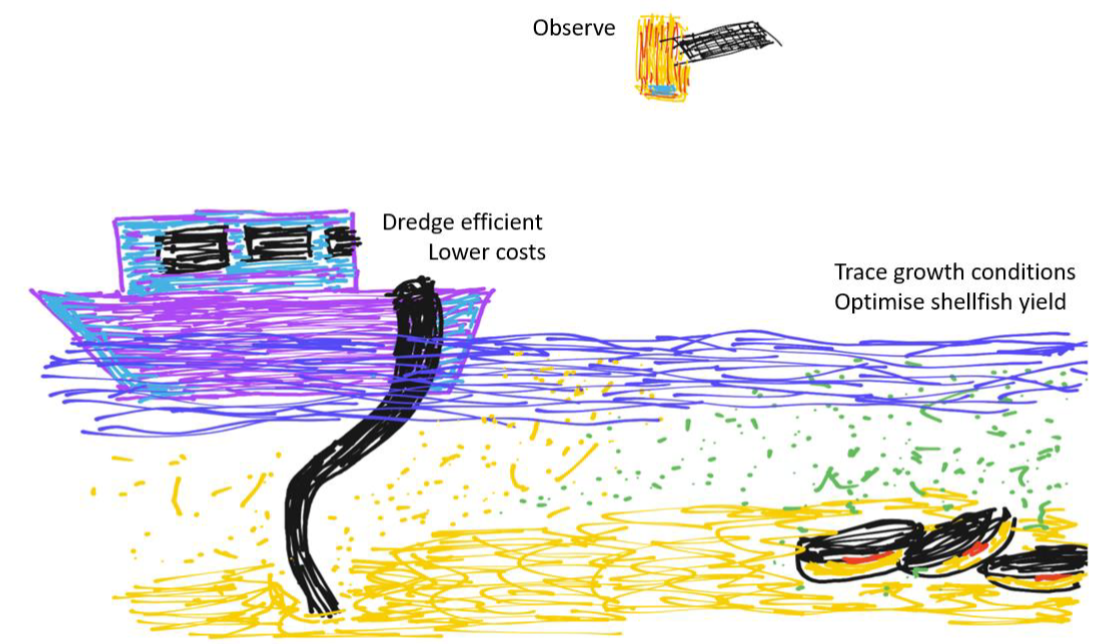
TRACTIONS will provide a near-real time, highly accurate mapping service of surface water transparency and primary production, for the dredging respectively the aquaculture markets on a subscription base.
TRACTIONS will help users to monitor dredging plumes up to multiple times a day, allowing port authorities and dredging companies to carry out their work without having to transport sediments over long distances and while respecting the requirements with regard to environmental thresholds.
TRACTIONS will provide the primary production information that is longed for in existing aquacultural growth models. This will allow aquaculture farmers to better plan the seeding, re-locating and harvesting their stock, especially in the more remote locations for which there is now barely any information available.
For both user markets TRACTIONS will therefore greatly increase the users efficiency with regard to shipping time, and therefore for man power, gasoline use and CO2 production.
Users and their needs
Dredging market: ports and dredging companies
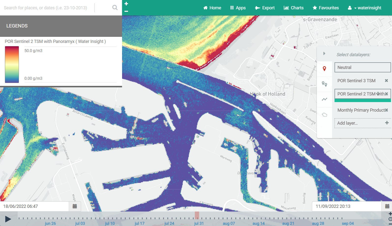
Involved user: Port of Rotterdam (PoR).
PoR needs to dredge the harbours and dispose the dredged materials. However, transporting the materials to pits in the North Sea is expensive and causes a lot of CO2 emission. A new method to slowly release dredged material and let it dissipate by the river and currents could save up to half of the transport costs and reduce CO2. Spatial monitoring of the materials is required to set up this method. Dredging companies need to spatially monitor their dredging plumes.
Needs to be covered by TRACTIONS:
-
Turbidity / suspended matter maps
-
VHR
-
Multiple times per day
Aquaculture market
Involved user: Roem van Yerseke (RvY).
Targeted users: worldwide
The shellfish production in the traditional areas in the Netherlands is decreasing, while sea food is seen as one of the most important protein sources of a (sustainable) future. RvY produces shellfish and wants to optimise production and harvest planning based on relevant data and models, to increase their profit for the traditional areas as well as for potentially new areas about which little is known about productivity. Monitoring Chl-a and transparency using EO data can provide the necessary insight in space and time. Calculating primary production and use it as input for modelling will enable producers to plan production, optimise yields and reduce losses.
Needs to be covered by TRACTIONS:
-
Primary production maps
Service/ system concept
TRACTIONS provides near real time, daily and for specific cases multiple times per day, calibrated maps of turbidity/transparency and primary production. This allows users in the dredging market to streamline their dredging activities, saving high costs, and the aquaculture market to more precisely model growth of their stock and use this to improve their trade.
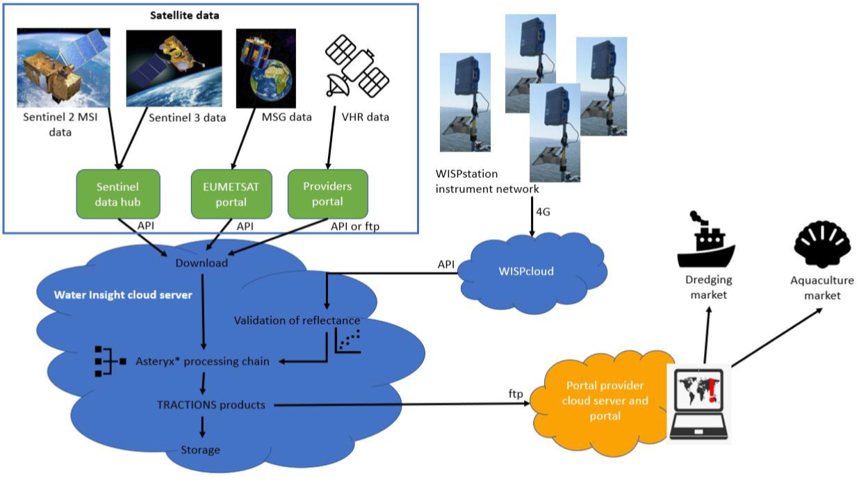
Regional and daily satellite data (Sentinel 2, 3, Meteosat and VHR) are downloaded to the Water Insight cloud server and processed, validated and converting to TRACTIONS products via the Asteryx* processing architecture.
For primary production calculation a new Asteryx* module will be developed based on scientific literature. Also for handling the VHR images WI will develop an additional module as part of Asteryx*.
The WISPstation instrument network of radiometric instruments installed on water bodies measure autonomous and semi-continuous the light reflected from the water and send it via 4G to the WISPcloud processor and database. The instrument network will be used for calibration/validation of the satellite reflectance and derived parameters.
TRACTIONS products are pushed to the portal. Customers receive the data via the portal, and if other means of delivery are identified in the list of requirements also via those methods.
Space Added Value
TRACTIONS uses data from Sentinel 2 and 3, Meteosat and commercial VHR providers. Earth Observation data (EO) is the core of the TRACTIONS service.
Ports are interested in cheaper methods to dispose of dredged material, which they can only test with sufficient information about whereto the released sediments dissipate. Dredging companies need to prove that their dredging plumes do not enter sensitive areas. The required spatial insights in turbidity is missing for their in situ data and can only be provided by EO.
EO will also provide information for more difficult to inspect areas to the aquaculture sector. Additionally, based on EO it is possible to measure (relative) primary production (PP) in a timely and cost-effective way, which is not possible with currently available models.
Current Status
We carried out a Proof of Concept to test the critical assumptions of the TRACTIONS service. The technical assumptions were all successfully tested. Based on a test image we proved that the VHR is suitable to fulfil the criteria to map the expected dredging plumes. For the calculation of primary production all mapped input parameters fell within the expected ranges. The WISPstation was used for validation atmospherically corrected reflectance as well as concentrations from EO data, and variability was within the requested range (<20%).
The positive results are reflected by the fact that our reference customers - from the dredging market and the aquaculture sector - acceptanced the test products and are willing to contribute financially to a demonstration, which underscores the service's practicality. Also the commercial viability of the TRACTIONS service is positive. The recommendation is therefore to proceed with demonstrations of the TRACTIONS service for both markets.
Prime Contractor(s)