
Objectives of the service
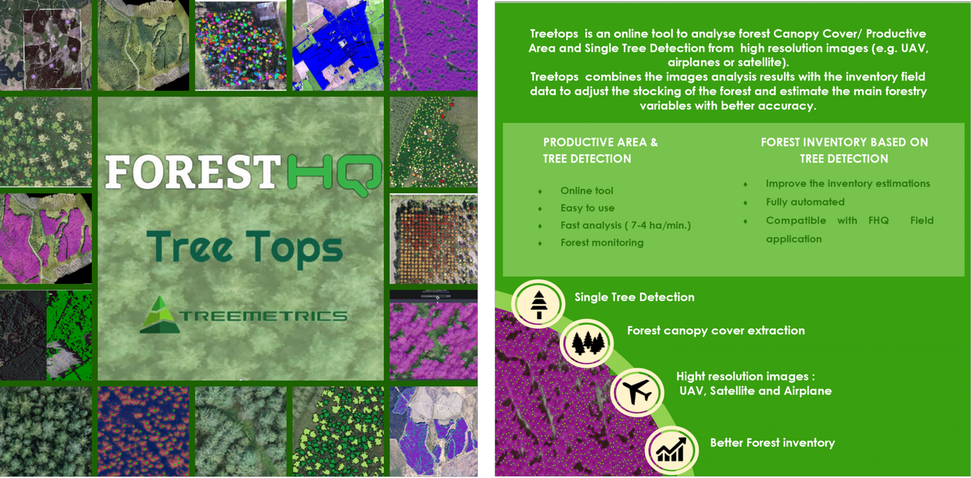
Treetops project has developed a set of easy-to-use online tools to manage information at single tree level for forest operations. High resolution images from Satellites, airplanes and UAV are delivering new levels of image resolution which allows for each tree to be counted. Current traditional manual systems fail to meet the measurement accuracy and efficiencies needed for modern forestry management, especially regarding the tree counting and up-to-date forest canopy areas. Knowing the number of dominant trees in the forest will deliver a new level of accurate information to enable better forest management.
Treetops is a holistic solution that balances the accuracy and efficiency demands of the forestry industry with the needs for cost-effectiveness
Users and their needs
The main stakeholders that can benefit from these new online tools are forest owners and managers, buyers, investors, timber funds and regulatory bodies. Forest owner-managers (i.e. large forest owners that manage their own forests) are the main beneficiaries of this service. Treetops services facilitate the processing of lager forest areas providing automated information regarding the canopy cover and the single tree detection. This new approach recue cost of analytic software and manual digitalisation while provides a better understanding of the true distribution and value of the crop. This service is recommended to have more accurate and streamlined workflows regarding forest monitoring and forest inventory. Forest managers can also benefit from these new services by providing their clients (forest owners) with more accurate and reliable information.
United Kingdom
Service/ system concept
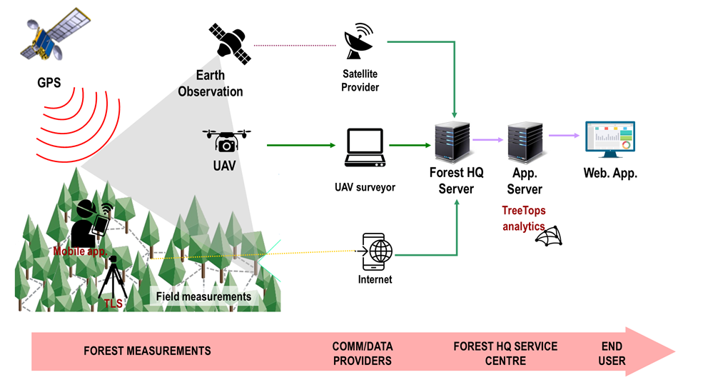
The TreeTops services are integrated in Forest HQ, an end-to-end system developed by Treemetrics. This platform enables the use of different mobile devices to collect field information and provides an application server with tools to analyses Earth observation data at high-level. All the information is stored in a central database and all the information is made available to the user using a web platform.
The main functional components of the system make use of existing Earth Observation data, UAV data, satellite positioning, field devices and cloud services integrated into an end-to-end system directly accessible by forest managers.
The integration of Treetops added new analytic algorithms to automatically analyse Earth Observation and UAV data for forest canopy and single tree detection.
Space Added Value
TreeTops project uses very-high-resolution Satellite Earth Observation (i.e. WorldView-3) to improve the forest inventory assessment and demonstrate the suitability of this type of data for individual tree crown detection.
TreeTops will also use satellite positioning to combine field measurements with Earth Observation by spatially positioning the field measurements collected. GNSS is used by the mobile applications to position accurately each measurement. The satellite positioning is also used by the UAV used in the project.
Current Status
Treetops project has been successfully completed.
Treetops project has met the main objectives, including the demonstration of UAV, Aeroplane and Satellite images for single tree detection and canopy cover/productive area in forest plantations.
The results obtained with the different image resolutions have shown consistency across the different forest stands. The estimation of productive are using the images was able to detect the main gaps in the forest canopy and extract the forest canopy. The tree detection was also successful, improving the result with the image resolution. This range of detection is more precise than traditional stocking plots and area inference where errors grater than 20-30% are common.
These results were used for the combination with field data estimate the stocking, timber volume across forest stands and the main forestry variables with better accuracy.
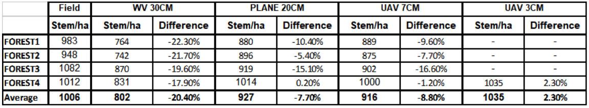
Table1: Tree detection accuracy
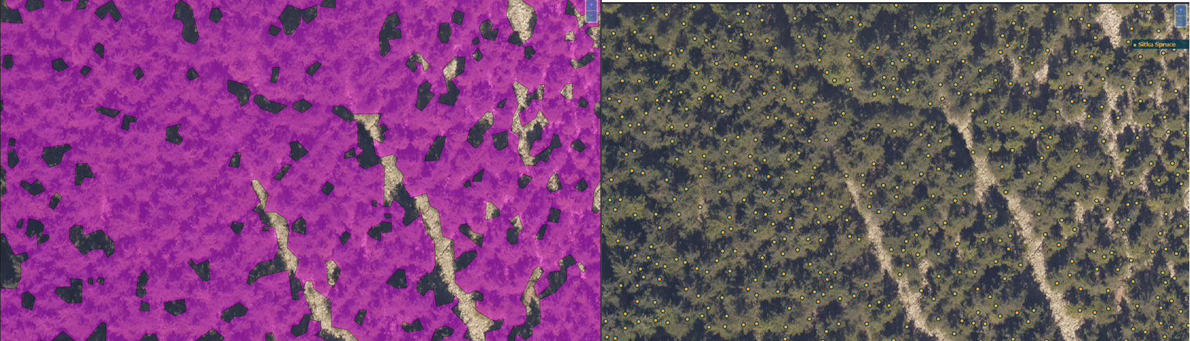
Figure 1: Canopy cover (left) and tree (right) detection using Treetops tools
All the Treetops services are fully integrated in the ForestHQ platform providing the use a better experience in the use of tools and results.
The demonstration with the end user has been successful. During the Pilot the user have carried a practical exercise of using the Treetops services and examine the results. A total of 38 users form different countries have participated in the Pilot providing feedback.
Overall, the user feedback was very positive, the users were especially positive toward the improvements of the inventory using remote sensing data and the accuracy of the images getting the productive area and the single tree detection.
Generally, it can be said that the users in the Pilot have showed that they like the system and the main comments have been regarding the pricing and the possibility to analyse images in other properly and lager areas without need of additional user inputs.
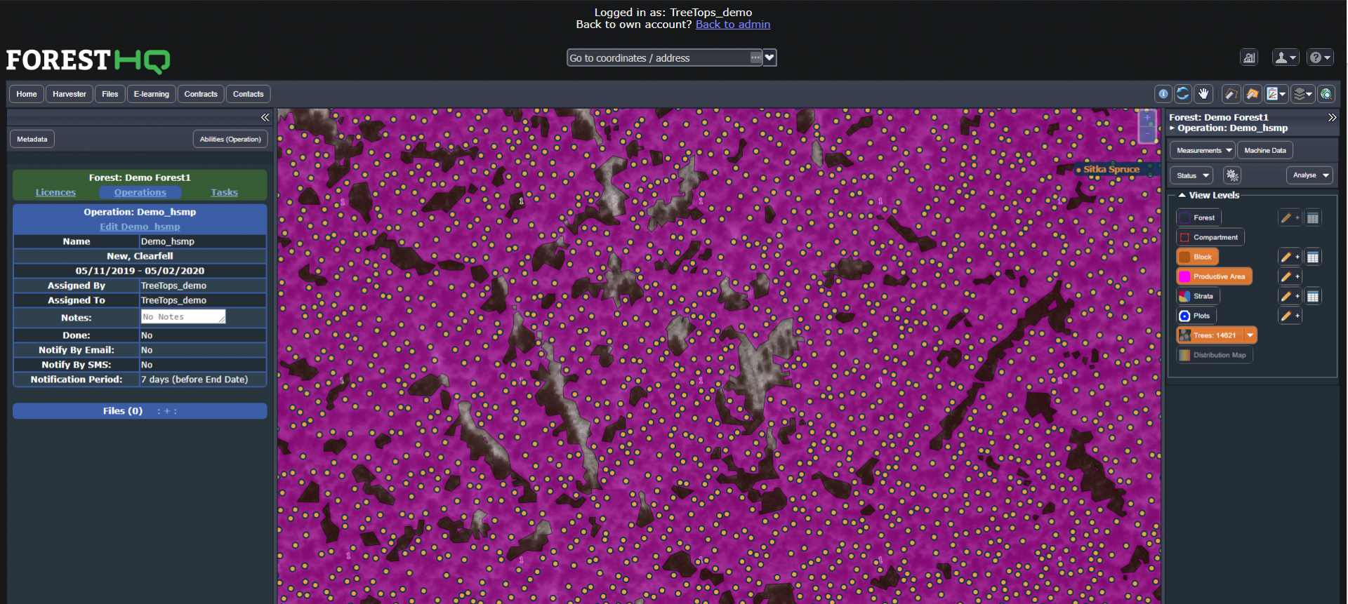
Figure 2: Treetops system