Objectives of the service
The TRIPS Transport Management Tool will support the prevention of road accidents and road safety maintenance, through:
-
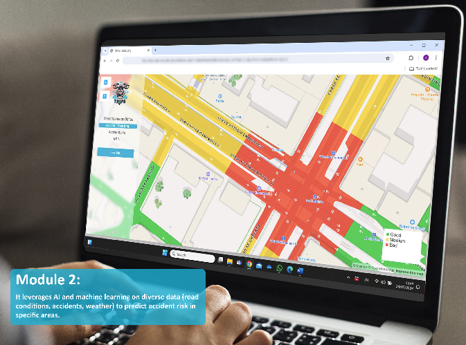
Forecasting of the city areas with the greatest risk of accidents
-
Road infrastructural assessment & Roadway design
-
Safe route planning
-
Emergency vehicle allocation
-
Smart signalling allocation (e.g. in accident-liable areas)
-
Real-time accident assessment & alerting through drone-sentinels
TRIPS tool will be based on
-
User Interface, which will provide advanced analysis and reporting tools
-
The AI-powered Models for accident forecasting
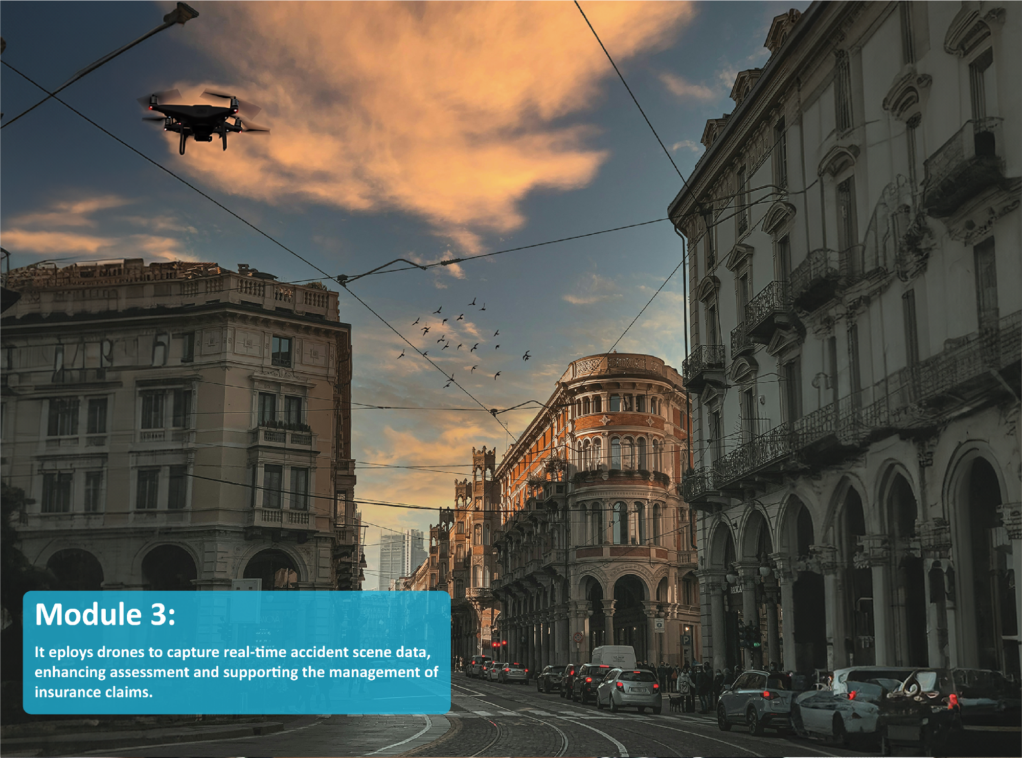
Furthermore, a drone equipped with 5G communication technologies (high streaming, low latency capacity and low battery consumption) could help police departments, first interventions, as well as insurance companies, to provide real-time monitoring severe accident assessment and appraisal. In the future will also provide alarming system with smart-vehicles traveling nearby to warn about ongoing dangerous situations, or to download/upload IoT data with its 5G-enabled communication equipment.
The City of Turin (EU funds and Innovation Department), in strict cooperation with Municipal Police (Technological Investigations Department), will provide the following contribution to the project:
-
Finalisation of User Requirements
-
Access data from dashcams on board of Municipality Police car fleet for road pavement monitoring through;
-
Access to the registry of road accidents in the Municipality (historical data of 5+ years);
-
Provide drones and support the pilot through the Drone Unit
-
Provide the testing area, the “Smart Road Track” in Turin, dedicated to experiment of autonomous driving and connected vehicles in an urban context (https://www.torinocitylab.it/en/experiment-to/smart-road-track).
Users and their needs
The TRIPS Transport Management Tool targets following end – users and their most critical needs:
-
Police departments
Need: dedicated service to reduce accident risks, improve accuracy of technical surveys for road accidents and more quickly, and significantly improve the deployment of vehicles and personnel with respect to the most critical areas.
-
Municipalities
Need: provide to citizens a dedicated service to reduce accident risks, and ensure safety of pedestrians, cyclists, electric kick scooters and others.
-
First interventions bodies
Need: intervene more promptly and with the most suitable technical and medical personnel to save lives
-
Insurance companies
Need: reduce the costs of compensation damages for accidents, and take out more advantageous policies for customers.
-
Public and Private transport businesses
Need: improve the service efficiency to their own customers, and improve personnel safety especially for Food home delivery organisations.
Service/ system concept
TRIPS solution will offer a competitive advantage in reference to others Intelligent Transportation System, in three different areas:
-
Integration of the Earth observation component through VHR satellite images and related computer vision techniques for the assessment of pavement conditions;
-
Severe accident visual assessment through sentinel-drone for support police and insurance companies in carrying out the damage assessment and reconstruct the dynamics of complex accidents;
-
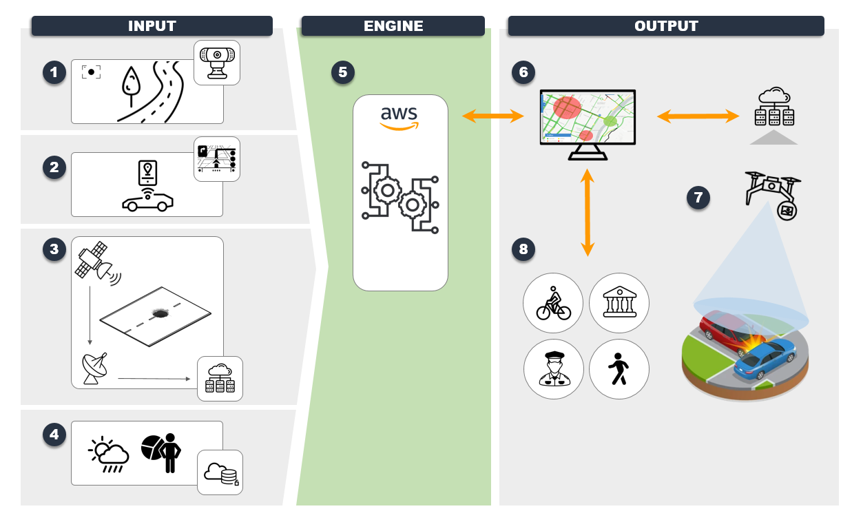
The Data fusion approach with the integration of data from onsite sensors, 5G-enabled drones, satellites (VHR imagery, geo-localization, weather), dash cams and archive data, with related advanced analytical and machine learning techniques, open a wide spectrum of possibilities either in terms of target markets and in developing of cross-competences for future applications.
TRIPS will provide the following web-based services:
-
Risk Assessment Module:
-
Forecast of the city areas with the greatest risk of accidents;
-
Safe route planning
-
-
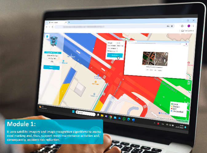
Road Pavement Detection Module:
-
Detection of holes, damage to lanes, and presence of objects on the roadway
-
-
Visual Accident Assessment Module:
-
Analysis of images acquired via Drones using 5G technologies
-
During the Pilot demonstration project the following use cases will be addressed and evaluated by the Municipality of Turin:
-
Use case - Sustainable and Safe Mobility Based on Advanced Traffic Management Systems
-
Value proposition relevance:
-
TRIPS – Risk Assessment Module
-
TRIPS - Road Pavement Detection Module
-
TRIPS - Visual Accident Assessment Module
-
Use case - Advanced Traveler Advisory System
-
Value proposition relevance:
-
TRIPS – Risk Assessment Module
-
TRIPS - Road Pavement Detection Module
-
-
Space Added Value
The following 5G and space assets will be used in the pilot demonstration:
-
Drone real time image acquisition of accident with 5G/satellite geo-location accuracy: The main rationale for exploiting 5G technology in the current use case is to obtain a very precise localization of the drone to enable capturing of detailed visual information on the ground, thus enhancing the image quality of the reference satellite images.
-
The precise localization (in the range of a few centimetres) can be obtained by complementing the GNSS data with 5G localization, creating a wireless ecosystem. Such a wireless ecosystem will therefore be enabled by advanced 5G wireless technologies integrated with existing technologies for the Internet-of-things (IoT) and the global navigation satellite system (GNSS);
-
-
VHR satellite images processed with computer vision techniques could be used to monitor the municipality road infrastructure status (Turin AREA 1 or smaller). The evidence of presence of holes, damage to lanes or the presence of objects on the roadway can highlight dangerous situations due to the non-optimal state of the infrastructure.
-
This kind of monitoring could be performed with a temporal resolution of 2-weeks or monthly and with a space resolution < 5mt.
-
-
Localization data for Traffic index deriving from the use of Geo-localization services.
-
Historic & Forecast weather information, both from satellites, radar and on-site sensors will be retrieved from a weather data provider.
Current Status
The TRIPS project achieved notable qualitative outcomes by integrating cutting-edge technologies to tackle challenges in urban mobility and road safety. It successfully implemented tools to forecast accident-prone areas and assess road infrastructure using advanced Earth Observation data and machine learning techniques. By leveraging 5G-enabled drones, the project enhanced real-time traffic management, enabling precise accident assessments and optimized emergency response strategies. The project demonstrated the effectiveness of combining satellite imagery, IoT sensors, and AI-driven analytics to support informed decision-making and proactive planning. Additionally, TRIPS contributed to the advancement of sustainable urban mobility by reducing accident risks, improving infrastructure management, and fostering collaboration across public and private sectors.