Objectives of the service
Climate change brings many new challenges for forestry operations, especially the proliferation of aggressive species such as bark beetle in commercial spruce forests. Our solution is designed to allow for early detection of stress in forestry operations and supports proper management decisions to reduce and avoid damage.
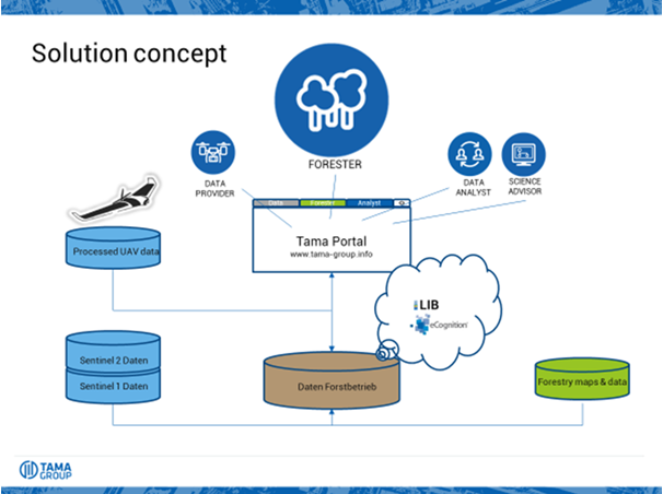
Based on data from Earth Observation satellites (mainly Sentinel-2) and local drone imagery, the analysed data and resulting information will be made available via an online portal to forestry owners and operators who can monitor generic and specific stress in their assets.
The design principles of our service offering rely on standardised, cost-effective drone operations and ubiquitous availability of our online portal.
Users and their needs
The main target of our service offering are small to medium sized forestry operations, managing about 500ha to 2,500ha of forests.
Such forestry operations are typically run by professional foresters. Our user partner, Forstbetrieb von Gravenreuth, is located near Augsburg in Germany, covering about 1,000ha of commercial forest.
Our target users need a faster, better and more cost-effective way to find bark beetle infestations and threats to their forest assets than they have available today. Currently, most of the detection happens in a non-systematic way by terrestrial monitoring (“walk and watch out”).
The initial target user group are forestry operations in Germany, especially in the southern part. The targeted commercial service is also designed to meet needs of foresters in Alpine regions in other countries.
Service/ system concept
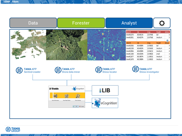
The users obtain access to up-to-date stress maps, including a prioritization in terms of stress degree and scope of the likely problem. The users can then upload GNSS coordinates of the identified stress zones to their field navigation devices to easily find the affected forestry parts quickly. In addition, the users can browse through their assets online, identifying quickly areas of potential change. The system is built on an online portal (hosted by EODC). The analytics core is implemented by remote sensing apps within eCognition.
Space Added Value
Our service offering makes use of two space assets: first of all by intensively deploying Sentinel 2 data, and secondly by making use of GNSS signals for the routing of the drones and the geo-rectification of the images, as well as to guide foresters in the field.
Whilst other offerings either focus on ‘sat only’ or on ‘drone only’ data, our offering brings the two worlds together onto one analytics platform.
Current Status
The study has started on July 2, 2018 and has finished with the Final Review on December 11, 2018.
In the study, User Requirements have been defined in coordination with the involved user representatives.
The System and two Services for forest monitoring have been defined: 1) ’Monitoring’ module based on Sentinel-2 data with resolution of 10 m, 2) ’Monitoring Pro’ module based on UAV imagery with resolution of 10 cm.
A Proof of Concept has been carried out: 6 drone flights were executed from August until October 2018, and bark beetle infestations could be detected and verified. The results were evaluated positively by the involved user representatives.
A Viability Analysis has been carried out and the perspective for service implementation is given. Further effort will need to be invested into the reduction of cost for UAV operations.
The Roadmap for system and service implementation has been defined and continuation with a follow-on activity in 2019 is intended. Target is implementation of an operational service by 2020.