Objectives of the service
The objective of this study was to assess the technical feasibility as well as the economic viability of an integrated service that allows the general public act as witnesses to report various types of incidents which are then disseminated to numerous end users.
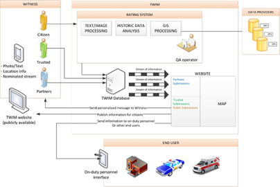
The concept was based on the popular crowdsourcing movement that has caught traction with the population in the last decade, especially regarding emergency reporting (i.e. Haiti, Katrina etc). The feasibility study combined real time location data using GPS to plot submissions on a map to create a live view. The study also tried to establish the usability of a confidence score associated with each of the images - based on various analytical services. These could then be used to filter and rank the submissions.
As well as the technical aspects, the study looks at the appetite of the general public for this type of application, as well as if the end users (i.e. emergency services) can find any use for this type of tool, and how the business plan would be built around that demand for it.
Users and their needs
The direct users of this service are identified as national or regional authorities responsible for the various emergency services that respond to incidents. Specifically this would be the police, fire and ambulance services. Additionally to that environmental agencies are also imagined to be obvious users of this service allowing witnesses to report flooding or earthquake data would allow the Environmental Agency or the British Geological Society do analyses on the data. Indirect users of TWIM may be the more social or financial institutions for instance insurance companies would be interested to see the data about flood or subsidence damage, at the same time media institutions may well want to report on events that have been reported.
Target users who have also acted as the source for various requirements are: SDIS 31(a fire brigade in Toulouse, France), ACPO (Association of Chief Police Officers, UK) and the Haut-commissariat ? la Protection nationale in Luxemburg (HCPN - the Luxemburg Civil Protection Agency).
The British Transport Police has volunteered to be part of our test campaign and have become another target user for the end product.
Service/ system concept
This is the list of services provided by TWIM:
- Collection of messages from witnesses.
- Online map display: geographical representation of the messages.
- Message filtering service: messages are categorised and presented only to the relevant end user based on their preferences.
- Messages rating service, based on message analysis: each message will be subjected through a variety of analysis services (image, text, location...) and given a confidence score.
- Sharing of TWIM messages between different end users.
- Archive message search: useful for investigations or for future prediction services.
- Communication to witness: one-to-one or one-to-many based on location, time, event, etc. This also closes the loop and allows the witness to be informed of the status of their reports.
Space Added Value
Satellite positioning
Knowing where an event is happening is the key of the system. Often, the civil protection agencies receive calls with vague information about the location. The satellite positioning will allow the TWIM Submission to have a location stamp that will allow a more accurate positioning.
Satellite communications
Since TWIM would be useful in emergency situations, satellite communications are essential. The system needs to account for the possibility that terrestrial communications are down or that the event might happen in a remote location where there is no terrestrial coverage.
Current Status
The feasibility study has completed with all the major components implemented and tested, including a verification phase and analysis of outcome.
The implementation of the proof of concept was one of the final areas of development, and this including a bespoke mobile app and a website for the end users where the reports will be shown in the different categories and placed on a map. The messages were successfully processed by a prototype of the filter engine for images and text, with some success. During a test campaign at the British Transport Police the timeliness and accuracy of the system were put to the test, and TWIM performed to expectations in both regards. The lessons learnt and future ideas were amalgamated into the final report document along with the roadmap and viability analysis.
The TWIM feasibility study is completed, and work is being done to research into ways of progressing the initial research into something useful for a paying end user.
For information on the results of the feasibility study, reference is made to the final report. A link to the final report can be found at the foot of this webpage.
Prime Contractor(s)
Subcontractor(s)


