Objectives of the service
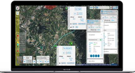
This study aims to identify and analyze the technical and economic feasibility of an Advanced and Specialized Traffic Information Service (A/S-TIS) exploiting space and ground services (SATNAV, SATEO, SATCOM, METEOSAT, 5G) in support of UAM. The study also aims to develop a mock-up for services and solutions demonstration.
Currently, significant progress has already been made toward the definition of UAM operations enabling on-demand, highly automated, passenger or cargo-carrying air transportation services at urban, peri-urban and inter-urban environment, usually in a low altitude airspace.
Now, the most mature UAM applications involve drones for short-range surveillance or package delivery and technological research is now enabling the integration of drones into air traffic composed of other air means and gradually integrate them into the existing urban airspace. UAM could be used for public safety, medical and rescue evacuations, news gathering, traffic assessment, weather monitoring, parcel delivery and similar.
A/S-TIS is one of mandatory services to launch a U-space airspace, and the same traffic data, can provide valuable information to other UAM stakeholders.
The use of space technologies for the development and growth of new aviation and UAM services can bring additional capacities and benefits to European cities and citizens using these services.
Users and their needs
The study plans to involve a large panel of stakeholders (about 20) including:
-
UAS manufacturers and operators: companies involved in the UAS design, manufacturing, assembling and service provision market, functional requirements are collected from a wide range of expected users within UAS manufactures and operators
-
CAA and ANSP: The Italian CAA (ENAC) and ANSP (ENAV) promoting and supporting Urban Air Mobility experimentation and business cases
-
Law Enforcement Agencies: agencies responsible for enforcing laws, maintaining public order and public safety
-
Municipality: Municipality of Bari supporting UAM experimentation in the frame of Bari Smart City programme
-
Technical developers and knowledge leaders: These actors support the development of space solutions
-
Space Service providers: Different technical requirements will be needed by new applications. Space service providers, and other value chain players support the outlining of the technical needs to address
Service/ system concept
The U-space2 project aims to design the architectural role of space services (SATNAV, SATEO, SATCOM, METEOSAT) and develop an Advanced and Specialized Traffic Information Service (A/S-TIS) satisfying EU regulations and providing traffic information to UAM stakeholders (Municipalities, local police, smart city solutions developer).
The following preliminary set of items has been identified as the most relevant for investigation and that could drive the mock-up preparation and technical feasibility
-
Service and system architecture according to collected requirements
-
Space assets: SATNAV, SATEO, SATCOM, AIREON, METEOSAT
-
Terrestrial assets: Communication and data processing infrastructure
Space services complement ground technologies for safe and secure UAM. SATNAV represents the main asset, integrated with ground-based navigation systems, the cascading effect of precision and accuracy of GNSS into A/S-TIS and its impact on situation awareness and safety of the integrated manned/unmanned air traffic is studied. A/S-TIS is provided to end users on geo-referenced maps, including terrain and obstacle models provided by SATEO. Precision of EO maps impacts on UAM corridors design. Lastly, in some UAM scenarios, communication continuity through SATCOM could be critical for safety and security of the service. Other space services are expected to have relevance in the development of UAM (weather forecast and space ADS-B).

Space Added Value
Space and terrestrial assets play a pivotal role in definitions of U-space services for UAM operations and in the development of an Advanced and Specialized Traffic Information Service (A/S-TIS) satisfying EU regulation requirements and providing value added air traffic information to the several UAM stakeholders.
Examples of the benefits that space and terrestrial assets bring are:
-
Space-based ADS-B technologies (i.e., Aireon) for the provision of air traffic information (coverage, data accuracy)
-
Stand-alone and augmented GNSS (e.g., GPS, Galileo, GLONASS, EGNOS) for the provision of high precision positioning, navigation and tracking services of UAVs in urban areas (accuracy, integrity, continuity and availability)
-
SATEO and METEOSAT data into the A/S-TIS in order to enhance the situational awareness of the UAS operator
-
Technical assessment of the communication infrastructure for efficiency of data transmission
-
Mobile data (LTE/4G/5G) communication to improve the network coverage and connectivity
-
Satellite communication (SATCOM) along with ground communication services for homogeneous coverage
Current Status
The feasibility study is now concluded and the Final Review (FR) meeting conducted. A/S-TIS platform, its services and the results of the study have been illustrated with a dedicated workshop to a wide panel of relevant UAM users and stakeholders.
The following activities have been performed during the study:
-
Conducted working sessions with 20 stakeholders across UAM and the satellite industry
-
Identification and selection of most relevant user requirements involving space assets and UAM
-
Definition of the A/S-TIS architecture and identification of the major service and capabilities of the A/S-TIS with a focus on space assets
-
Execution of a cost-benefit analysis and economic viability for A/S-TIS application
-
Outlining of the main roadblocks and recommendation
-
As a result of the study, several end users and stakeholders across the UAM sector have demonstrated their interest in the assessed A/S-TIS and in the participation to future demonstration project (outline proposal has been set up)


