
Objectives of the service
Current solutions available in the market for water quality monitoring are based on water sampling campaigns and/or requires handling of water quality equipment which results in high operational resources and costs. At the same time, traditional solutions are only useful to identify anomalies in the water after they occurred, which normally is too late to take preventive measures to safeguard public health or businesses.
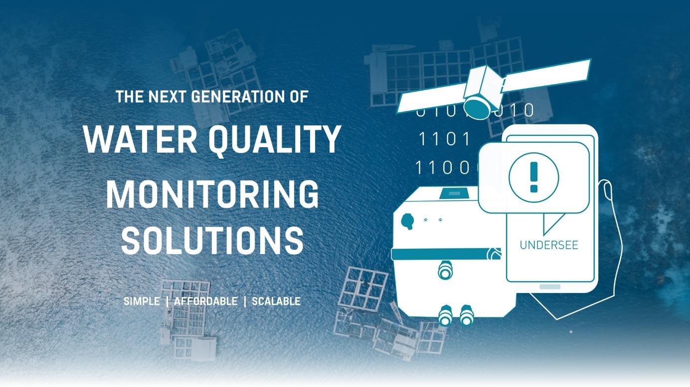
The UNDERSEE new service model for water quality monitoring in marine environments is based on a scalable and easy-to-use decision-making tool, which gives a complete overview about the dynamics and state of the water at different temporal and spatial resolutions.
Users and their needs
The customer segments targeted by our product / service are: (1) Environmental Agencies including research centres; and (2) Coastal and Estuarine Aquaculture Producers including fish-farmers and shellfish producers.
Environmental entities have the legal responsibility to monitor the water quality of marine environments and to maintain the state of the water in good levels. Research centres consume lots of data from water with multiple drives, e.g. validation of their oceanographic models. They require a wide range of water data with low upfront investment in terms of equipment and low maintenance.
Most aquaculture producers are field technicians, they feel more on the instinct and previous learning to take actions on their farms. This segment aims to reduce the operational costs with water quality measurements while being more predictive in terms of water quality for upcoming days, especially for algae bloom events.
Service/ system concept
UNDERSEE provides two water quality monitoring services:
In-situ monitoring service:
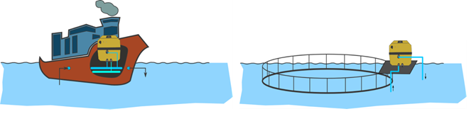
UNDERSEE In-Situ monitoring service includes the installation and maintenance of a small and light ‘FerryBox’ device for real-time water data acquisition. This device is easy adaptable to any existing boat, buoy or aquaculture cage, which includes several sensors to measure a wide range of water quality parameters. The UNDERSEE ‘FerryBox’ is the first Portuguese ‘FerryBox’ system and is like those used in Ships of Opportunity programs, allowing automated measurements of water quality aboard of ships and vessels. This equipment was developed by UNDERSEE and lowers the in-situ data acquisition costs compared to traditional solutions.
The water data parameters included in the standard package are: Temperature, pH, Dissolved Oxygen (DO), Conductivity/Salinity, Turbidity, Chlorophyll-a, Oxidation/Reduction Potential.
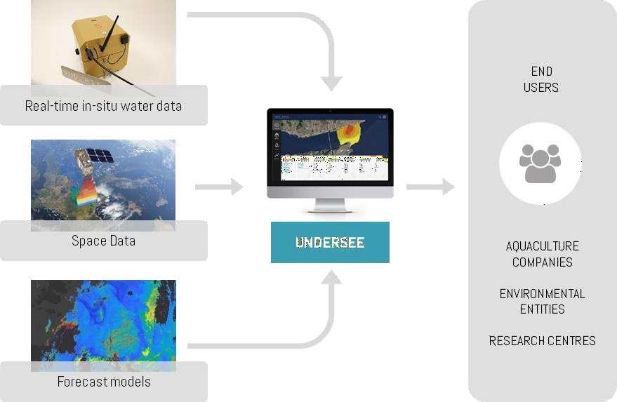
Water quality data collected with the UNDERSEE ‘FerryBox’ is transmitted in real-time to the cloud platform where it is treated and stored. Users have the option to visualize this data in the dashboard and download it in several standard formats including ASCII and netCDF. Historical values, fluctuations, maximum and minimum values are available. Users can set up water data thresholds and receive risk alerts via SMS or email. In this package users have also the chance to validate both satellite data and numerical models against in-situ data.
SeaForecast monitoring service:
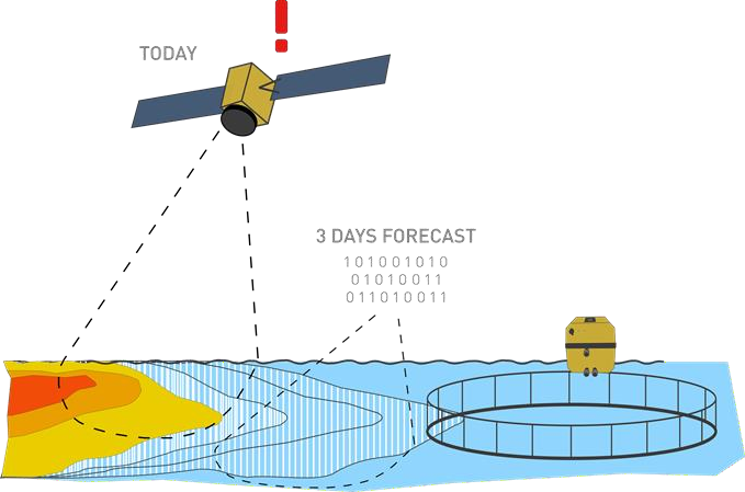
UNDERSEE Aqua Forecast monitoring service includes the holistic overview about the state of the water in estuaries and oceans for today and upcoming days. How? With satellite data and numerical models.
In this package users have access to water data from earth observations (e.g. Temperature and Chlorophyll-a) and water data forecasts for the 3 upcoming days (Temperature, Chlorophyll-a, Dissolved Oxygen, Salinity and pH. Users can set up water data thresholds and receive anticipated alerts via SMS or email including possible e.g. severe oxygen depletion events and algae bloom events
Space Added Value
Copernicus Sentinel-2 and Sentinel-3 datasets are in a daily basis analysed to provide real observations of hydrodynamics and phenomena affecting water quality. In-house state-of-the-art algorithms processing satellite images allow the detection of several parameters including Chlorophyll-a, the main indicator of an algae bloom event.
GNSS system is used to obtain positioning of the UNDERSEE ´Ferrybox´ devices while Satcom may be implemented in situations where the devices are in the outer range of terrestrial communications (e.g. 3G or Wifi).
Space assets are crucial to:
-
Create 2D maps from the water data collected from the UNDERSEE ´Ferrybox´ devices;
-
Provide a holistic overview about the state of water quality in estuaries and oceans;
-
Improve monitoring service reliability due to data combination from different sources. Satellite images combined with in-situ data are sources of numerical models used for calibration and validation. This redundancy avoids downtime periods due to sky visibility and sensor’s decalibration;
-
Create early warnings of water quality changes including algae blooms events;
Current Status
The UNDERSEE demonstration project has started in June 2020. Pilot Demonstration sessions with the end-users have been completed in July 2022.
The following important achievements have been reached:
-
Installation and testing of an in-situ, water data acquisition system with:
-
Water data values deviation to traditional monitoring lower than 16%;
-
Alarms to low oxygen levels with precision and accuracy over 80%;
-
System communication with 95% uptime.
-
-
Anticipation in 3 days the occurrence of an algae bloom;
-
Anticipation of the potential presence of a toxin in the water;
-
Reduction in 14% the expenses with water quality measurement & sensors maintenance;
-
Reduction in 3% the costs with fish feeding due to water forecasts;
-
Reduction of stock losses up to 270k€/year when safeguarding the production of unexpected events.