Objectives of the service
The objective of the services is to provide a uniform measurement of urban area evolution of cities from all around the world. In fact, our product Urban Space Series enables to measure the evolution of the shape and the size of urban areas from satellite images.
Therefore, it will enable our clients to have access to standardized analytics across the world and comparable between countries.
Besides It allows to measure the economic growth of a region or a country, the platform aims at being applied to one of the main subjects of urban studies: the relationship between city growth, economic development and climate change, and in particular the role of the city topology on carbon emissions.
For the development and implementation of the solution Urban Space Series, it has been necessary to develop a robust algorithm capable of analysing the huge amount of data within the satellite images. The algorithm is currently able to deal with different city topologies, densities and construction types. Indeed, cities have different infrastructures across continents, fields can also be very different depending on the region and season: all those different characteristics of cities need be learned in the training set.
Users and their needs
The solution will provide our clients with a unique methodology in order to compare easily the different cities’ features. It is a real time solution as it provides a features’ measurement in advance compared to official data and not at a unique date but at different times. It is also an automatic solution as by giving in input only the city name it directly gives the features in output with less than 5% of error.
The solution will deliver recurrent revenue with SaaS platform with a large scope of clients among sovereign wealth funds, central banks, macro investment firms, large asset managers or strategic department of corporate groups who are interested in the knowledge of the urban development and therefore by getting a uniform measurement of urban area evolution of cities from all around the world.
Service/ system concept
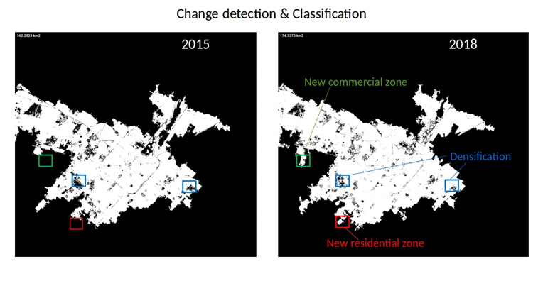
When the service is deployed, the user will have access to the shape of a city at a given date, but also to the evolution of the shape between two different dates and to the size of the urban area from satellite images.
The user will provide a city’s name, then our system will get the satellite data from the Sentinel-2 API, create the different indices by combining some raw bands to better recognize and learn some major land features, and do the prediction with the CNN model before extracting the shape and the area of the selected city.
QuantCube provides to its clients a dedicated API to access in a timely fashion current and historical values of Smart Data and sets up a web portal for online visualization of the latest values of Smart Data developed by the company. This Urban Space Series will be part of the global Smart Data product of the company.
Space Added Value
Data on urban development are difficult to analyse in a global manner. Each country has its own methodology to measure urban development, also data refresh frequency are proper to each city. The creation of a uniform measurement of urban area evolution of cities from all around the world has a high potential value. For this purpose, we have developed our methodology based on Sentinel-2 pictures: the product Urban Space Series enables to measure the evolution of the shape and the size of urban areas from satellite images.
Current Status
Currently, Urban Space Series offers the shape and the area of any city, with a frequency update of some weeks. Changes detection includes now a rough semantic classification.