
Objectives of the service
The uSmart Revenue project developed uREVEAL, a new AI module and SaaS service that utilises AI and Machine Learning to automatically detect missing or under-assessed rateable properties by integrating open datasets (including Companies House, Ordnance Survey and Open Street Maps) with closed datasets (Local Authority Non-Domestic Rates valuation roll data) and Earth Observation data, satellite imagery and mobile GPS data. The CCN extension expanded coverage to domestic as well as non-domestic properties, improved detection accuracy through AI upscaling techniques, and integrated GPS mobile application data to validate property occupancy. The service is deployed and operational at https://usmart.io/org/ureveal/
Users and their needs
The cost of fraud to UK local government is estimated at £2.6 billion annually, with approximately £2.2 billion attributable to missing or under-assessed non-domestic rateable properties. uREVEAL addresses this by generating up to £400,000 a year in identified missing revenue for each Local Authority across England and Wales. This is money that Local Authorities can use to fund services and make communities better places to live.
uREVEAL serves three primary user groups: Rates and Revenue Research Teams at Inform CPI (Analyse Local), who use the platform to prioritise their detection workload; Rates and Revenue Case Teams, who use the evidence-rich data cards to build cases for VOA submission; and Local Authority Revenue Teams, who quality-assure outputs before submission. The platform was piloted across six Local Authorities achieving good general usability scores and confirmed building detections.
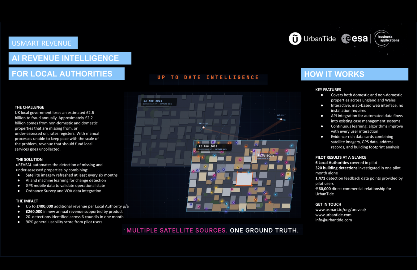
Service/ system concept
uREVEAL automatically identifies buildings and addresses that are missing from or under-assessed on the Non-Domestic Rates and Council Tax registers by correlating multiple data streams through AI and machine learning algorithms.
The following overview covers how the system works.
uREVEAL is a cloud-based software-as-a-service (SaaS) solution accessed via a secure web interface. Local Authority non-domestic rates valuation roll data is uploaded into uREVEAL, and the system handles the rest: data is geographically linked with a spatial location on a map; satellite imagery from that area is assessed; buildings are detected using AI algorithms and linked with the valuation roll data; two images with different time stamps are compared to highlight differences in building outlines and other rateable elements; the floor area of premises is used to evaluate any potential increased floor area; mobile GPS application data is used to help determine if buildings are in operational use; and imagery and public sector data is linked with OS mapping and presented in the uREVEAL interface. Results are provided via API integration into existing rates management systems, an interactive map-based interface, raw dataset exports, or concise localised reports.

Space Added Value
uREVEAL is built utilising 3.0m and 0.50m resolution satellite imagery from market-leading providers including Planet and GeoCento, who are tasked to capture new imagery over areas as required. The AI processing enables assessments to be undertaken at scale and significantly faster than manual approaches. GPS mobile application data provides an independent layer of validation, confirming building occupancy and use independently of satellite change detection. The combination of multi-temporal satellite imagery with address register data and GPS activity data represents a uniquely integrated application of space assets for public sector revenue recovery.
Current Status
The uSmart Revenue CCN extension was completed in May 2026. The uREVEAL service is operational and has been piloted across six Local Authorities. The majority of primary pilot KPIs were met or exceeded. We have a live commercial agreement in place.

Prime Contractor(s)