
Objectives of the service
Water resilience assessments are typically conducted either at a national level or within small test regions. resulting in fragmented monitoring maps categorised by different parameters. This approach results in a plethora of maps and statistics that, while theoretically informative, are difficult to understand due to their fragmented nature, especially for non-scientists.
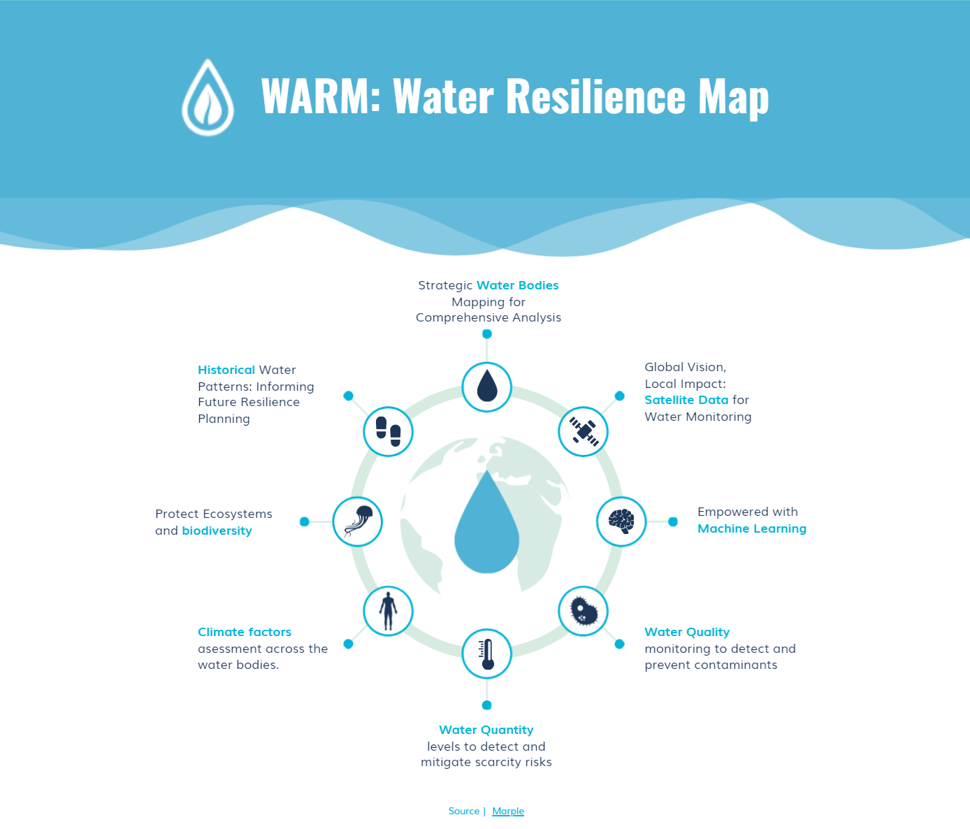
To address this, Marple developed a unique approach that integrates water quantity, quality, and climate factors using satellite data, EO scripts and machine learning. WARM is supposed to be a single digital map that comprehensively visualises the overall level of water stress.
Using Sentinel satellite data with global coverage, multi-temporal capabilities, and a high resolution capability of 10 metres, WARM provides an enhanced level of granularity that can be flexibly scaled to monitor areas across various scales.
Users and their needs
WARM targets several customer segments, in particular Climate Monitoring Organisations, Development Aid Organisations, Private Companies and Governmental Organisations.
Marple worked with ADRA, Dalberg Research in Kenya and other parties to gather ground truth data about water quantity, quality, and climate factors in order to develop satellite data based algorithms for monitoring so that potential customers can set targets within their projects and activities which can be measured with a baseline. Additionally, potential customers are able to monitor change over time. Besides Kenya, Marple analysed the priority basin of the Guadalquivir River in Andalucía.
The concrete user needs are to
-
identify water stress in localised areas.
-
assess situations in specific regions regarding water quantity, water quality and climate factors.
-
monitor changes and measure improvements or deteriorations.
-
visualise the status and changes in a simple, elegant way.
Service/ system concept
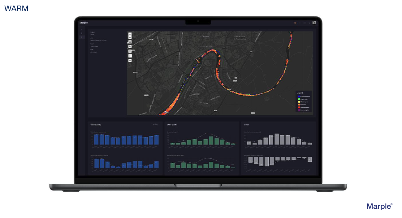
WARM provides the user with an interactive web-based map showing water stress resilience based on three criteria:
-
Water quantity
-
Water quality
-
Climate factors
Users are able to look at a region and assess general conditions, enabling detailed analysis of specific parts in a higher detail to comprehend the current situation as well as historical patterns in order to plan their projects based on reliable information.
Space Added Value
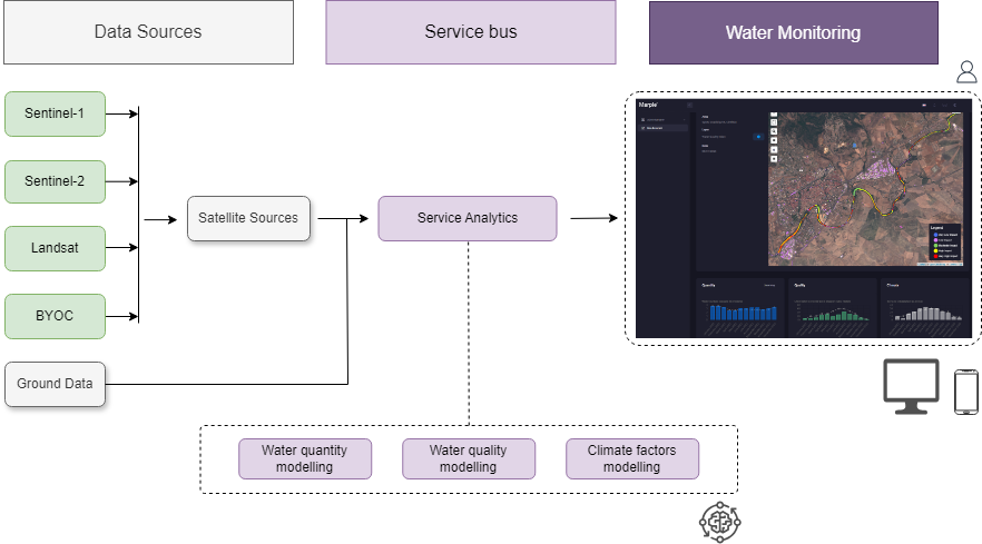
WARM uses satellite data from Sentinel-1 (SAR), Sentinel-2 and Landsat 8 (optical), and EnMAP (hyperspectral). Water surface area and spatio-temporal changes are calculated from Sentinel-1 data, whereas water quality is inferred from optical and hyperspectral data. Ground data includes environmental open data, authoritative agencies datasets and sensor data from control networks where available. Water indexes, such as MNDWI (Modified Normalised Difference Water Index) and colour indexes, are included in the data analysis.
The use of satellite data provided by Copernicus Services allows monitoring large areas continuously and accurately, reducing the need for extensive ground control networks.
The added value is a result of insights gained by combining satellite data with existing ground data, followed by the application of machine learning algorithms to identify patterns. These patterns open up new ways of understanding past, present and predicting future developments.
Current Status
Marple completed a mockup of WARM based on conducted interviews with more than ten organisations interested in a water resilience map for measuring the impact of water-related activities. WARM has been presented to the CEO Water Mandate and its member companies on several occasions and it is discussed with some of the member companies to match their specific needs with WARM's capabilities.
The technical feasibility has been confirmed and various satellites, bands and indices have been incorporated into the data analysis activities in order to design the product features and produce overviews of key findings for each basin.
The feasibility study was successfully completed in June 2024 and it is planned to launch a demonstration project as a follow-up activity in late 2024 in order to develop a prototype of WARM as preparation for market entry.
Prime Contractor(s)
