Objectives of the service
The objective of this service is to improve monitoring of changes in water resources of individual lakes and reservoirs to support optimised hydropower production planning, improve price predictions and market analysis.

Users and their needs
In order to operate the hydropower system in an effective and environmentally-friendly way, the sector needs to utilize new opportunities for obtaining better data input on available water resources to improve their operations and to meet requirements from the society.
Today, existing solutions in the market provide data on available water resources on aggregated level for a region. This leads to inaccuracies in modelling estimations and production planning, leading to loss in income and in-efficiencies on use of water for power production.
For market analyst and traders reservoir filling level information is known by everyone and doesn´t give an edge in understanding market developments.
With additional information on water volume and energy filling levels of individual hydro power reservoirs production planners and energy traders can maximize profits and market analysts can further strengthen their understanding of market movements.
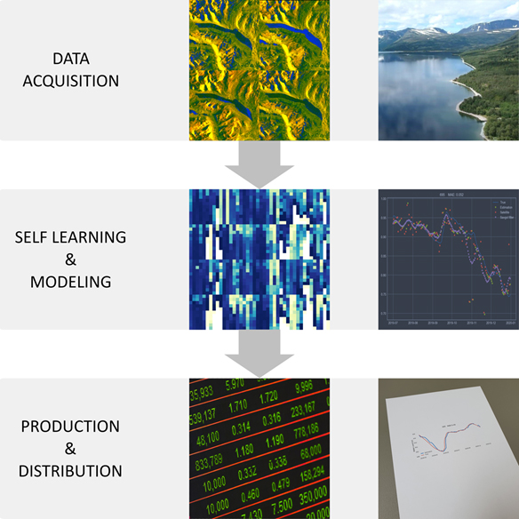
Service/ system concept
The Concept of the service is to provide continuous updates of information to hydropower production planners, commodity energy analysts and traders.
Following products for individual hydropower reservoirs will be delivered with this service at least on a weekly basis;
- Filling levels (%)
- Water volume (m3)
- Water level (m)
- Energy potential (GWh)
With these products users will have access to information which is today not available in the market enabling them to maximize profits, optimize hydropower production scheduling and further improving market analysis.
The underlying concept is to track changes of water surfaces on hydropower reservoirs utilizing Earth Observation data. Radar images from Sentinel 1a/b and Sentinel-2a/b images are utilized for this product.
Space Added Value
Space assets used in this demonstration project are radar images from Earth Observation Satellites Sentinel 1a/b. For the WaterInfo Extension we have also developed capabilities to manage measurements from the Sentinel-2a/b satellites. Also methodology was developed to generate reference data using Earth Observation measurements in combination with Digital Elevation Models (DEM) and other information.
Current Status
The project is currently producing data and water products for 40 hydropower reservoirs in Norway and 3 reservoirs in South East Europe. The systems is operational and generating new data on a weekly basis.
The products are currently being demonstrated to potential clients in the Nordics as well as in Europe.
The Final Review of the WaterInfo Demonstration Project was successfully held 24 April 2020 followed by a Final Review of the WaterInfo Extension 7 July 2021. By end of 2021 all major reservoirs in continetal Europe will be monitored.