Objectives of the service
Our service provides a continuously updated data stream about the environmental health of inland water bodies. The service is an API that provides monitoring and reporting capabilities that allow private sector and public agencies to track a set of specialised and highly descriptive Water Health Indicators. Indicators will be physical descriptions derived from satellite remote sensing, such as water extent, turbidity, chlorophyll concentration, and evapotranspiration. One key advantage of EO-derived indicators is that they are harmonised in time and space. They are computed with the same underlying method and based on the same input data, regardless of the observation date or geographic location. Sources like the Harmonized Landsat Sentinel-2 (HLS) dataset help make the indicators consistent without the usual overhead of massive data processing. This property makes the indicators compatible and comparable against each other without the usual overhead of massive data processing.
Users and their needs
Despite the clear benefits of space technology, many organisations, including environmental protection agencies and consulting firms, face difficulties in effectively using Earth Observation data on a large scale. An example is the Water Resilience Coalition, a group of private sector companies that signed a pledge to improve the resilience of water basins around the world to climate and human-induced stress, aiming to enable wider technology adoption. Challenges to overcome include a lack of harmonised baseline data, the limited scope of existing datasets, and the dispersed availability of datasets.
The critical pain point for EO-based water monitoring is to rapidly convert EO sensor data into data that describes a physical characteristic on Earth. This is difficult to manage and harmonise and it is challenging to scale such massive data architecture. The few organisations that have the in-house capacity to do this work are duplicating the same “undifferentiated heavy lifting” of converting this data to a set of industry-standard approaches.
We partnered with EDP Labelec - center of technical excellence, as a test user of the WHIS system. Labelec is a research laboratory integrated in EDP, a global energy company with roots in Portugal. The Labelec laboratory has decades of experience in water quality monitoring. For WHIS, Labelec provided crucial input about how our system can be used in practice by specifying their requirements and sharing in-situ data that can be used for indicator validation. Labelec has identified EO data as a valuable source of water quality information that is complementary to their in situ measurements. The WHIS system has the potential to help them simplify and expand their water monitoring programs.
Service/ system concept
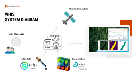
Our system consists of four different layers
-
Indicator pipeline
-
Indicator API
-
Monitoring service
-
Application layer
The production of the Water Health Indicators requires automating the execution and calibration of scientific algorithms, an area we have deep technical experience. We partnered with academic institutions to identify suitable algorithms we can adopt in the product.
The main delivery mechanism for indicators is an industry-standard API that makes it easy for organisations to integrate Water Health Indicators into their own analysis and decision-making workflows. We provide a SpatioTemporal Asset Catalog (STAC), which follows an open standard for describing temporal and spatial data and allows for spatial and temporal searches and directly loading relevant data in Analysis-Ready and Cloud-Optimised (ARCO) formats.
To service users without data science capacity but need notifications of specific events, we have explored the need for a monitoring service that allows users to subscribe and be alerted when a meaningful event or change occurs.
Space Added Value
For integrating Water Health Indicators into their existing decision-making, some organisations will need a customised application layer. This could be anything as simple as an application that provides tabular data and time-series charts for a particular water basin, to more complex ones that allow for multi-criteria decision-making to plan a remediation effort.
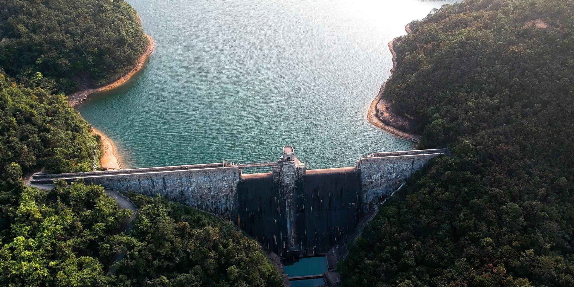
Space technology, and Earth Observation (EO) in particular, has enormous potential to assist in monitoring water resources and updating water management models. EO data can unlock new insights into where ecosystems are most affected, help in designing more effective remediation strategies, and monitor and adapt these interventions. In this study, we focused on Sentinel-2 data to consistently monitor water quality for many inland water bodies, which is hard to achieve with in-situ methods.
Many organisations that do not have in-house capacity are at the whim of external organisations that may not produce this EO-based data with the regularity or speed necessary, and may produce snapshots at different scales and timeframes, making it hard to collect these into an overall picture of the current state of water resources. Space-based water health indicators will bridge that gap and reduce costs.
Current Status
The WHIS project has been completed successfully. Over the course of this project, we have built a water quality monitoring system from the ground up. In collaboration with our partner Labelec we have identified 13 water bodies in Portugal that have served as study areas for the WHIS System throughout our feasibility study. The scientific assessment from MARE Center has made it clear that custom atmospheric processing is important for obtaining the best possible results. We have therefore built a backend processing system that can process all of the Sentinel-2 archive for each lake, comparing multiple atmospheric correction algorithms. The resulting data archive is managed using eoAPI, a full Earth Observation stack that makes our data discoverable and interoperable. Data is registered as Cloud Optimized Geotiffs (COGs) in a custom STAC Catalog and exposed to users through OGC compliant API.
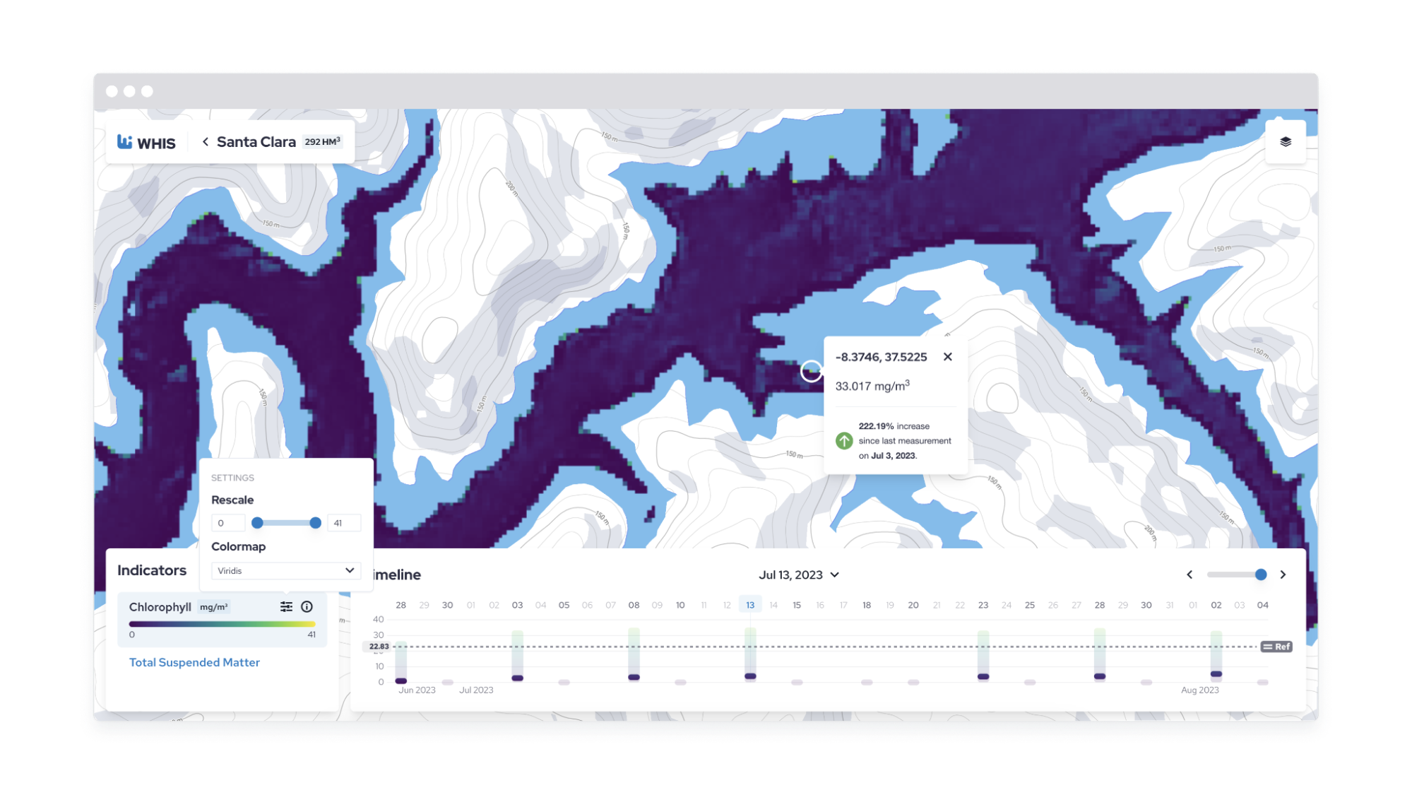
We have also developed an interactive frontend interface that allows users to explore the datasets we created. The interface lets the user select a lake from an overview, and then explore data from different dates. Values are displayed on a graph and the data is shown on a map as well. The screenshot above shows the exploration part of the interface.
We are grateful for all the support provided by ESA throughout the development of this feasibility study and thank our project partners who helped to make WHIS a reality.
Prime Contractor(s)