Objectives of the service
The key product/service is to provide a monitoring of damages to agricultural and environmental areas caused by wild boar (Sus scrofa) using remote sensing data. The technical key idea is to upscale from the investigation of local areas via high resolution aerial images to larger areas via satellite data.
The benefits of such an innovative monitoring scheme can be manifold for a wide variety of stakeholders, the main asset being the first-time delivery of large scale objective data on this matter which can be used e.g.
- as a common ground for discussions between opposing parties (farmers, forest owners, etc.) regarding questions of accountability for considerable economic damages,
- for the development of a suitable wildlife management or effective hunting regimen, e.g. in national parks or highly cultivated areas (national park authorities, hunting communities, land owners, etc.),
- to protect animals put at risk by wild boar, like ground nesting birds, and the habitat itself (Oja 2017)
- and potentially as a supportive measure in the prevention of economically disastrous outbreaks of epidemics like the African Swine Fever (ASF) in livestock (meat production industry, health authorities; see Halasa et al. 2016)
Users and their needs
- Farmers: the following information is needed: Are crop fields affected by damage (qualitative information: yes or no)? Furthermore, a quantitative evaluation (area and percentage of damage?) should be included. If applicable, the potential economic losses can be estimated.
- Traffic authorities and insurance companies: The following information is needed: Where are hotspots of wildlife activity (i.e. potential road crossings) located? Can changes of hotspots be detected promptly?
- Hunters: they can profit from an objectification of crop damage monitoring. Furthermore, depicting hotspots of wildlife activity can help in increasing hunting efficiency.
- Nature conservationists: Aerial monitoring of protected areas (e.g. nutrient-poor grassland, an important breeding habitat for ground-nesting birds) can help in improving protection measures, e.g. regulating the use by livestock or wildlife.
In a potential Demonstration Project we would start with the German and European (e.g. Luxemburg) Market. An expansion to the worldwide market is possible based on satellite data and external high resolution aerial data in combination with our interactive webpage.
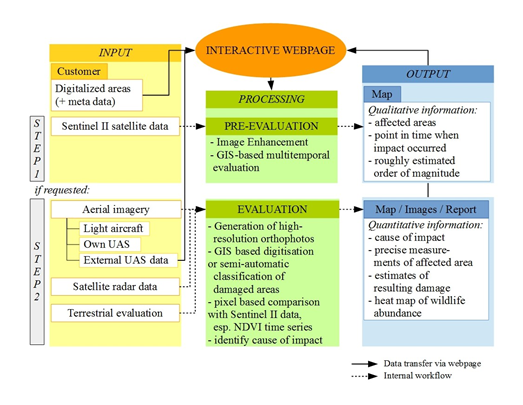
Service/ system concept
The workflow could be the following:
- A customer uploads for example a GIS shape file with the areas of interest and places the order.
- The webpage is being used to gather information, to stay in contact and to present data in a direct way.
- We propose a study design. A standard product could be the monitoring by satellite data for e.g. five years. It could also be a combination of satellite data and high resolution aerial images. If the standard satellite assessment reaches a predefined threshold (e.g. number of affected fields), a flight campaign could be started.
- The monitoring or the assessment is being done. This is done mainly manually at first, later the use of automatic or semi-automatic algorithms could be implemented.
- The data are being presented on the webpage. Possible end products could be: areas of interest are affected by wildlife (yes or no), quantification (number of square metres), map of abundance (heat map), identification of road crossings, etc.
- The customer can download products from the webpage.
Space Added Value
We would like to offer two main products:
- Monitoring with free Satellite data (e.g. Sentinel-2 data): here we do address a mass market, with mainly human resources as input.
- Monitoring with high resolution data (satellite, e.g. TerraSAR-X, manned aircraft, UAS): these are more sophisticated products, with higher costs to produce them. At first, we address a specialized market, which also could develop into a mass market (external UAS data combined with our know-how and platform).
Our approach represents a standardized and reproducible monitoring and documentation of damages. Furthermore, it offers advantages for monitoring large areas (e.g. large crop fields) and represents a solution that is independent of single stakeholders and at the same time can bring all stakeholders together on one platform. Moreover, the digital assessment of damages caused by wildlife is less time consuming, whereby the users can save valuable labour power.
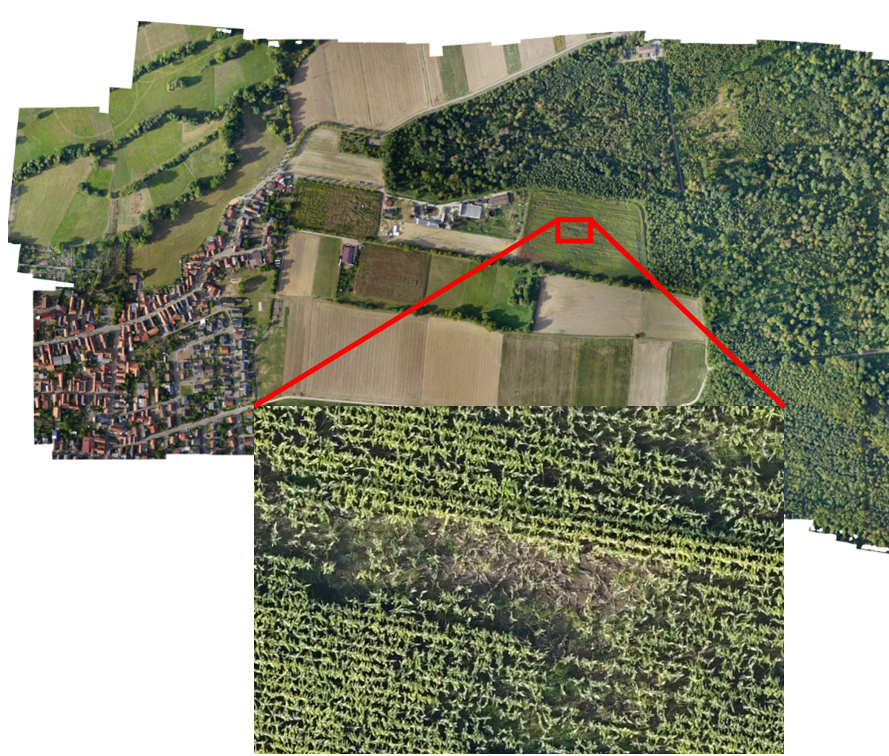
Example: Orthofoto and Zoom-in of maize fields with damages
Current Status
Within the project it could be shown, that damages in agricultural and environmental land can partly be documented even with relatively low resolution satellite images. For a quantitative documentation and to reliably assess the reason for the damage, other data like high resolution aerial data out of flight campaigns (UAS or manned) is needed.
The project is being completed as a feasibility study (final report in December 2018).