

Objectives of the service
The Water industry within the UK faces a number of challenges due to the scale and remoteness of its assets. These distributed assets require increasingly intuitive methods for ongoing monitoring due to budget reductions and increasingly volatile weather caused by climate change. Satellite applications are yet to be widely adopted within the water sector which provides a huge opportunity for the consortium to work with industry to deliver a truly disruptive and useful service offering. Earth observation techniques have shown themselves to provide solutions to some of those challenges particularly in flood mapping and terrain deformation measurement. GNSS technologies have also shown themselves to provide great value in measuring the movement of earthworks and structures over time to give engineers a greater understanding of their assets’ health.
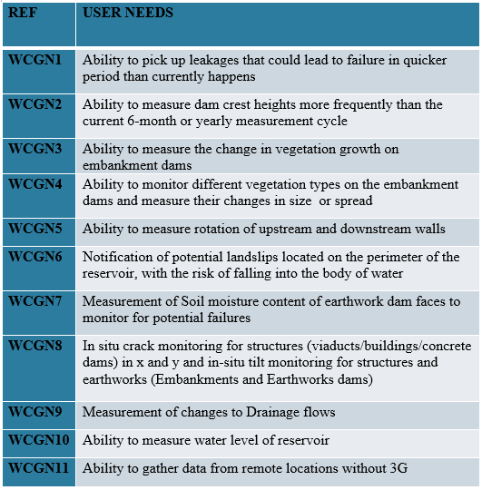
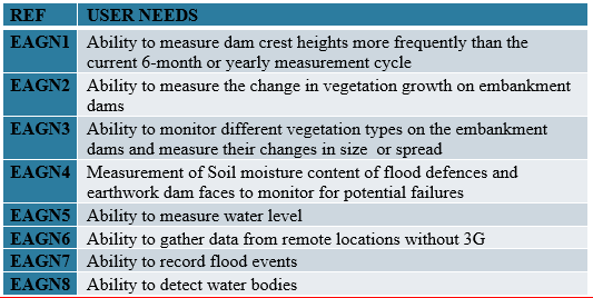
Users and their needs
The user group was largely focused on reservoir management although a number of the attendees to the user workshops had a much broader remit covering all innovation across their respective companies. Their user needs were captured in the following table:
The Environment Agency’s user needs are shown in the table below:
Users are all based in the UK.
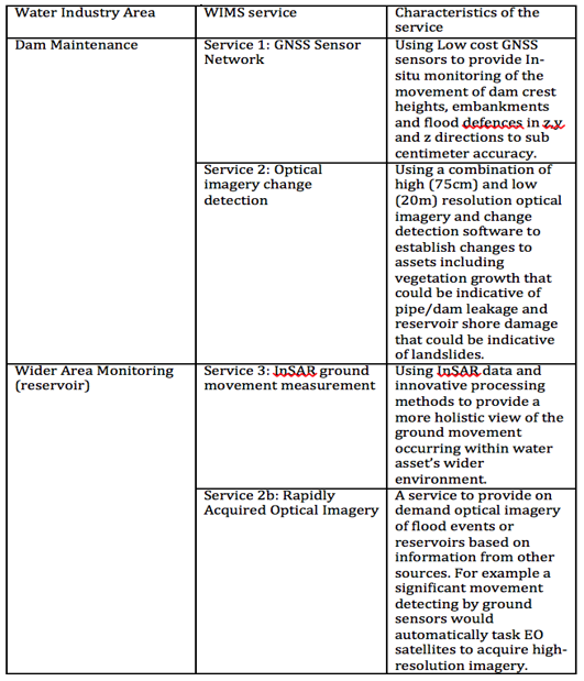
Service/ system concept
The users will receive a variety of condition and measurement data from a number of satellite applciations and services. The below table explains this further:
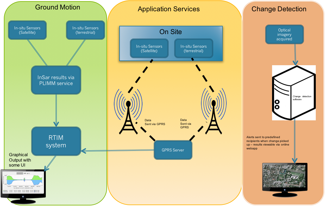
The building blocks of the service can be seen in the following diagram:
Space Added Value
Satellite navigation and Earth observation are the two pace assets that will be utilised during the delivery of the service. The low cost GNSS sensors developed by Nottingham Scientific LTD in conjunction with Moniteye will be able to provide X,Y and Z movement of dam crests and embankments to mm accuracies. This measurement is currently only derived using geodetic levelling techniques on a 6 monthly or yearly basis. In-situ GNSS sensors would provide movement data on a daily of even hourly basis allowing a much better understanding of a users’ assets. InSAR Output developed during the PLIMM project will also be used to provide wide area ground movement data giving user a scale of data previously not accessible through terrestrial methods. Finally, combining optical imagery and change detection algotrithms will enable users to be alerted to changes in the environment surrounding their assets. For example the system would be charged with picking up changes in vegetation growth that may be indicative of a leak in the dam wall.
Current Status
The consortium was able to successfully bring together a wide range of companies within the sector enabling a strong set of user requirements to be developed. This highlighted both the similarities and differences between those isolated during the TIMS project and those that uniquely affect companies within the water sector. Confirming these similarities was also vital to proving the multi user concept of the PLIMM service. The consortium has achieved great buy-in from the industry and a number of the user group will be involved in the PLIMM demonstration project (Environment Agency and Thames Water). Other user group members (United Utilties) have also indicated that they would be happy to commit to a future water-themed spinout project from the PLIMM project.
Prime Contractor(s)

Subcontractor(s)
