
DEADLINE SUBMISSION OF OUTLINE PROPOSAL: 14/03/2023
DEADLINE FULL PROPOSAL SUBMISSION: 30/05/2023 (DATE IS TENTATIVE)
THE OPPORTUNITY
The thematic call “Satellite Connectivity for Autonomous land vehicles safety” aims to foster the development and showcase of innovative applications for the safe and secure deployment and management of autonomous and connected land vehicles by integrating satellite communications and other space assets with terrestrial and digital technologies.
With massive bandwidth requirements due to highly sophisticated software systems, the Connected Cars connectivity market represents a huge addressable market, expected to reach USD 1 billion in 2029, requiring a global network leveraging both satellite and terrestrial technologies to connect cars everywhere.
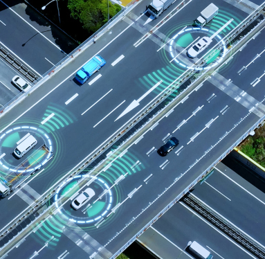
Satellite communications is extremely important to ensure that connectivity is ubiquitously available, even in remote and rural areas, or in case of a failure, thereby maintaining safety functionality and paving the way for faster deployment of future connected and autonomous vehicles and guaranteeing that mobility services such V2X (Vehicle-to-Infrastructure) connectivity are available. The combination of terrestrial and satellite communication networks is making possible intelligent and ubiquitous V2X systems with significantly enhanced reliability and security, hyper-fast wireless access, as well as much seamless communication coverage.
In addition to the cars, Connected Autonomous Vehicles (CAVs) address several other types of land vehicles. An autonomous truck, similarly, is equipped with technology that allows it to communicate with other vehicles and road infrastructure, assess traffic situations and make right driving decisions. Other examples are the autonomous shuttles that are located around convenient public infrastructure hubs, such as business campus, airports, train stations, bus stations, shopping centres and large public or commercial buildings and parks. Fundamental for the safety of the autonomous vehicles is the provision of seamless connectivity that can be achieved by the convergence of satellite communications and terrestrial networks.
Key Focus Areas
The objective of this thematic call is to demonstrate the key benefits that satellite connectivity can bring to support the autonomous land vehicles sector. The thematic call purposely addresses a wide spectrum of applications including but not limited to the use cases below.
- Connected car performance parameters collection and processing. Automotive industries need reliable, consistent communications capabilities; therefore, they need to adopt satellite communication systems to complement terrestrial networks in a situation of emergency.
- Seamless transition between 4G/5G and satellite communication. Vehicles are expected to leverage hybrid connectivity (cellular and satellite) and automatically switch to the most convenient network by ensuring coverage in every situation to provide ubiquitous connectivity.
- Commercial Fleet management and logistics. Commercial fleets are increasingly relying on uninterrupted connectivity for fleet management and logistics purposes. Digitalisation of the fleet is usually relying on available telecommunication technologies such as 4G; however, in some cases like long-haul, a fleet manager may find satellite communication an appealing solution to monitor the health and condition of its assets.
- IoT for connected devices on field monitoring and connected vehicles. The increasing availability of sensors and actuators of smaller dimensions and lower power consumption has driven the adoption of Internet of Thing technology across a wide range of sectors including autonomous vehicles. In this context, connected devices can be adopted to monitor, alert, and respond. IoT technology is empowering the “connected operations” throughout vehicles telematics and smart monitoring sensors (e.g. narrowband sensors, security cameras, etc.).
- Real-time hazard warning. This use case relates to an autonomous vehicle receiving information relevant for the road/route ahead that require to increase driver awareness or reduce reliance on automated vehicle features like lane keeping. The information could be related to a hazardous location real ahead, a route obstruction, potholes, or others.
- Hazard information collection and sharing. Vehicles can collect hazard and road event based on vehicle sensor data for further use by autonomous vehicles (AVs) and V2X application servers. Sharing of this information can be done via satellite communications for areas where mobile network coverage is low.
- High Definition maps update. This use case relates to vehicles that are receiving a HD map updated in real-time for accurate trajectory planning and collision/congestion avoidance. For this case, timely and reliable communication is needed, and high reliability is a key parameter.
VALUE OF SPACE
To achieve the objectives and address the above topics, the proposed services shall rely on innovative space technologies and data. Examples of potential utilisation of space assets are:
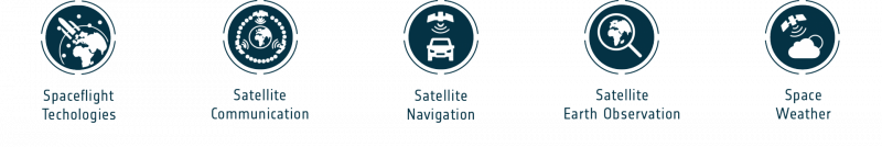
Satellite Communications (SatCom):
- Seamless transition between 4G/5G and satellite communication for V2X and massive info transmission, such as road and safety information in remote areas.
- Satellite IoT (including 5G based) to connect sensors for on field monitoring and connected vehicles.
- SatCom as back up to terrestrial networks (e.g. LMR, LTE, etc.) particularly to address a situation of emergency or disaster.
Satellite Earth Observation (SatEO):
- Provide multispectral images to build HD maps and to further zoom-in in specific areas of interest.
- Provide weather and other environmental parameters and forecast
- Advanced GIS for spatial information management, including utilization of SatEO data to monitor risks along the road (e.g.: environmental risks).
Satellite Navigation (SatNav):
- Ubiquitous high accuracy PNT technologies to support accurate and seamless positioning provided by GNSS, 5G and other complementary terrestrial and on-board systems.
- Track and trace vehicles
- Geo-localize data from IoT sensor networks.
Intended services can integrate space-based technologies with non-space technologies like machine learning, artificial intelligence (AI), and internet of things (IoT).
WHAT ARE WE LOOKING FOR?
The call offers the opportunity to companies to bring forward their business propositions, which will leverage on space and advanced Digital Transformation technologies for delivering sustainable solutions. Funded participation to 4S Strategic Programme Line is open to any company and/or organisation residing in the following Member States: Austria, Belgium, Czech Republic, Denmark, Finland, France, Germany, Greece, Hungary, Ireland, Italy, Luxembourg, Netherlands, Norway, Poland, Portugal, Romania, Spain, Switzerland, and the United Kingdom.
Contact information can be found under: National Delegations.
For more information on the scope and conditions of the call, download the document ‘Satellite Connectivity for Autonomous Land vehicles Safety – Scope’.
Please upload the finalised proposal using the online web submission form.
WEBINAR
- 11:00 CEST, 28 September 2022
- Speakers:
- Roberta Mugellesi Dow - Business Applications Manager at ESA
- Olaf Eckart - Senior Expert Cooperations R&D, Industry Customers at BMW Group
- Susanne Elisabeth Schulz - Head of Department Cooperative, Connected and Automated Mobility at Die Autobahn GmbH des Bundes