
The health of our forests is vital for the environmental and economic health of our planet. An ESA Demonstration Project has enabled sophisticated development of a forest analysis tool based on satellite data and self-learning AI, to support landowners in their duty to improve the health of Earth’s forests.
According to the World Wildlife Fund, forests are vital to life on Earth. They purify the air, filter the water we drink, and prevent erosion. Forests offer a home to a diverse array of plant and animal life. They also provide timber, food, and medicinal plants. But the world’s forests are under threat from illegal and irresponsible logging, poor management, extreme weather, and climate change.
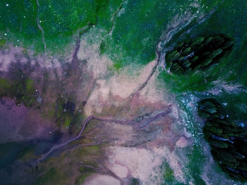
Keeping track of forest health is challenging due to the size and inaccessibility of the landscapes. Traditional monitoring methods, based on field measurements and laser scanning, can be slow; by the time a forest owner can identify concerning data, it is mostly out-of-date.
New goals, new data
Today’s landowners are increasingly interested in more than just the economic profit that can be generated from the forests in their care. Nurturing biodiversity, provision of clean water and protecting the beauty of landscapes are all high on the agenda. Carbon storage is also a priority because forests are a key buffer against climate change.
To achieve all these goals requires new kinds of information, rapidly and regularly delivered. That’s where EnviNavigator comes in – a forest analysis tool combining traditional measures with AI and satellite data to provide information like never before.
Self-learning for greater accuracy
At the core of the EnviNavigator system – developed by Finnish company Bitcomp – is a self-learning AI engine, which helps to achieve what previous calculation methods could not.
The engine trawls satellite images for changes to the forest canopy. When it finds an area of change it assigns a likely cause – say, storm damage. The algorithm then cross-checks against other inputs, such as user feedback and field observations. If these back-up the engine’s deduction – e.g. the forester inputs that the area has, indeed, been damaged in a storm – it learns that the same observations in other locations are also likely to indicate storm damage. However, if the deduction is not backed up by other sources, the engine will learn this is a less likely conclusion from the signals.
Transparency and communication
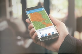
High quality insights are only useful if they rapidly reach the people who can make change. A key part of the EnviNavigator project was to integrate the service into applications used by foresters and forest owners, so that information can be easily accessed.
Through these applications, EnviNavigator automatically alerts sites that need attention. Both foresters and forest owners can have access to the data, enabling greater transparency, agency and understanding of the forest health in both parties.
Sanna Härkönen, the R&D Director of Bitcomp Oy, said: “We do not analyse satellite data and develop artificial intelligence algorithms because it is trendy. We develop services that concretely make forest professionals’ work easier and forest owners’ services better. The EnviNavigator project is not only about satellite data but also about enabling its advantages in field work.”
Project development
EnviNavigator began as a forest change detection service in 2019, analysing physical changes in the environment. The Finnish Forest Centre began using Bitcomp’s service for real-time monitoring of illegal thinning and felling.
Further development of the algorithm was possible with support from an ESA Demonstration Project. Some of the variables added include storm and insect damage, and the system is now able to provide better carbon storage estimations as well as predictions of future forest health based on detection of health risk status.
“The EnviNavigator service is a great example of digital transformation arriving in forestry and using satellite Earth observation data to visualise forest management needs and in this way empowering and involving forest owners directly,” said Volker Schumacher, Business Applications Engineer at ESA.
In Finland, the EnviNavigator AI now covers the whole country. It is set to be made available for all Finnish forest owner associations and their customers through the platform LeafPoint, thanks to a contract with the head organisation of forest owner associations (MHYP).
In Germany, EnviNavigator so far covers the whole country for change detection and vitality mapping services, with deeper insights planned. Here, it will be available as part of the Woodsapp.de solution.