Objectives of the service
In this feasibility study we investigated the potential for the implementation and sales perspective to provide location-based information on the current and future distribution of the ageing population down to the building block level. It was shown that information derived from EO data significantly improves existing census data through a modelling approach based on land use information. Thereby, AgeSpot links EO derived population density with state-of-the art demographic models. The unique approach not only provides spatially explicit demographic data along with information on health and income, but also allows long-term forecasting.
The AgeSpot business intelligence service provides a crucial information basis to efficiently target, place and support other technological solutions as well as existing critical services of telecom providers, insurances, financial institutions, the pharmaceutical industry, health care, and many other companies etc. focusing on ageing population. Thus, AgeSpot bridges the gap between the users’ needs for time series (now to future) of age-specific, geospatially explicit population distribution at city block level and the costs constraints of surveying such data.
Users and their needs
AgeSpot offers a unique proposition in providing a technical solution covering all sectors targeting the “Silver Economy”, including stakeholders such as from health and care, independent living, safety and security, social, leisure and education. AgeSpot enters markets and meets the information needs of both the private and public sectors in fields such as market research, business location analysis, risk assessment and urban and regional planning.
Private sector companies like, telecommunication and insurance companies, as well as companies offering consumer goods, benefit strongly from the information provided by AgeSpot, helping them find out where to offer which specific services and to adapt their supply to the local demand depending on the demographic structures of different regions. For the public sector, AgeSpot data makes it much easier for governments to better meet the needs of regional and district populations. Furthermore, it is an important signpost for taking the right steps to promote local economies.
User’s needs provided by AgeSpot:
- Easy access to accurate and up-to-date spatial data on potential customers down to the building block level.
- Understandable information.
- Cheaper solution than collecting own data.
- Basis for clear, cost-effective, low risk decision-making.
- Professional and reliable future projections.
Potential users belong to nearly all economic sectors operating world-wide on regional to global scales.
Service/ system concept
AgeSpot is tailored to the global demand for business intelligence data, a driving force for economic growth. It enables customers to easily access granular, standardized and up-to-date key information about their target groups providing a new information service for spatially locating and forecasting population demographics.
This information is derived through a system that implements the following key innovative technical components:
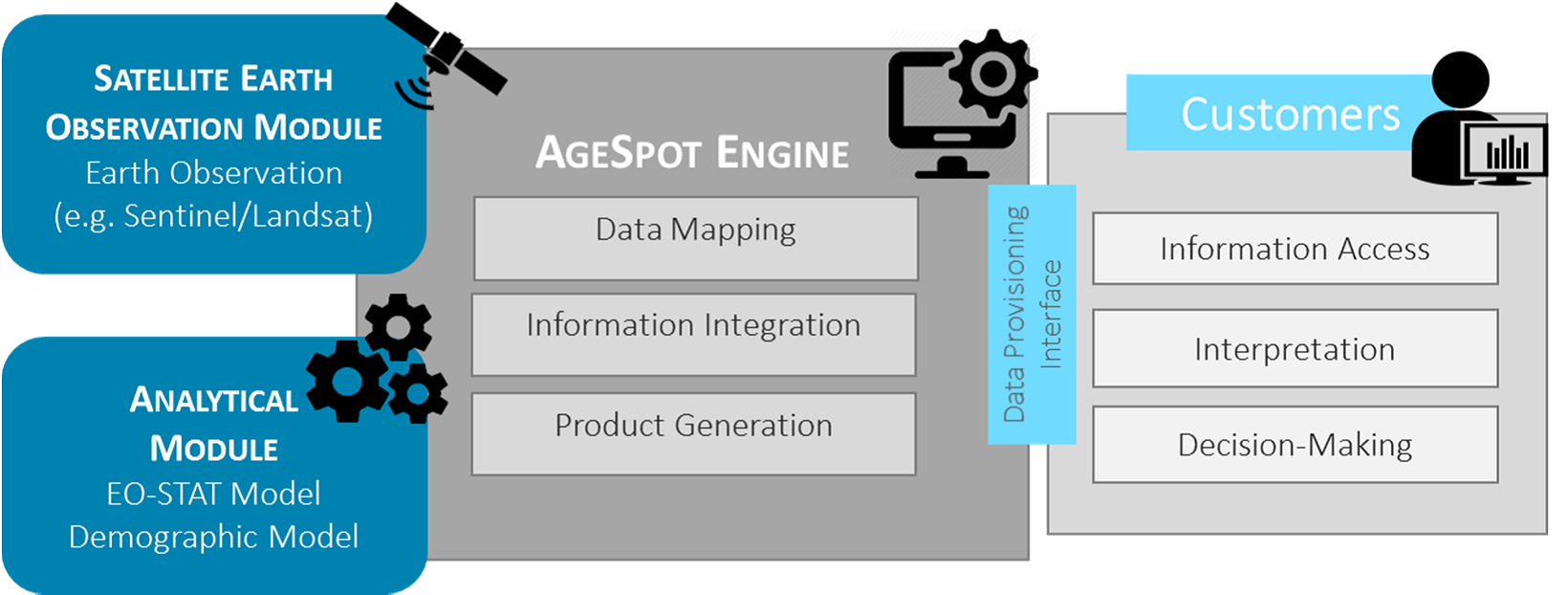
- Satellite Observation Segment: EO derived information enables a service that significantly improves existing census data through a modelling approach based on land use information.
- Analytical Module:
- Population Disaggregation Model: This model provides statistical information about the distribution of the population in their residences. With the help of further data such as building block locations, land use and degree of sealing of the surfaces, a precise, high resolution disaggregation of the population takes place.
- Demographic Model: In a Bayesian Model Averaging (BMA) approach a large number of spatial and demographic variables are identified to determine the number of elderly people on up to a 50m grid level.

Figure 1: High level illustration of the AgeSpot system architecture
Space Added Value
The baseline for this project is the Satellite Earth Observation (EO) component. The EO derived information significantly improves existing census data through a modelling approach based on land use information derived from EO satellite data (e.g. Sentinel). Satellite EO data can extract land use information to a sufficient degree of accuracy to supply the reliable base information necessary for this service. The linking of the data with the statistical information on demography is sufficiently accurate thanks to the pycnophylactic model developed by GeoVille and its continued improvement since first application. This EO modelling tool applies pycnophylactic disaggregation i.e. avoiding error propagation outside the sensor tracts, and thereby guarantees high quality results.
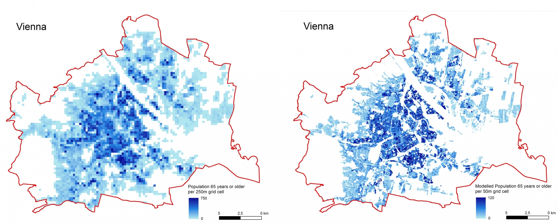
The high resolution EO data provides the basis for products on two different granular levels:
- City View: 50m resolution
- Regional View: 250m resolution

Figure 2: Spatial distribution of people aged 65 years or older in Vienna - reality (left) based on available population statistics (250m resolution) versus AgeSpot model (right) - City View (50m resolution).
Current Status
The Project ended in February 2018. The feasibility study showed that with AgeSpot the population and accurate age structures of any urban or regional entity up to the national level can be reliably disaggregated down to building block scale providing high resolution information on the ageing population or any other age cohort. The information gained through AgeSpot offers a large range of analytical possibilities with a high business intelligence value. The economic viability of AgeSpot could be demonstrated in an associated business plan showing significant potential for a future global roll-out.
Prime Contractor(s)
Subcontractor(s)


