Objectives of the service
The AIDA Feasibility study demonstrates the benefits of developing innovative space-based solutions for damage estimation on crisis affected areas, due to conflicts and natural or man-made disasters. The two AIDA designed services provide to decision makers and humanitarian intervention operators several value-added products, mainly cartographic, in support to the various activities included in the different phases of the disaster management cycle: prevention, mitigation, preparedness, response, rehabilitation, reconstruction and recovery. In particular, damage assessment operations are fundamental in post-crisis early response activities, and effectively support response operations. The proposed solutions, integrating AI capabilities, can quickly process high /very high resolution satellite imagery with a high degree of automatization, and are easy to use and to integrate in existing user systems. Two are the main domains of application of the proposed monitoring services: agricultural areas and critical infrastructures, affected by several types of disasters (flood, hurricane, earthquake, fire, explosion, etc.).
Users and their needs
The final users of AIDA space-based solutions are decision makers working in the emergency field who manage, in a short time, operational aid activities supporting affected communities and post-crisis recovery actions. AIDA services have potentially global coverage. A pilot of the study has been performed in Ukraine.
AIDA solutions provide:
-
Accurate, automatic, rapid and cost-effective damage identification and mapping capabilities. Providing rapid and automatic geodata processing capabilities, exploiting AI frameworks for satellite data analysis, is crucial to support timely emergency management operations, allowing the extraction of required information from huge archives of satellite images and covering wide geographic areas. AIDA solutions support and streamline manual mapping procedures for efficiency gains, addressing limitations in obtainable coverage and accuracies, and reducing production efforts and costs.
-
Easy-to-use, highly customizable, and interoperable solutions, providing effective options for integration in existing systems and workflows. AIDA includes a specific modular web-platform ensuring friendly user interface, for both expert and non-expert users, enabling customised capabilities, the storing and the use of local datasets provided by users and different mapping options. The AIDA services and platform are interoperable with most of the existing operating systems and devices, adopting web and GIS standards. Coupled with the system modularity, this allows the easy integration in external software, services and workflows.
Service/ system concept
AIDA services
-
Service 1
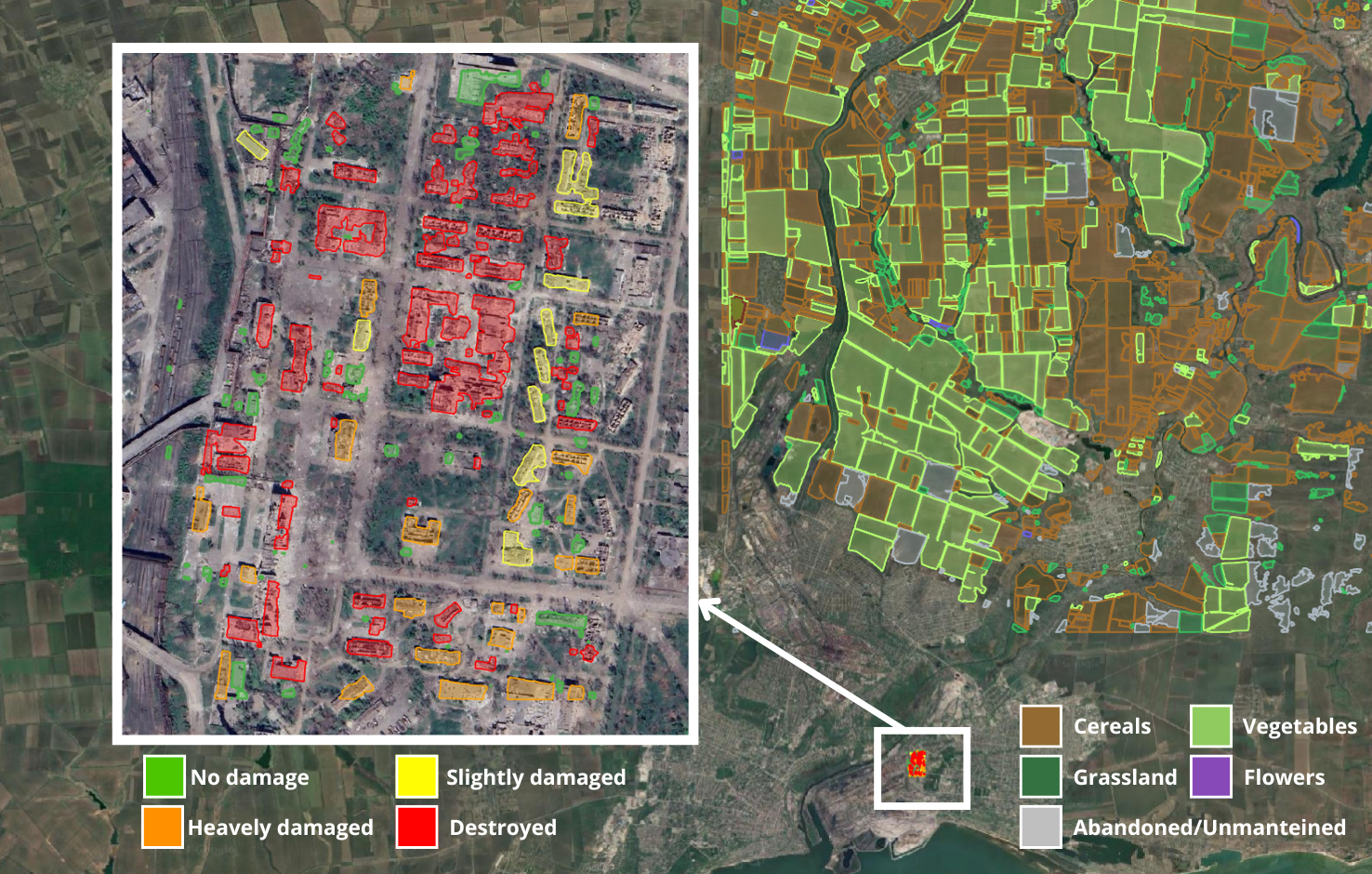
Assessment and monitoring of damages to critical infrastructures → detection and mapping of damages occurred to critical infrastructures, such as buildings, in areas affected by conflicts or natural disasters. The assessment is based on the analysis of very high spatial resolution pre- and post-event satellite imagery. -
Service 2
Assessment and monitoring of agricultural areas → detection of anomalies in agricultural areas. Areas where crop evolution for the examined growing seasons is potentially affected by conflicts or natural disasters are detected and mapped exploiting time-series of free-of-charge and open high spatial resolution satellite images.
AIDA platform
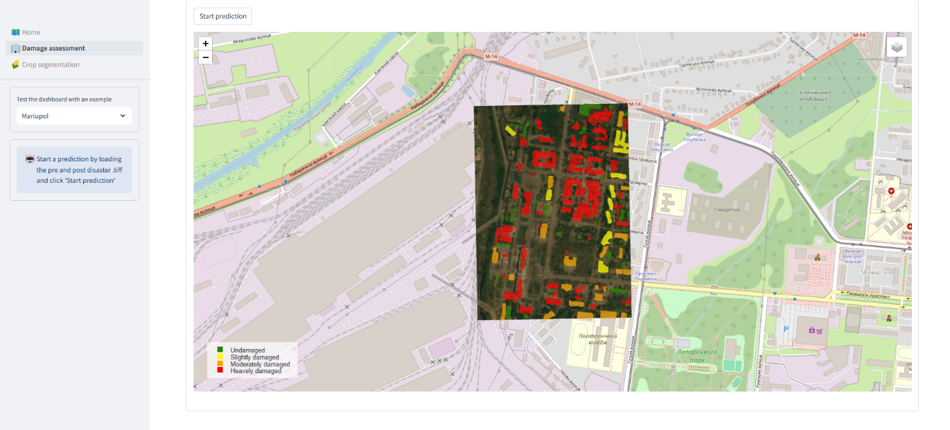
Through the designed interface of the AIDA platform users can navigate areas of interest (AOIs) using tools like zoom, pan, rulers, and search functionalities. To initiate the AIDA damage assessment mapping process, users can precisely define AOIs using a rectangle selection tool, provide specific event dates for satellite imagery research tasks, or upload/select pre-/post-disaster images. The results of the segmentation and damage assessment processes can be then visualized, explored and downloaded. The ease-of-use of the developed platform has been demonstrated during PoC activities. A friendly and ergonomic user interface is essential for users which are not expert in satellite data manipulation, and for expert users who need to work within short deadlines.
Space Added Value
Nowadays, the role of Earth Observation satellites in the monitoring of zones affected by humanitarian crises, induced by conflict or by natural disasters, is duly recognized. Such technology offers indeed precise and accurate remotely derived datasets, thus providing a fundamental aid also in monitoring dangerous areas where the collection of ground-based information is often hard to perform.
Moreover, the adoption of innovative AI methods improves detection and mapping capabilities from satellite imagery, while increasing automation capabilities of the proposed tools, and reducing the manpower and time investment generally required by the traditional approaches applied in this field.
Current Status
Based on the comprehensive analysis presented, AIDA services affirm their technical feasibility and economic viability, and potential for long-term sustainability, particularly taking into consideration their application into the emergency management field. AIDA could offer various commercial exploitation models based on user requirements, ensuring affordability.
From a technical point of view, further actions are envisaged for the system improvement and possible extended exploitation, and they are mainly related to the exploration of Incremental Learning and Domain Adaptation methods, and Super-Resolution techniques.
Furthermore, the project Consortium is currently evaluating the possibility to extend AIDA solutions across different sectors showing a potential high growth rate in terms of market volumes and profits in the long term, including insurance, energy, agriculture, environment, infrastructure, transportation, urban planning, and security, addressing critical needs such as risk assessment, asset monitoring, environmental management, and disaster response, providing substantial value to commercial customers.