Objectives of the service
Journalists and civil society organisations often face barriers when trying to access reliable satellite imagery. Commercial providers typically target governments or large corporations, making it difficult for smaller actors to obtain timely and affordable images. In addition, available imagery often lacks user-friendly tools for clipping, visualising and integrating data into newsroom workflows. As a result, many stories that would benefit from visual evidence remain unreported or unverifiable.
This service addresses these gaps by building a platform that allows registered users to request, search and visualise satellite imagery for specific areas of interest. The platform integrates data access with tools for verification and context, ensuring that images are not only retrieved but also interpretable and defensible. By combining streamlined access with tailored support for fact-checking and storytelling, the service lowers the entry barrier for non-technical users.
The activity will design, prototype and test this service with selected media outlets and civil society partners. The objective is to validate demand, assess willingness to pay, and refine workflows so that satellite-based evidence can become a trusted and practical component of investigative reporting and accountability work.
Users and their needs
The service is designed for investigative journalists and civil society organisations worldwide who rely on trusted visual evidence to document events and hold actors accountable. Current users are drawn from Europe and beyond, including independent newsrooms, international NGOs, and exiled media outlets working on regions where access is restricted. Selected partners will directly participate in the activity to test and refine the service.
User needs:
-
Timely and affordable access to satellite imagery for specific areas of interest.
-
Easy-to-use tools to clip, visualise and integrate imagery into newsroom and NGO workflows.
-
Verification and contextualisation to ensure images are authentic and defensible.
-
Transparent licensing and pricing suitable for limited budgets.
-
Reliable delivery despite varying levels of technical expertise in geospatial tools.
Challenges to meeting these needs:
-
Bridging the gap between commercial satellite providers and non-technical users.
-
Designing simple interfaces without losing analytical depth.
-
Ensuring credibility of imagery in journalistic, legal, or advocacy contexts.
-
Balancing affordability with the costs of commercial imagery.
The activity will involve hands-on collaboration with media outlets and NGOs across multiple countries to validate needs and adapt the service.
Service/ system concept
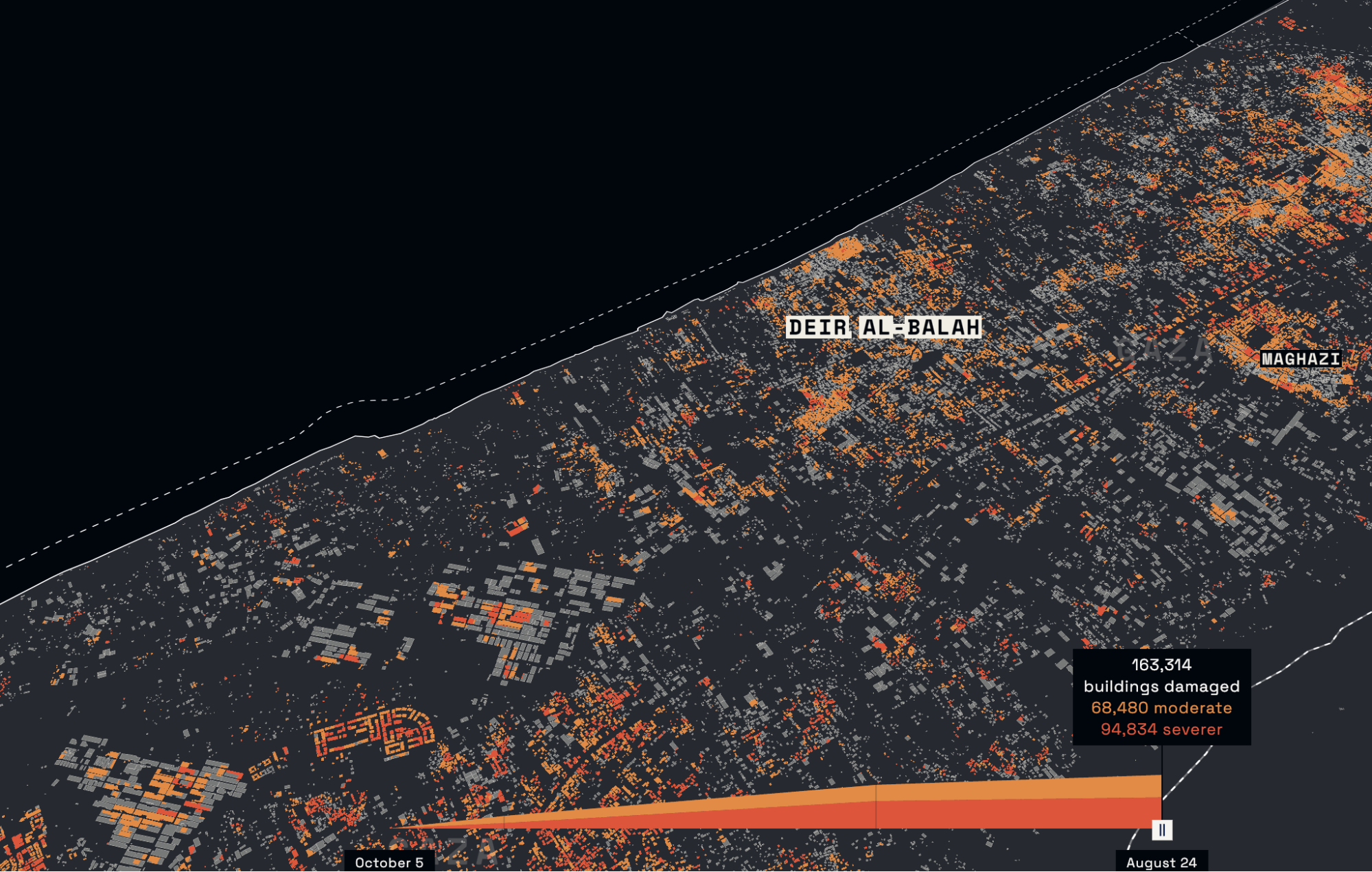
The service delivers more than just satellite pictures: it provides analysed, verifiable evidence from space. Users can request imagery and data products that combine high-resolution commercial images with open sources such as Sentinel and Landsat. Beyond visual data, the service integrates spectral analysis (e.g. vegetation or water quality), thermal data (showing heat signatures such as wildfires or urban heat), and Synthetic Aperture Radar (SAR), which can see through clouds and capture ground changes day or night.
Key capabilities for users:
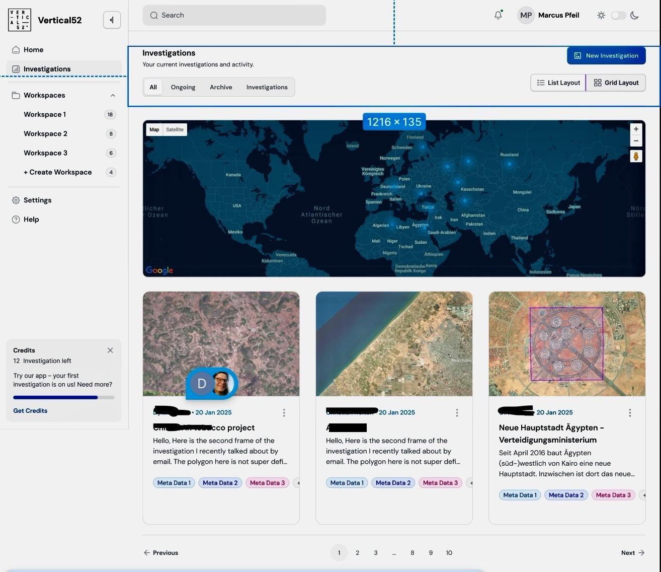
-
Search, order, and display imagery on an interactive map.
-
Apply simple visual analyses such as timelapse, change detection, or before/after sliders.
-
Annotate maps and data products directly in newsroom fonts for immediate publication.
-
Export material in newsroom-ready formats.
-
Verification support to ensure defensibility of visual evidence.
How it works (high level):
-
Users submit requests via the platform.
-
The system connects to multiple satellite providers (commercial and open).
-
Images and data are clipped, analysed, and verified.
-
Users receive a ready-to-use workspace with imagery, context, and annotation tools.
The architecture combines a simple user interface with secue provider connections and a processing layer that delivers evidence-ready visuals, not raw pixels.
Space Added Value
The service combines commercial very high-resolution satellites (e.g. Planet, Airbus) with open missions such as Sentinel (Copernicus) and Landsat (NASA/USGS). Sentinel-2 and Landsat provide multispectral data for vegetation, water, and land-use monitoring; Sentinel-1 delivers Synthetic Aperture Radar (SAR) to detect ground changes even through clouds; and Sentinel-3 and Landsat thermal bands enable heat mapping. These are complemented by high-resolution imagery for detail and visual storytelling.
The added value comes from integrating different space assets into a single service:
-
Multispectral analysis to reveal changes not visible in standard images.
-
SAR data to ensure coverage independent of weather or daylight.
-
Thermal data to capture events such as fires, industrial activity, or urban heat.
-
High-resolution optical data for contextual, newsroom-ready visuals.
Unlike competitors who mainly act as image brokers, this service delivers analysis-ready and defensible evidence. By combining multiple data sources, it provides reliable insight even when one dataset alone would be insufficient. This approach makes space assets practical for journalists and NGOs who would otherwise struggle with raw imagery, enabling them to report and verify events with confidence.
Current Status
The project has established a partnership with Planet, enabling access to very high-resolution imagery for journalistic use. Together with NDR German Television, we completed an analysis of algae blooms in the Baltic Sea to illustrate environmental changes on screen. This collaboration demonstrated both the technical feasibility and the newsroom relevance of our approach.
Currently, we are developing the wireframes for the image and data search interface, which will allow users to specify areas of interest, select time ranges, and retrieve processed products. Early prototypes include interactive features such as timelapse views and before/after comparisons.
Prime Contractor(s)