Objectives of the service
To provide a fast Integrated Situational Awareness Service using space derived data and integrating it with other information sources and delivered through low bandwidth satellite communications rapidly and directly to the point of need. The user community being and not exclusive to, Arctic oil and gas, shipping and tourism industries.
Users and their needs
The activities undertaken in this study are expected to have an impact on any industries operating in the Arctic environment:
- Commercial Shipping Companies
- Oil and Gas operators
- Mining Companies
- Arctic Tourism Companies
- Environmental Organisations
Service/ system concept
- Situational awareness alerts
- Situational awareness information layers
- Situational awareness in-situ data
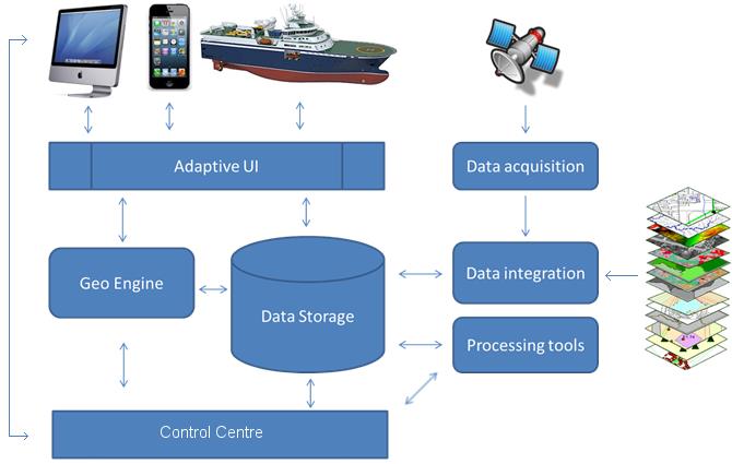
Space Added Value
Satellite Earth Observation data (COSMO-SkyMed & Sentinel-1 primarily) were identified as the EO assets for use in the service and were included in the Proof of Concept. Regarding satellite communications, the Arctic region necessitates the use of Low-Earth Orbiting systems for communication and data delivery since geostationary satellite communications systems cannot provide coverage to the far North. The project concentrated on the use of VSAT specifically Iridium OpenPort/Pilot and this was used during the Proof of Concept to demonstrate the system capabilities. Satellite AIS was a furher satellite system used in the project and which would form a key component of the future service.
Current Status
Complete. Following the completion of the user requirements review, the state of the art analysis, the economic/non-economic viability and the definition of the integrated service, the project concluded its Proof of Concept and defined the roadmap to a future sustainable service. The roadmap identified a number of critical steps that would need to be taken to make a demonstration phase project possible. Work on these steps is on-going.
Prime Contractor(s)
Subcontractor(s)