
Objectives of the service
The service objective is to provide bespoke satellite-based analyses to support news agencies in their news reporting activities on humanitarian and environmental crises.
Especially in conflict or crisis situations, the available information is indeed scattered and disconnected, witnesses can be scarce, remote areas can be difficult to access, and safety concerns can prohibit the presence of independent monitors. As a result, journalists find it difficult to closely monitor the events, due to the lack of sufficiently consistent, comprehensive, and comparable data.
GMV service makes use the latest available images, as well as historical ones, to detect and classify as much actionable evidence as possible from space. To this purpose, the service leverages advanced Earth Observation (EO) and Machine Learning (ML) techniques and validated crowdsourced non-EO data to support the analyses, when made available by the customer.
The service’s geospatial products can be made available along with the EO data in a web portal for the users to get a more comprehensive picture of the matter under analysis.
It is important to highlight that GMV’s service only provides satellite-based objective and quantifiable products, leaving the analyses of the scenarios and the interpretation of the situation to the journalists.
Users and their needs
GMV’s service is targeted at digital media outlets and news agencies dealing with investigative, storytelling and analytical journalism.
A sample of the needs shared by the stakeholders interviewed by GMV are:
-
Have access to geospatial products and EO imagery that is easily "readable", to be able to identify features under analysis;
-
Use EO data to provide unbiased and independent facts to complete and corroborate witnesses’ stories, to lend credibility to a story and add transparency of reporting, especially in remote and inaccessible locations;
-
Use EO data to perform spatio-temporal analyses to monitor phenomena on a macro scale (e.g., regional- or country-level) and bring to light hidden cause-effect mechanisms;
-
Address the issue of scattered and disconnected information;
-
Have access to a tool to visualise, download and explore the EO data and geospatial products.
During the project, a use case was implemented to showcase the service under development in a real-world scenario. The use case was pinpointed by the anchor user as a high-priority application, and provided information essential for their news reports.
Service/ system concept
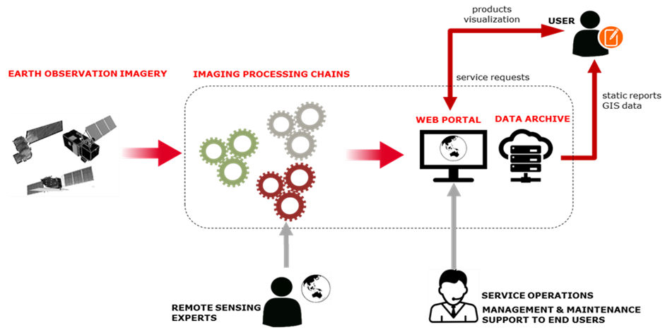
The service combines remote sensing expertise with state-of-the-art machine learning methods to generate valuable data products from raw EO data. The data products can be visualised, explored, and interrogated by the users on a web portal.
Satellite imagery is the core source of data for the generation of geospatial products, and the backend system is a suite of information extraction and enrichment pipelines. The below diagram depicts the information flow throughout the service.
Space Added Value
The space assets utilised in the use case are:
-
High Resolution optical satellite imagery (Sentinel-2 time series);
-
Very High Resolution (VHR) optical satellite imagery.
The processing chain was developed to scan large spatial areas and time series of Sentinel-2 imagery, and automatically identify and extract the feature under analysis.
Sentinel-2 time series data is complemented by VHR imagery to train the machine learning models and validate the results, together with ground truth data (where available).
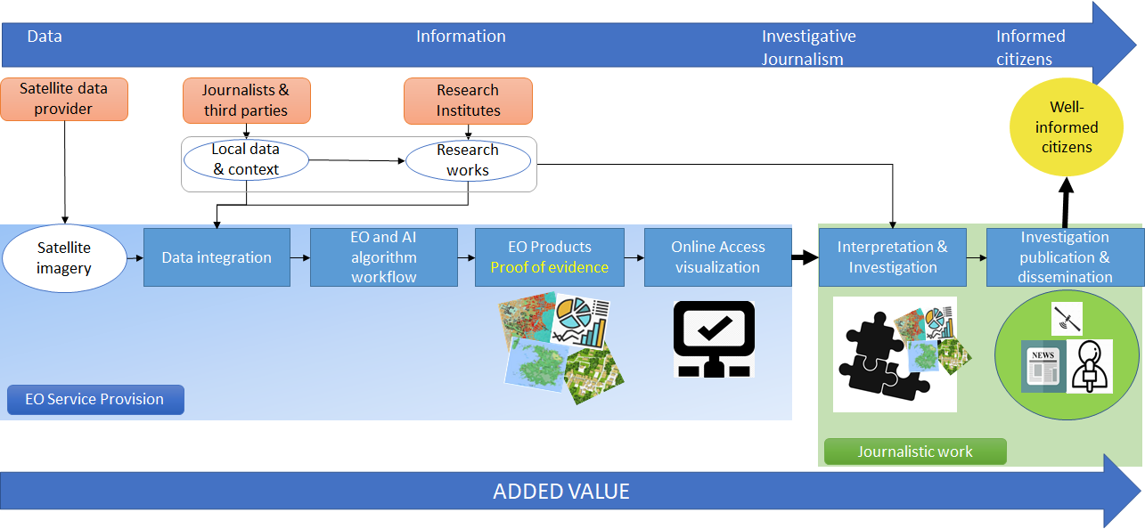
The service aims to allow journalists to work with the EO products and integrate them with other sources of information (local information, testimonies, etc.). All these pieces of information, as pieces in a puzzle, can help them better understand the scenario under investigation. In addition, satellite-based products and data could contribute to discovering certain hidden cause-effect mechanisms (e.g., environmental degradation), and assessing the impact of environmental policies (e.g., the ban on plastic bags, reforestation projects of companies, etc.).
The below diagram provides an overview of the value chain in the service.
Current Status
The CCN activity enhanced the suite of BIGMIG-DEMO services with a new space-based service.
During the project, BIGMIG-DEMO team held interviews with journalists from different media outlets and gathered information on the use of EO data in their daily work. These interviews helped GMV consolidate the user needs of the sector.
The new service was designed to leverage the system and service architecture developed during BIGMIG-DEMO main activities as much as possible. Nevertheless, for the use case identified with the anchor user, the team updated existing components and developed new ones where necessary. Machine learning algorithms were indeed implemented to first classify urban infrastructure and then detect any changes.
The pilot phase concluded positively in April 2023 with the delivery of the geospatial products and a summary report, which included a statistical analysis of the results. The pilot yielded promising results and positive feedback from the end user.
On the marketing side, GMV is currently looking at the rollout of the service by focusing on preparing dissemination material and reaching out to new customers in the media outlets sector.