Objectives of the service
BrightEarth delivers reliable and up-to-date maps at a fraction of the cost of traditional techniques.
Generating 3D geospatial data has traditionally been challenging:
-
Getting accurate, detailed 3D maps is expensive
-
Manually turning satellite images into map data takes weeks
-
Advanced mapping data is only really accessible to enterprises
-
Most organizations still rely on inaccurate open source maps
The following tasks are covered in this project:
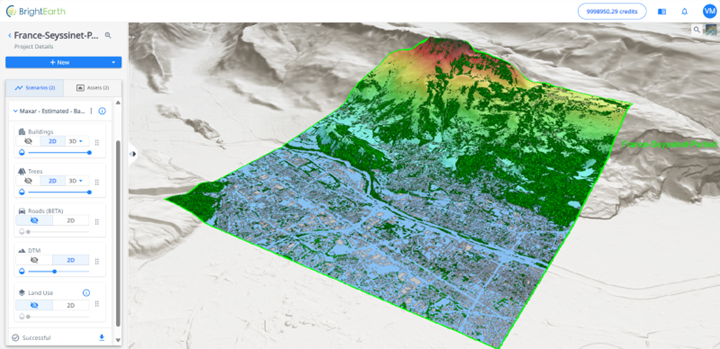
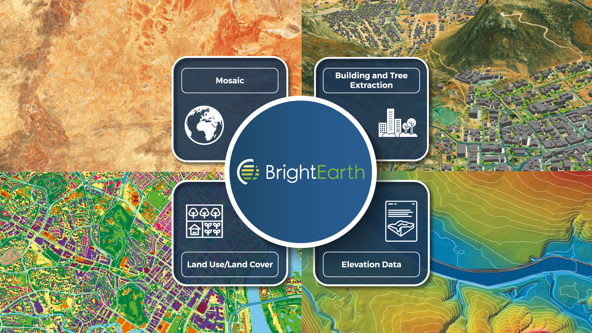
Hi-Resolution:
-
On-demand AI Building, Tree, Road & walls extraction: Based on mono imagery, the quality of heights is “estimated” (standard product)
-
On-demand AI Building, Tree, Road & Walls Extraction: Based on stereo imagery, the quality of heights is “accurate” (premium product)
-
Augmented 3D Cities: This option augment geometry and texture buildings according to heuristic rules and procedural grammars (in estimated or accurate mode)
-
Land Use / Land Cover: Our Land Use / Land Cover dataset consists of 18 distinct classes and is fully compatible with the source imagery.
Low-Resolution:
-
Imagery Mosaic: Our Imagery Mosaic is a seamless and cloud-free global mosaic created using high-resolution Sentinel-2 imagery at 10-meter resolution.
-
Land Use / Land Cover: Our Land Use / Land Cover dataset consists of 14 distinct classes and is fully compatible with the mosaic, including coastlines.
-
DTM: We offer Digital Terrain Models (DTM) as part of our elevation models.
Access via:
-
Web interface
-
API (Application Programming Interface)
Users and their needs
Our ideal client spans a diverse range of professionals worldwide, all united by their reliance on geographic information, specifically those who utilize metric-accurate 3D reference cartographic data.
They are experts with a solid background in geographic data, including Program Managers, Simulation Engineers, and professionals whose roles emphasize Geographic Information Systems (GIS) within their job titles.
These clients seek the most accurate, precise, and up-to-date global data, prioritizing access to high-quality mapping information that aligns with their demand for affordability.
Their fields of application are broad:
-
Defence Training and Simulation Civil flight simulators,
-
Smart Cities, Spatial Planning, Real Estate,
-
Video Games, Entertainment, Digital Twins and Metaverse,
-
Location Based Services or Navigation.
This client profile indicates a need for cutting-edge geographic data to support innovative projects.
This client profile is looking for high-quality, consistent map data, perfectly synchronized with state-of-the-art satellite imagery, to feed your 3D spatial analysis applications.
They are working for example on wave propagation, masking studies, intervisibility, solar exposure, pollutant dispersion or visual representation of urban environments.
They have no time to waste juggling disparate and unreliable data.
Service/ system concept
BrightEarth is based on an innovative cloud architecture, offering a direct, seamless connection to global catalogs of high-resolution satellite imagery providers. This approach enables dynamic access to a wide range of high-definition imagery (from 30 to 70cm resolution) anywhere in the world. In addition, BrightEarth integrates its own pre-calculated Global Base Maps at 10-meter resolution, enriching its data arsenal.
To meet the growing demand for derived data, BrightEarth uses a parallel distributed computing architecture. This method enables fast, scalable generation of cartographic data from satellite imagery, offering a solution suitable for all types of user.
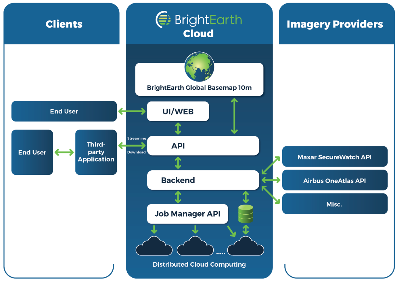
BrightEarth not only provides data, it also offers an exceptional user experience. Its user-friendly web interface offers intuitive access, while its API makes it easy for third-party applications to connect.
Space Added Value
The BrightEarth platform exploits a wide range of Earth observation data to provide solutions at two distinct scales. On a global scale, it draws on Sentinel2 images and altimetry data from the Copernicus program, as well as data from the ALOS program. For more precise local coverage, it takes advantage of the ever-growing range of high-resolution images offered by the historic players in the resale of earth observation images (AirBUS/Maxar) as well as by the new players in the New Space sector.
The added value of using satellite imagery for mapping is twofold. Firstly, it offers worldwide coverage, eliminating the constraints associated with flights by plane, helicopter or drone, such as overflight restrictions. Secondly, the multiplicity of players involved in the supply of images optimizes their availability and freshness.
By combining these spatial assets, BrightEarth offers precise, up-to-date mapping solutions, tailored to both global and local needs. This approach overcomes the traditional limitations of terrestrial mapping, offering unrivalled perspectives for planning, monitoring and decision-making in diverse sectors such as urban planning, agriculture, natural resource management and many others.
Current Status
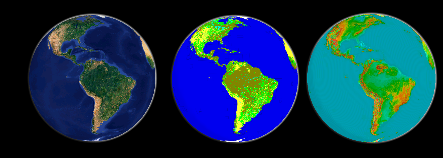
The project's three Global Basemaps have already been created and are stored on the Amazon architecture. They include a global mosaic of Sentinel-2 imagery, a land-use map and a digital terrain model, all at a resolution of 10 meters, which represents a challenge due to the volume of computing involved.
We recently announced the release of BrightEarth On Demand v2.4.0-beta, as part of our Early Adopters program! This latest release is packed with exciting new features and enhancements designed to give users even greater control, accuracy and flexibility in the analysis of their geospatial data.