Objectives of the service
DateGIS information service provide date farm and palm tree information products, for the following end uses:
- Provide insight in basic farm information, such as farm borders, palm field maps, and number of date palms. The information products includes spatial date farm information. The use of satellite remote sensing data in generation of date farm information is a key asset.
- Support the regional RPW monitoring, control and eradication by providing information on the regional RPW spread. The RPW forms an insidious and destructive plague for the national date sectors. The use of remote sensing is a new (disruptive) approach in the development and management of national RPW control programs.
- Support RPW control activities at farm level with information on RPW infestation of (individual) date palm trees. Simple and effective pinpoints to identify infested palm trees on a map allow the immediate start of the treatment or disposal of infested date palms.
Users and their needs
DateGIS information service enables economic growth of the global date sector. The end users that benefit most from date sector growth are the date farmers and government stakeholders liaised to the date sector (such as the Ministry of Environmental, Water & Agriculture and related departments, agriculture R&D organizations).
The date farmers are designated end users and can be segmented in two groups:
- Large farmers, typically commercial and industrial, with more than 20,000 palms, characterized by non-resident ownership, and often belonging to an industrial or commercial agriculture organization. Most of these farms are open for adopting new technology and innovations if it helps them to improve their yield and reduce the losses of (RPW) plagues;
- Small farmers, usually traditional and family driven; for this group it is important that the government must implement incentives, legislation and “push” new technology and innovations to control (RPW) plagues.
The government stakeholders need information to support the date sector to enable growth and eliminate impediments for growth. The DateGIS information service can help them with their following needs:
- Factual date farm information, to develop a growth policy for the date;
- Information on RPW distribution, as currently the main thread to the date sector.
The DateGIS information service is targeted to date producing countries in the Middle East and North Africa.
Service/ system concept
The main DateGIS services developed is mapping and registration of date palm trees and date farms, and Integrated Pest Monitoring (IPM) services using geo-spatial information, date palm data time series analysis.
The operational workflow for mapping and registration of date palm fields in the DateGIS platform.
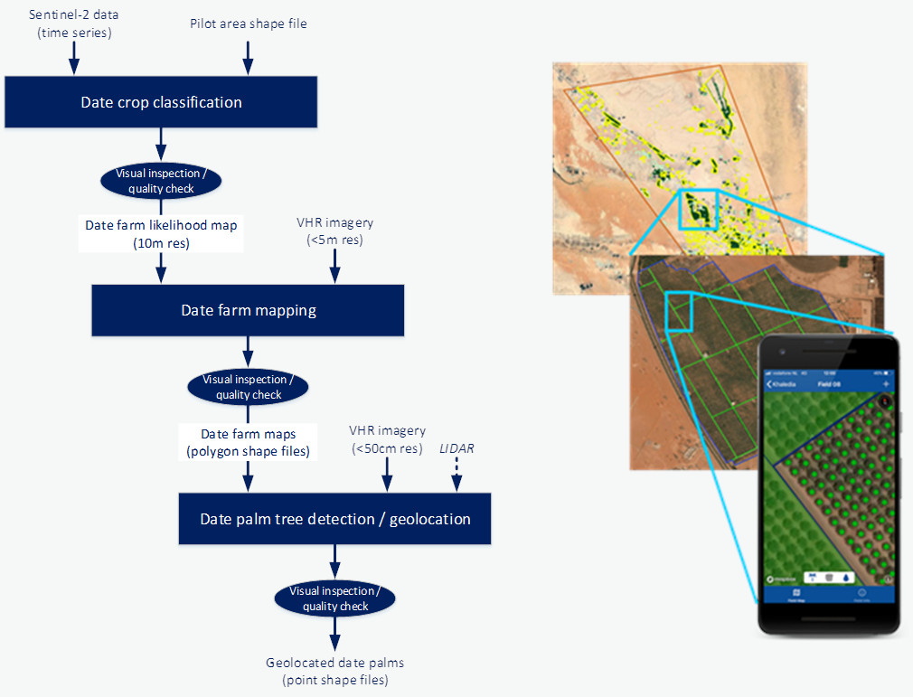
The DateGIS implementation procedure to support IPM at farm or regional level consist of:
- Field registration - Mapping and registration of the date palm fields.
- Field surveys – Understand the working procedures, quality-, irrigation- and pest-management measures already in place.
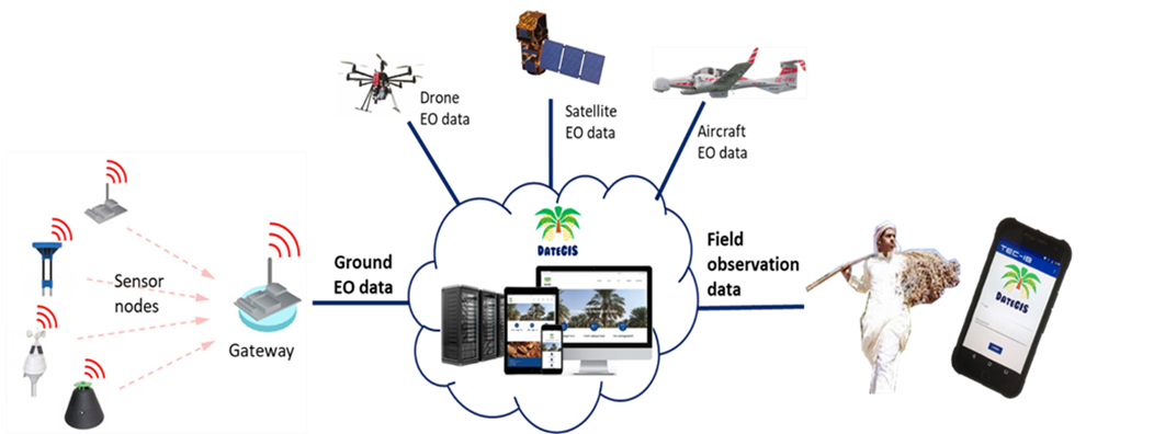
- Data acquisition - Relevant data acquisitions utilizing mobile devices for in-situ data by farmers, extension workers and field workers, and (if available) satellite, aerial and ground sensor data.
- Monitoring - Monitor and control the treated date palms/fields determining the effects of the measures put in place.
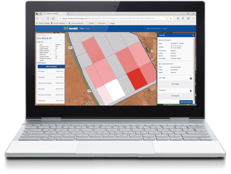
The DateGIS web portal and mobile app provide information on the health conditions of the date palm fields. In collaboration with local agriculture service providers and crop protection agents an IPM system is implemented for effective control of RPW.
Space Added Value
DateGIS extracts information on date palm areas from satellite and (if available) aerial EO data.
Data on date palm health may come from visual inspection (using the DateGIS mobile app) and additional satellite, aerial and ground sensor EO data.
Current Status
The DateGIS demonstration project is completed, with operational pilot services at several date farms the Middle East North Africa region, with potential follow-ups for paid services.
For short term growth potential it is envisaged to use the DateGIS platform in combination with IoT ground sensors for RPW detection. From a related ESA kickstart study SIPECON (Sensor Information for Pest Control), it appeared that a cost-effective IoT sensor network (“Smart RPW Traps”) for automatic detection of captured RPWs in combination with DateGIS provides a viable solution for reliable pest data collection.
Such a hybrid approach offers DateGIS solutions on the short term (based on capturing visual observations and combined with ground sensor data) with a long-term potential by combining it with satellite and aerial EO data input sources.
Prime Contractor(s)