Objectives of the service
DateGIS information service provide date farm and palm tree information products, for the following end uses:
- Provide insight in basic farm information, such as farm borders, palm field maps, and number of date palms. The information products includes spatial date farm information. The use of satellite remote sensing data in generation of date farm information is a key asset.
- Support the regional RPW monitoring, control and eradication by providing information on the regional RPW spread. The RPW forms an insidious and destructive plague for the national date sectors. The use of remote sensing is a new (disruptive) approach in the development and management of national RPW control programs.
- Support RPW control activities at farm level with information on RPW infestation of (individual) date palm trees. Simple and effective pinpoints to identify infested palm trees on a map allow the immediate start of the treatment or disposal of infested date palms.
Users and their needs
In the end DateGIS information service enables economic growth of the date sector. The end users that benefit most from date sector growth are the date farmers and government stakeholders liaised to the date sector (such as the Ministry of Agriculture and departments, agriculture R&D organizations).
The date farmers are designated end users and can be segmented in two groups:
- Large farmers, typically commercial and industrial, with more than 20,000 palms, characterized by non-resident ownership, and often belonging to an industrial or commercial agriculture organization. Most of these farms are open for adopting new technology and innovations if it helps them to improve their yield and reduce the effects of (RPW) plagues;
- Small farmers, usually traditional and family driven; for this group it is important that the government must implement incentives, legislation and “push” new technology and innovations to control (RPW) plagues.
The government stakeholders need information to support the date sector to enable growth and eliminate impediments for growth. The DateGIS information service can help them with their following needs:
- Factual date farm information, to develop a growth policy for the date;
- Information on RPW distribution, as currently the main thread to the date sector.
The DateGIS information service is launched in the Kingdom of Saudi Arabia, as one of the world’s main producers of dates.
Service/ system concept
The DateGIS information supply chain is illustrated in the following picture.
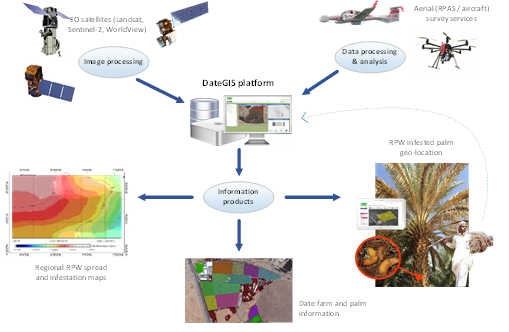
In the center is the DateGIS platform, which generates the information products relevant to the different end users, the date farmers and the government stakeholders. The information products, generated by DateGIS, can be reports, images, maps, numeric data, etc. depending on the end use.
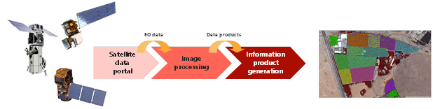
Farm related information products can have different satellite data sources:
-Multi-spectral satellite data for palm vegetation detection;
-VHR satellite imagery for palm tree geolocation.
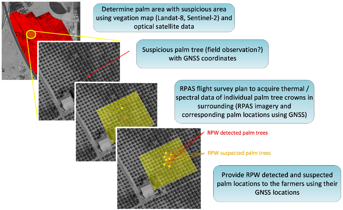
RPW related information products requires high-resolution aerial data (hyperspectral, thermal) preferably on a regular basis. Local aerial survey providers will collect this data using RPAS. Using the palm tree geolocations and GNSS positioning of the RPAS, EO images of designated palm trees can be analyzed on infestation. The infested trees are pinpointed on the map of the farm or palm field.
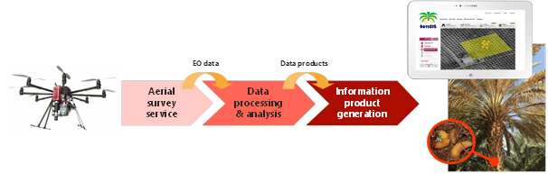
Note that farmers or field workers can also provide specific tree data, like RPW observation reports including photos, using their personnel GNSS device (typically a smart phone).
Space Added Value
The key question for the DateGIS end users is whether RPW early detection is feasible using remote sensing?
Recent studies showed that early detection of infected palm trees with aerial EO images of the palm crown could be feasible even when symptoms are not yet visible. These results are promising, yet it has been conducted in an experimental (controlled) setting with only a few palms in a lab environment.
The practical implication of the acquisition of aerial EO imagery of palm crowns in a reasonable amount of time is substantial. There are tens of millions of date palms which are all susceptible to RPW. It requires decades of “drone-years” to acquire data of all palms, and this should be done regularly!
But in practical situation we often know where some suspicious palms are located and where to look, and our suggestion is to deploy an “RPW early detection drone team” effectively, and upon detection of infestation follow this by a “RPW eradication team”.
The use of space assets is mandatory in this approach, and is disruptive in effective RPW control!
Current Status
This feasibility study was completed November
Prime Contractor(s)