
Objectives of the service
DeSIRE II, Second Element of the ESA EDA RPAS Demonstration Roadmap aims at developing and demonstrating services based on a Remotely Piloted Aircraft (RPA) flying in Beyond Radio Line of Sight (BRLOS).
The project aims at:
- supporting the regulatory process within the European context, with focus on BRLOS operations under Instrument Flight Rules (IFR) using satellite communications;
- demonstrating to selected users the potential of RPAS complemented by satellite applications (Satcom, Satnav and Earth Observation) for developing new services for operations ready to be started operationally after project completion.
From a regulatory perspective, the project has more specifically the objective to contribute to demonstrate that the Satcom link, allowing safe BRLOS Operations, is a key enabler for RPAS insertion into civil traffic.
In particular the aim is to provide the first set of Required Link Performance (RLP) parameters for the RPAS C2 link (including ATC relay) following the guidelines provided by JARUS, in BRLOS conditions via a dual satcom link.
Further to this, the project aims at gathering the user requirements on a service market perspective, also considering the actual operational gaps within users’ operational environment in the Border Control, Law Enforcement, Fisheries Control and Fire events framework.
Project objectives are pursued by means of a real flight campaign using Piaggio Aerospace P.1HH RPAS, complemented by simulation and emulation activities.
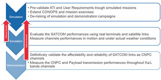
Demonstration Campaign Structure
Users and their needs
DeSIRE II is supported by a wide range of RPAS potential users and regulatory stakeholders from different countries (Italy, Switzerland):
- Italian Coast Guard (IT)
- Guardia di Finanza (IT)
- European Fisheries Control Agency (EFCA)
- Italian Civil Protection (IT)
- CEREN (Centre d’Essais et de Recherche Entente pour La Foret Méditerranéenne)
- ENAV - Italian Air Navigation Service Provider
- ENAC - Italian Authority for Civil Aviation Safety
- EUROCONTROL
- EASA
Users participated in the consolidation of the users, mission and regulatory requirements and in the review of the project results, lessons learnt and recommendations. Dissemination actions were performed to support the regulatory progress on Air traffic insertion.
Users were involved in the demonstration of services capabilities enabled by RPAS in the following operational scenarios:
- Search & Rescue in the framework of Border Control
- Illegal Trafficking in the framework of Law Enforcement
- Fisheries Control
- Fire Prevention and Monitoring
Services considered during the project include:
- Real time video streaming services, acquired by the RPAS, made available to the End Users at their premises
- Near-real Time/Off line Value Added Services (VAS), based on:
- Earth Observation satellite,
- ancillary data (AIS, VMS, LRIT and met-ocean data),
- EGNOS derived satnav enhancement
- RPAS acquired data
The VAS Processing Centre integrates the above data making available in near real time the VAS to the End Users, through FTP/Webgis dedicated secured access interfaces.
Countries of the targeted Users: Italy, Switzerland, France, European Mediterranean Countries/Institutions.
Service/ system concept
The objective of DeSIRE II project is to demonstrate the effectiveness of a satellite communication system for RPAS able to fulfil the requirements for traffic insertion and ATC communication in BRLOS operations. During the flights, the RPA follows IFR rules and is controlled by the ATC.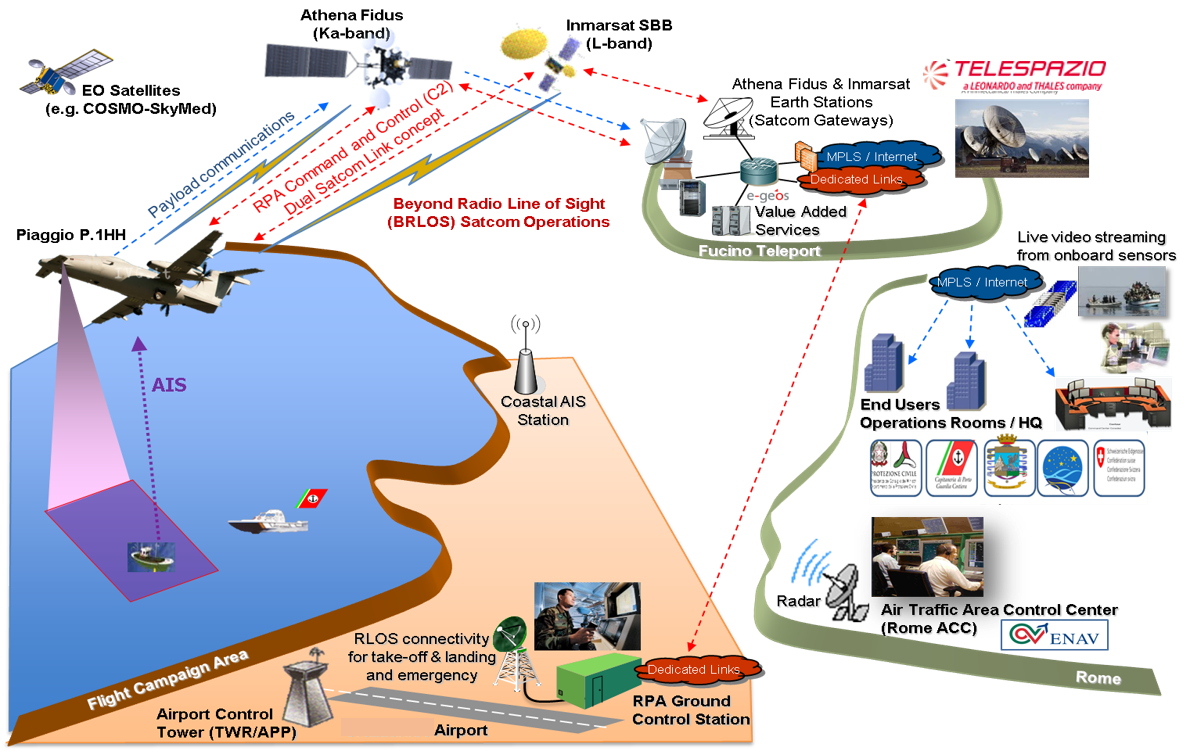
System Architecture
System Architecture is structured into the following building blocks:
- Remotely Piloted Aircraft System segment
- Space Segment
- Ground Segment
In the considered architecture:
- mission data gathered by the RPAS (i.e. EO/IR, AIS, EGNOS) are transferred to the End Users “decisional” network through the Ground and Space Segment;
- the communications between the Remote Pilot and the ATC Controllers are relayed through the RPA.
The RPAS Segment is composed by the Piaggio Aerospace P.1HH Prototype Remotely Piloted Aircraft (RPA) and its Remote Pilot Station (RPS).
In addition to the currently integrated RLOS datalink connectivity, the P.1HH RPAS is equipped with the elements necessary to perform DeSIRE 2 mission tasks:
- BRLOS connectivity: Ka-band and L-band Satcom datalinks and terminals
- Navigation system: GPS/EGNOS receiver
- ATC relay: VHF Radio
- Mission payload: EO/IR sensors, AIS receiver
The Space Segment of DeSIRE II is composed by :
- Communication Satellites operating in Ka-band (i.e. Athena Fidus) and in L-band (i.e. Inmarsat I-4) supporting Command and Non Payload Communications (CNPC) and Payload communications
- EO Satellites (i.e. COSMO-SkyMed constellation and ESA Sentinel satellites) providing both Synthetic Aperture Radar (X and C bands) and optical data sources
- Navigation Satellites (e.g. EGNOS) providing accurate position
The Ground Segment is composed of five main elements that are needed to control the operation of the mission, the integration of the RPA in the airspace and the mission data exploitation:
- Ka-band Satellite Gateway hosted at the Fucino Teleport, which is at the centre of the Ground Segment Architecture and connected to the RPA through a dedicated terrestrial link
- The L-band Satellite Gateway hosted also at the Fucino Teleport.
- Navigation Satellite System (SatNav) centre able to process data coming from the on-board receiver.
- The Value Adding Services (VAS) Processing Center where the payload data gathered during the missions are processed and made available to Operational Centres of the Users
- User Interface Networks which are used to transfer the data derived from the RPA payload in real time and the value added data in near real time.
Space Added Value
Communication satellites are key to provide Beyond Radio Line Of Sight (BRLOS) connectivity, to allow:
- Air vehicle Command and Control from the Remote Pilot Station
- Communications between the Remote Pilot and the ATC controller by means of BRLOS ATC Relay
- Real time and near real time availability of data acquired by means of the RPA sensors in the User Network to answer their operational needs
EO satellites data are integrated with RPA Payload Data and other ancillary data to provide value added products to the users.
In addition, by processing EGNOS augmentation data, a very high accuracy and integrity is offered, potentially enabling precise flying in all phases of the flight and improving services offered to the user community.
Moreover, the processing performed on ground using EGNOS Data Access Service (EDAS) data allows to validate the GPS navigation message received from the RPAS.
Current Status
The project was kicked-off on 9th April 2015 and was completed in November 2018.
The main outcomes of the DeSIRE II project were related to the characterization of SatCom channels, i.e. Ka and L band separately and combined (dual link) in terms of latency, continuity, integrity, and availability. They were achieved during the emulation campaign where more than 100 hours of CNCP traffic tests were collected and analysed. The applied methodology for RLP parameters assessment and the results obtained, in particular from the Emulation phase, should be considered an important input for Standardisation and Regulation purposes and could be the basis of future Acceptable Means of Compliance for the upcoming Regulation.
There are nevertheless several validation activities still to be done in the Emulation and in the Flight test phases, in order to gather a wider set of data that can be considered statistically relevant for RLP assessment. Real-time Simulations using the datalink performances and with more complex traffic environment and emergencies would also be relevant.
The Demonstration Flight Campaign carried out at Birgi airport in Trapani, Italy, by Telespazio and Piaggio Aerospace in March 2018 (outside the Contractual Frame) confirmed the positive feedback on the usage of the satellite technology for BRLOS operations, as outlined by the P1HH pilots remotely controlling the RPA via satellite during the en-route phase, including several flight manoeuvres, and for various dual-use applications under realistic conditions. The success of the trials represents a step towards a future where remotely-piloted aircraft can be used to support public services, such as environmental monitoring, surveillance, and emergency management
Prime Contractor(s)
Subcontractor(s)