
Objectives of the service
The initial goal of the EFFORS project was to develop a real time flood forecasting service for small and medium size alpine catchments to allow users to prepare for upcoming flood events.
Within the EFFORS demonstration project the challenging task of real-time forecasting of spatially highly resolved hydrodynamic data was tackled.
This system includes real time precipitation and river gauge observations, satellite and terrestrial communications, modelling tools and geo-information systems fed by earth observation data from space and terrestrial sources as well as interfaces to the users’ operations command facilities. Within a coherent modelling chain (Meteorology (input) – Hydrology – 2D Hydraulics), the EFFORS system couples the individual numerical models and provides relevant data about flood evolution on short time scales.
The EFFORS service solution is intended to protect critical infrastructure and is aimed at infrastructure operators such as railway and motorway operators, industrial companies and hydropower operators as well as public institutions (authorities for disaster control centres, municipalities, water authorities, disaster control units) and private individuals.
During the project a pilot service was implemented at three pilot catchments with a calculation time of 15 to 60 minutes. Pilot users in the three areas could verify the service during a trial phase.
The project was developed by an international group of engineers and researches and is operated at the computational centre of the Austrian national weather service GeoSphere Austria.
Users and their needs
EFFORS Users and User Requirements:
Stakeholder types involved during the demonstration phase of the project:
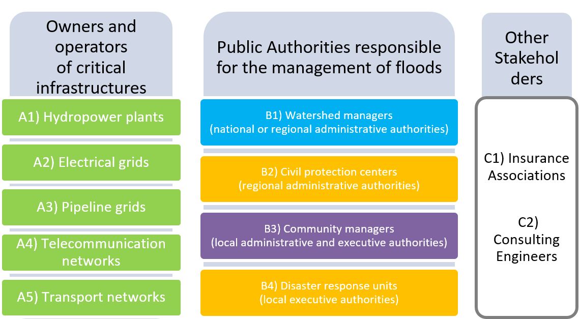
Figure 1: The different stakeholder types of the EFFORS service
The EFFORS Pilot Service was established in three pilot catchments. The Muerz valley (1500 km²), the Kainach valley (850 km²), both located in south eastern Austria and the Berchtesgaden catchment (370 km²) in southern Germany.
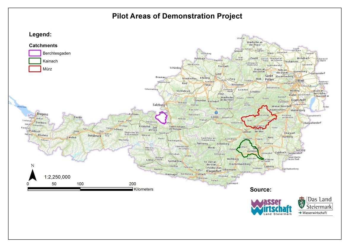
Figure 2: EFFORS pilot catchments
Actively participating users of the pre-operational test phase are listed below:
-
OEBB (Austrian Federal Railways)
-
Austrian motorway operator (ASFINAG)
-
Regional Hydrological Service of Styria (OSGH, watershed manager)
-
The Department for Disaster Warning and Management of the government of Styria
-
Energie Steiermark (Hydropower plant and electrical grid operator)
-
Voestalpine Tubulars GmbH & Co KG
-
Breitenfeld AG
-
Fire department, City of Graz
-
Markt Stanz
-
Markt Krieglach
-
City of Kapfenberg
-
City of Bruck an der Mur
-
Markt Altenberg
-
Markt Langenwang
-
Markt Mooskirchen
-
City of Baernbach
-
City of Voitsberg
-
Traunstein Office for Water Management/ Wasserwirtschaftsamt (WWA)
EFFORS has been developed in close cooperation with potential users. The identification of specific needs of customers/users who participated in the demonstration phase already started in the feasibility study. At the beginning of the demo project users were invited to give an update on the user requirements. During the pre-operational test phase the users were asked to make suggestions for potential modifications. Telephone calls and email information provided close contact with the users.
Based on the two workshops in Graz and Berchtesgaden 2014 (as part of the EFFORS feasibility study) and the updated results of the demo-project, the users/customers expected the following improvement perspectives to be provided by an EFFORS system:
-
24/7 service, email/SMS warning
-
Water level graphs at river points and at floodplain points
-
Discharge rate in the river and floodplain
-
1-day forecasting period
-
Information update interval, 1h
-
Access of the information by users
-
Service hosted by a public or semi-public authority
-
Low water discharge rate
-
Three-level warning structure: At first weather and heavy rain warnings to initiate defensive measures, second information on water runoff and third info on point and/or plain flooding
The contribution of the involved users to the demonstration project was of vital importance for the success of the project. User feedback was given from the early beginning until the end of the demonstration phase.
Service/ system concept
EFFORS Service products
To give the customer the opportunity to choose the type of information he needs, the service provider (GeoSphere Austria) established a three level warning system in the context of three service products:
1. Service product heavy rain warning
-
SMS/Email warning of large amounts of precipitation in a short time for freely definable spatial areas and threshold values.
-
24/7 warning service with spatially and temporally high-resolution precipitation forecast (RAPID INCA 1 km, 5-minute update)
2. Service product heavy rain warning, discharge forecast and warning
-
Heavy rain warning (see service product 1)
-
Real time 1D - discharge / water level forecast (24 hours) and analysis (48 hours) in the river course (up to 15 min update)
-
24/7 warning service via SMS/Email and Web Portal
3. Service product heavy rain warning, discharge and flooding forecast with warning
-
Heavy rain warning (see service product 1)
-
Real-time 1D - discharge / water level analysis (48 hours) and forecast (24 hours) in the river course
-
2D flood area forecast incl. water depth forecast for 24 hours (up to 30 min update)
-
24/7 warning service via SMS/Email and Web Portal
Warnings of critical water levels and flow rates are transmitted to the user by SMS. The EFFORS web portal provides comprehensive information, for example on the development of individual parameters over time.
Innovation and Benefit for the User:
-
Heavy rain warning (Rapid-INCA: 5-min update) for smaller catchment areas < 100 km²
-
Discharge and water level forecasts at any point along the river and water level in flooded areas
-
Real-time modelling of flood plains based on precipitation and runoff forecasts
-
Presentation of the forecast in the web portal and customer-specific warnings via SMS/Email
-
Added value through increased advance warning time for the users and redundant data transmission via satellite
The EFFORS System: Overview
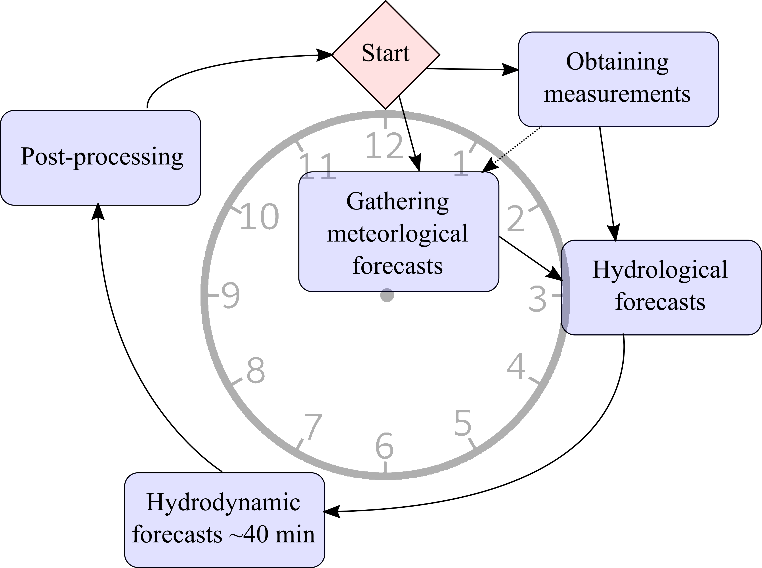
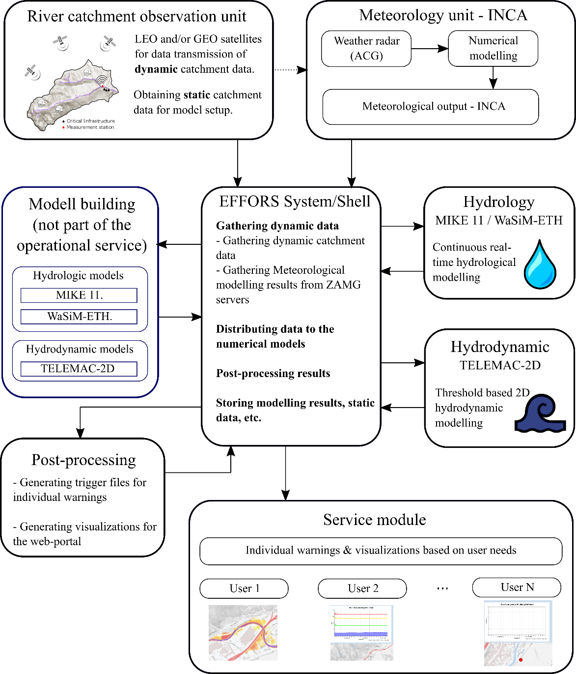
The EFFORS system produces not only hourly updated 24-hour forecasts of heavy precipitation, discharge within the river but also local flood plains. To achieve this, EFFORS uses earth observations in combination with a numerical forecast model chain. The individual parts are linked with a C++ / Python program, which gathers required data for the operational service, provides interfaces between the modules, performs post-processing tasks and stores relevant data. Within this publication this program is further referred to as the shell. At the full hour, the shell first gathers required information from catchment observations and the numerical results of the meteorological model. Afterwards the data are fed into the hydrological model. The hydrological results form the boundary conditions for the hydrodynamic part, which with 40 minutes of computation time requires the most resources and thus, is the bottleneck of the update interval. After that, the model results are post-processed and updated within the web-portal. Furthermore, warnings are sent out if predefined threshold are exceeded. Figure 3 shows a rough overview of the performed tasks, whereas Figure 4 gives a more detailed insight into the EFFORS system architecture.
Catchment observations
Measurements and earth observations form the first part of the EFFORS system. Generally, it has to be distinguished between static and dynamic catchment data. Static data are all information of the catchment, which is required to build, calibrate and validate the numerical models. All static data are available within the EFFORS database. If there are relevant terrain or infrastructure changes within the catchment, the numerical models are revised and further updated during the operational phase of EFFORS.
On the contrary, dynamic data are all information required for the real-time operation of the service, such as meteorological observations or discharge measurements from gauges. In order to enable a redundant service, dynamic data are transferred to the service provider (GeoSphere Austria) via terrestrial communication but also by means of satellite technology.
EFFORS numerical model chain
Meteorology
As for the meteorological part the forecasting model INCA is used. INCA provides information of temperature and precipitation with a spatial grid resolution of 1 km. The temporal resolution is one hour. To predict heavy precipitation events INCA provides the option to work with a 5-minute resolution with a maximum forecast period of 1 hour. For such a short period the results are mainly obtained by weather radar measurements and high resolution precipitation observations.
Hydrology
Within EFFORS two different hydrological models are used. One is DHI Mike 11 the other one is WaSiM-ETH. The WaSiM model is operated on a Linux based operating system, whereas Mike 11 is operated on a Windows machine.
Hydrodynamic
The 2D depth averaged hydrodynamic modelling is conducted with the open source software TELEMAC-2D. The software is highly adaptable, scales well even with higher number of cores and thus, is well suited for operating in real-time mode. For the areas of interest a unstructured triangular grid was created. Because of the very limited available computation time high quality numerical grids are required. Furthermore, appropriate numerical settings and schemes are chosen to allow efficient computation (time wise) whilst providing maximum accuracy and stability. To save computational resources, the two dimensional model is only operated if a certain discharge is forecast by the hydrological model. After the decay of the hydrograph values the model stops operation and is set back to its initial state. This comes with the benefit of resetting the model which is required since certain physical processes like infiltration or evaporation are not considered.
Post processing
Within the post-processing module, user specific data is extracted from the modelling results. The results are visualized in the web-portal but also warnings via SMS or E-Mail, which are based on individual thresholds, can be sent out. Furthermore, all relevant data for reproducing past events is stored.
EFFORS user specific results
The results of the numerical models contain much spatially and temporarily highly resolved information. This allows highly customized visualizations and warnings of individual users. The currently available results are described hereafter.
Weather information and heavy rain warning
Within the web-portal spatially distributed meteorological forecasts of temperature, precipitation and snow line are available. The forecast horizon for weather information is 3 days and the temporal resolution is one hour.
Additionally, higher resolution forecasts are available for the next hour. This highly resolved forecast is also used to generate E-mail and SMS warnings for heavy rain events.
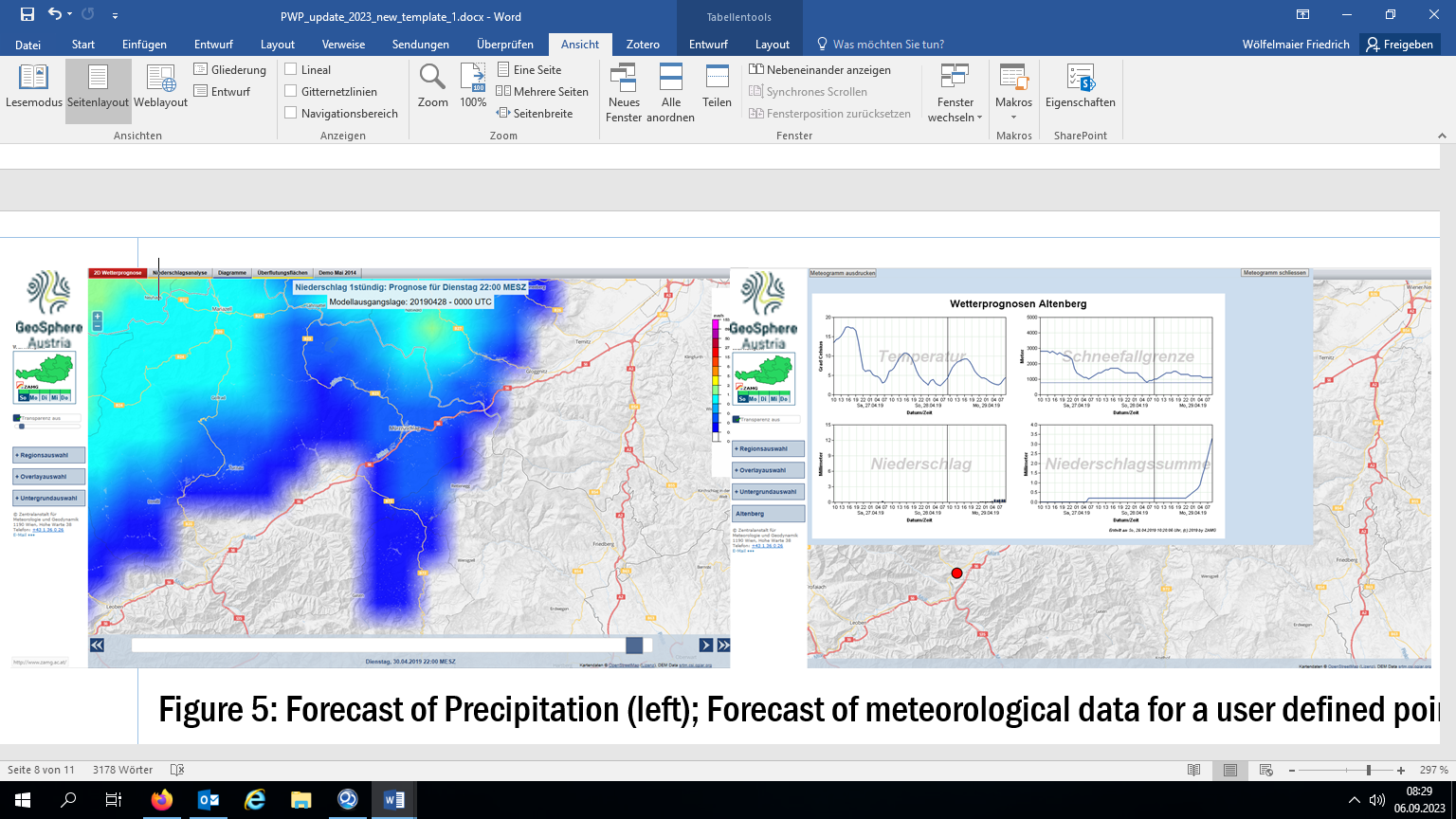
Figure 5 (left) shows the forecast of precipitation at a certain time. Furthermore, the meteorological modelling results provide, point information of temperature, precipitation, accumulated precipitation and the snow line. Meteorological information is available in the form of time series plots and is visualized in Figure 5 (right).
Discharge forecast and warning
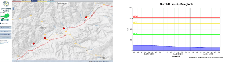
Discharge information in the river is available for a period of 24 hours. The update cycle is 1 hour within the pilot catchments, but can be increased to 4x/hour. Similarly to the point information of the meteorological data, users are able to define points of interest within the river for which the discharge is extracted. Figure 6 (left) shows an overview of user points in the Muerz river and Figure 6 (right) shows the discharge time series of one of these points.
2D floodplain forecast and warning
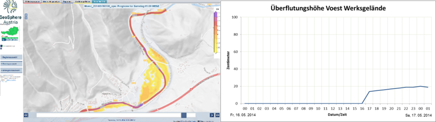
Besides meteorological and hydrological forecasts, EFFORS offers 24-hour forecasts of hydrodynamic information in flood plains. EFFORS provides contour plots of water depth with a temporal resolution of 1 hour. Additionally, users can define points of interest within the computational domain and receive a forecast of the water depth at that specific point. A threshold for the water depth can be set. At exceedance the responsible authority receives an SMS message. Another valuable information of the 2D results is to know where the river will first flood the foreland. This information allows efficient use of manpower in case of flood events. Figure 7 (left) shows the simulation results of a historical flood event within the EFFORS web portal. Information of water depth of the operational 2D model at a defined user point is shown in Figure 7 (right).
Space Added Value
The System is based on two space assets:
-
SATCOM: ensuring quasi real time data communication in critical situations (floods) and in remote areas.
-
EARTH OBSERVATION: for improved land use and land cover information.
Earth observation: Land use and cover data serve as input for the hydraulic and hydrological model to calculate parameters for retention capacity, roughness evaporation, rooting depth etc. Depending on the model used, mono-temporal or multi-temporal EO information (e.g. on spring, summer and autumn) serves as an input for land use/cover classification. These satellite EO from ESA SENTINEL-2 are new additions to the system to obtain actual land use and land cover classification data with sufficient resolution.
Satellite communication: Satellite communication is used to transmit the sensor data in near real time to the data processing center. Satellite communication is not affected by events like floodwater, storms or avalanches. To reduce the costs thresholds are implemented so that satellite communication becomes active only when measured parameters overcome the defined thresholds.
For catchments with sensors in remote areas without terrestrial communication, satellite communication is the only way to transmit data to the processing center. Outside central and western Europe, the GSM coverage can often be patchy, therefore Satcom is more competitive.
Current Status
After the successful finalization of the feasibility study, the EFFORS flood forecasting system has been developed during the demonstration phase starting in April 2017.
The project goals and the flood forecast system has been presented to targeted users/ customers including hydropower plant operators, transport network operators, large industrial companies and communities.
The final user requirements have been defined and a customer feedback about the economic benefit of the enhanced flood forecast was analysed.
Starting from the user requirements the system requirements have been derived to satisfy the needs of the users. Hard- and software requirements of the system have been defined and transformed into detailed technical requirements of the system.
The business analysis has been updated with customer information about the benefit of the new system.
Plans have been developed for the utilization of the pre-operational service by the users during the demonstration phase and the operational service during the operational phase.
Since May 2018, the EFFORS heavy rain warning system has been running operationally for customers in two catchment areas of Austria.
After the successful model coupling of the meteorological – hydrological - hydraulic model, the system is now producing an operational 24 hour forecast of discharge, water level and floodplain for the catchments of Muerztal (Austria), Kainachtal (Austria) and Berchtesgaden (Germany) every hour. During the demonstration phase customers in these catchments have received selected information and warnings via email, SMS or web portal for free.
The pilot users and customers in the three pilot areas could test and verify the flood forecasting service. The customers with the highest interest in a forecast were located in areas with significant flood risk, in the main valley of the pilot catchments or its branches.
During the pilot workshop in Altenberg a.d. Rax the major of the community Stanz, a sub-catchment of the Muerz pilot area asked the EFFORS consortium to contribute to a flood protection project where structural flood protection measures are combined with a flood forecasting system. In this case the hydrological model wflow (DELTARES) is used in the model chain. Additional station observations for precititation and river discharge are used for data assimilation to improve the start conditions of the hydrological model runs.
For very small catchments heavy rain warnings have been offered to various communities in the pilot areas. The communities Baernbach and Mooskirchen in the Kainach catchment ordered these warnings for the summer months of 2019 and the following years.
The Demonstration Project was completed successfully and the Final Review was held in November 2019.
Prime Contractor(s)

Subcontractor(s)