Objectives of the service
UrbanAware is the leading CBRNe / HazMat Incident Modelling Platform developed by Riskaware to provide lifesaving CBRNe/HazMat situational awareness and decision support.
Key Features Include:
- Shared situational awareness and decision support via desktop and mobile phone apps
- Underpinned by trusted CBRN defence hazard modelling capabilities from the UK Defence Science Technology Laboratory
- Rapid deployment with near global coverage
- Secure cloud hosted or local install
- Interoperability with existing GIS systems
- Space-based data service provision
UrbanAware takes advantage of the latest developments in cloud computing and Modelling and Simulation as a Service (MSaaS) to provide an innovative, affordable and highly flexible service offering which is specifically customisable and easily capable of being tailored to different user community needs and practices. Combined with the provision of flexible deployment options and pricing models, including scalable pay-as-you-go or annual subscription, it enables users to select the services, capabilities and delivery option that meets both their specific budgetary constraints and their operational/training needs.
A key UrbanAware feature is the use of space-based data assets to provide automated acquisition, fusion and updating of input data streams to enable rapid setup and deployment in almost any geographical region and adaption to dynamically changing environmental parameters. With the inclusion of urban geography, meteorology data, land usage classification, terrain height, high resolution satellite imagery and video data as well as near real-time dynamic population density and movement, this advanced data service has the potential for widespread application in emergency response, beyond just the CBRNe/Hazard domain.
Users and their needs
With the evolving threat of terrorism and the consequences of industrial accidents producing life endangering toxic materials, there is an increasing need for improved local control of CBRN incidents. Consequently, there is an increasing need for first responders, local government and other agencies, as well as commercial entities concerned with risk management and insurance to have access to the type of CBRNe IM capabilities available to the military. From a first responder and local government perspective, having immediate access to trusted and affordable CBRN information would significantly improve their situational awareness and enable more effective response strategies to be developed. From a commercial perspective, understanding the risk from potential CBRNe scenarios and planning effective mitigation strategies is a vital part of business continuity which would be significantly enhanced with access to a CBRN IM system.
From our stakeholder engagement, it was evident that the majority of user groups have a need for greater situational awareness when dealing with CBRN incidents. In particular, the ability to rapidly and reliably predict and share information relating to the spread and hazardous effects of an airborne CBRN material over time was seen as being of the upmost priority in terms of saving lives and safeguarding response personnel. Information needs to be made available to users in the field as well as back at base and should be displayed in a form that ensures its meaning is immediately accessible to all user types but at the same time not result in information overload. Due to the wide range of different user and stakeholder groups, there is a clear need to ensure flexibility in solution offering both in terms of system architecture and deployment. Many users expressed the need for a system that would integrate with existing emergency response tools, while others required a complete end-to-end solution.
The developed service is targeted at users in the UK, EU and NATO countries.
Service/ system concept
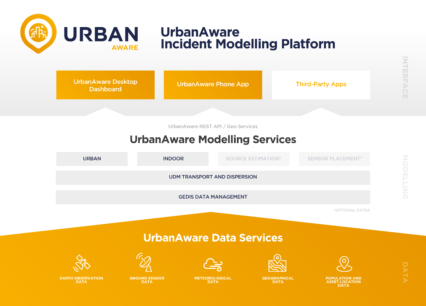
The primary operational concept of UrbanAware is that of an Information Management system that delivers shared situational awareness and decision support within the context of an unfolding CBRN/HazMat incident. While the system is designed to be flexible in terms of its deployment, the primary offering consists of a centralised modelling and information fusion service suite, providing dispersion modelling, information fusion and hazard forecasting, supported by a Consolidated Base Data Service, accessible via a desktop web app and first responders’ handheld platforms. The system also functions as a shared workspace in which a team or multiple teams operating within the context of an incident share situational information and access services that build their understanding of the unfolding situation, providing actionable information in a readily assimilable form.
Within this overall vision, three key headline services have been identified, all of which are provided within an overarching, primarily cloud-hosted system, delivered via web-based user interfaces accessible via desktop and handheld devices. Two additional supporting services provide coupling with operational workflows and with available data sources. The key headline services delivered within the initial offering are Dispersion Modelling, Information Fusion and Hazard Modelling and Definition of Key Population Risks. Within UrbanAware’s flexible framework, these could be augmented by further services, all delivered within the common service architecture as shown in Figure 1 below.
Some of the key aspects of the system vision are outlined below. The descriptions also make initial reference to areas where the proposed feasibility study will help to refine understanding of the system architecture:
- Cloud Hosted Service-Oriented System
- Common Work Area
- Common Algorithm and Modelling Integration Architecture
- Data Fusion Algorithms
- Common Data Architecture
- Space Based Data Service Provision
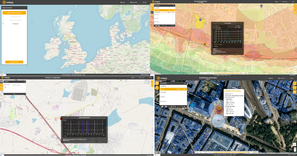
Screenshots of the capability are provided in Figure 2.
Space Added Value
It is clear that the range of modelling and decision support algorithms proposed will require significant amounts of input data in order to provide actionable information. A key element of our concept is to make extensive use of both existing and emerging space-based data throughout our partnerships with Thales Alenia Space and 4EI. The system architecture concept includes a space-based data service that collates and cleans relevant space-based data that can be accessible through a space-based data server application programming interface (API). Although this concept is focused at providing data for the CBRN IM capability, the space-based data service is also applicable to other types of user and could be offered as a service independent of the CBRNe Information management system.
The capability shown in Figure 2, and developed as part of this project utilises the following EO data sources:
- Copernicus Urban Atlas data: https://land.copernicus.eu/local/urban-atlas/urban-atlas-2012
- Copernicus Building Height: https://land.copernicus.eu/local/urban-atlas/building-height-2012
- WorldPop Gridded population: https://www.worldpop.org/focus_areas
- AIRBUS Satellite Imagery: https://www.intelligence-airbusds.com/
To support the additional aim and to provide ease of integration, where possible the space-based data will comply with common data standards such as OGC (Open Geospatial Consortium), NetCDF (Network Common Data Form), etc.
Current Status
The EuroSIM CBRN Demonstration Project is now complete following the Final Review on the 26th November 2021.Riskaware continue to engage with stakeholders and prospective customers to market and sell the UrbanAware capability. Riskaware is also working with strategic partners and resellers to improve scaleability and to provide global market reach for the UrbanAware product offering.

Prime Contractor(s)
Subcontractor(s)