

Objectives of the service
Current marine mammal protection measures rely heavily on passive acoustic detections, often leading to precautionary large-scale area closures for shipping and fishing that cause significant economic disruption. Users, including regulators and conservation groups, need faster, more accurate methods to confirm whale presence and reduce unnecessary restrictions. Marble Aerospace provides a rapid-response monitoring service using high-speed drones equipped with optimised electro-optical and infrared sensors, satellite navigation, and satellite communication links. This service delivers near real-time visual confirmation of endangered whale presence offshore, allowing for more targeted, shorter-duration closures that protect species without excessive economic costs. The project develops and validates this service through stakeholder engagement, technical testing, and operational pilots in challenging coastal and Arctic conditions. By providing reliable whale detection and integrating with existing tools like acoustic gliders, the service supports dynamic, evidence-based area management. The overall aim is to demonstrate that large marine mammal monitoring can be delivered cost-effectively at scale, creating trust among regulators, fisheries, and port operators while strengthening conservation outcomes.

Users and their needs
The primary users targeted are governmental regulators, fisheries authorities, port managers, and conservation organisations focused on protecting endangered marine mammals, especially the North Atlantic right whale. Current stakeholders engaged include WhaleSeeker (Canada), the Bedford Institute of Oceanography (Canada), and environmental research bodies in Greenland. These users require cost-effective, real-time confirmation of whale presence to avoid unnecessary broad area closures that disrupt fishing and shipping operations.
Key needs include:
-
Rapid-response aerial monitoring integrated with existing acoustic glider detections
-
Reliable operation in harsh offshore and Arctic conditions
-
High-resolution imagery to detect whales with low false positives
-
Real-time data transmission offshore, where cellular networks are limited
-
Regulatory compliance for Beyond Visual Line of Sight operations
The main challenge for the project is delivering robust technical performance in remote and weather-exposed marine environments while ensuring data is trusted and operationally useful for immediate management decisions.
Service/ system concept
The service delivers near real-time visual confirmation of whale presence offshore, helping users manage dynamic area closures more accurately. When an underwater glider detects possible whale vocalisations, a high-speed drone is launched to visually check the area. The drone uses advanced cameras and sensors to spot whales on the surface, then transmits the images and location details directly to a cloud-based platform.
Users receive clear, geo-tagged images and alerts within minutes, supporting faster decisions about where to close or reopen fishing grounds or adjust vessel routes. The drones operate even in challenging weather and can launch from coastal sites or vessels.
The system combines three main parts: the drone aircraft that collects the images, satellite navigation and satellite communication for precise positioning and data transfer, and an online platform where users access live feeds and reports. By removing the need for costly manned patrol flights and avoiding broad, precautionary closures, this service enables targeted protection of endangered whales while reducing unnecessary economic impacts.
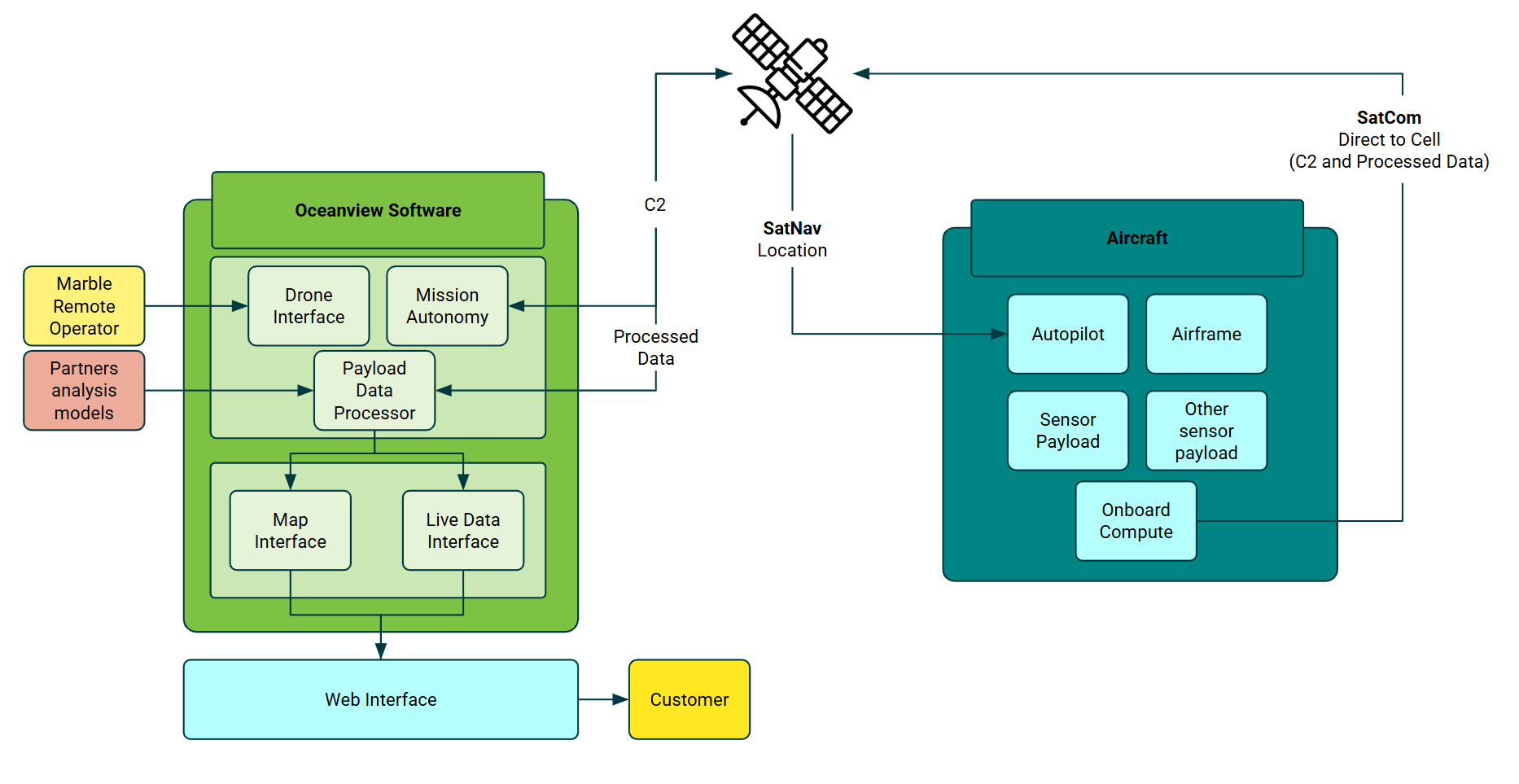
Space Added Value
The service uses three key space assets: satellite navigation, satellite communication, and satellite Earth observation as a complementary input. Satellite navigation ensures each drone operates accurately offshore and provides precise location data for whale sightings. Satellite communication, including Starlink Direct-to-Cell where available, enables reliable real-time data transmission from remote marine areas where mobile networks are weak or unavailable. Satellite Earth observation supports the system by helping identify wider areas of interest for targeted drone deployment.
Combining these space assets allows the service to deliver near-real-time, location-accurate whale confirmation at a fraction of the cost of manned patrol aircraft. Unlike traditional methods, which depend on expensive flights or coarse satellite images limited by cloud cover, the drones provide persistent, responsive monitoring that integrates with passive acoustic gliders. This hybrid approach offers users clear visual proof when whales are present, avoiding unnecessary broad closures and building trust in dynamic area management. Overall, the use of satellite-based assets expands the coverage, speed, and reliability of marine mammal monitoring far beyond what existing vessel or aircraft-based solutions can offer.
Current Status
The project has completed successful live early-stage demonstrations in the United Kingdom and Northern Ireland, proving the drone system’s performance in coastal and offshore conditions. Stakeholder engagement includes direct collaboration with WhaleSeeker, the Bedford Institute of Oceanography in Canada, and Cornwall IFCA in the UK, who helped refine operational requirements. Technical trials have validated the high-speed drone’s endurance, sensor performance, and real-time data streaming capabilities. Work is progressing on integrating Starlink Direct-to-Cell for offshore data transfer, with early hardware tests completed. Preparations are underway for Arctic deployment trials in Greenland to confirm performance in extreme conditions.
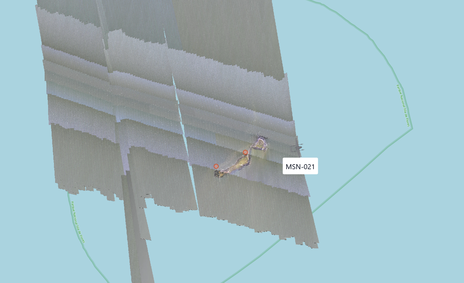
Example image of real-time data feed from the MRB5 drone to the Marble’s cloud-based Oceanview platform