Objectives of the service
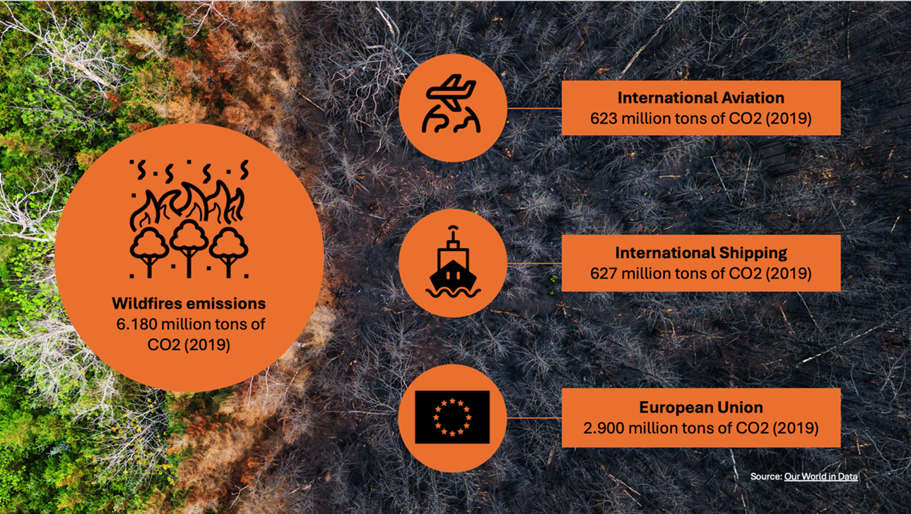
Wildfires emit 10 times the CO2 of global international aviation annually, yet outdated response methods persist, i.e., water bomber aircraft still operate very much like they were 50 years ago, and firefighters on the ground mostly have no real-time overview, relying, at best, on 24-hour-old satellite data. Firemapper aims to revolutionize wildfire management by providing real-time, scalable, and cost-efficient intelligence through advanced aerial data capture and cloud-based analytics.
Firemapper addresses the critical need for accurate, real-time wildfire monitoring and response. The service combines advanced Satellite Navigation, Earth Observation, and communication technologies and data to provide actionable intelligence to frontline responders, crisis management authorities and policymakers. By delivering high-resolution fire maps, advanced analytics, and operational coordination tools, Firemapper enhances decision-making and resource allocation during wildfire crises.
Key objectives of the service include:
-
Delivering georeferenced, real-time fire perimeter maps and intensity data.
-
Predicting fire spread and optimising suppression tactics using advanced analytics.
-
Enabling seamless data integration for collaborative wildfire mitigation efforts and policies.

Users and their needs
The Firemapper service targets a well-defined set of wildfire management stakeholders across Europe, particularly in countries like Portugal and Spain, which face frequent wildfire challenges. These user communities include:
1. Fire and Crisis Management Authorities
-
Real-time wildfire mapping for large-scale situational awareness.
-
High-resolution fire perimeter maps and intensity data.
-
Nighttime monitoring capabilities for continuous operations.
2. Firefighters and Aerial Firefighting Teams
-
Tactical, high-resolution maps for hotspot and fire jump detection.
-
Analytical tools for fire spread and tactical decision-making.
-
Real-time updates on suppression operations effectiveness.
3. Forestry Managers and Insurance Companies
-
Pre- and post-fire assessment tools for risk and damage evaluations.
-
Real-time fire tracking to protect assets and critical infrastructure.
-
Data for reforestation and recovery planning.
4. Emergency Coordinators and Policymakers
-
Operational dashboards for enhanced situational oversight and resource allocation.
-
Post-incident reports for funding decisions and policy formulation.
Key Challenges
-
Technical constraints: Reliable real-time data transmission in areas with poor connectivity.
-
Operational constraints: Aircraft availability and airspace permissions during peak wildfire seasons.
-
Environmental challenges: Data reliability under harsh wildfire conditions.
These users collectively need scalable, cost-efficient, and interoperable solutions that address real-time monitoring, resource coordination, and post-fire recovery.

Service/ system concept
Information and Capabilities Supplied to Users
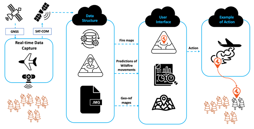
Firemapper provides real-time wildfire maps via SatCom, including fire perimeter boundaries, hotspots, and fire spread predictions. It supplies high-resolution images and updates, even during nighttime operations. The images, maps and analytics are provided through APIS to the responders’ incumbent systems, enabling:
-
Real-time decision-making support for enhanced fire suppression.
-
Coordination of aerial and ground firefighting resources.
-
Post-fire damage assessment and recovery planning.
How the System Works (Simplified)
-
Data Capture: Sensors mounted on aircraft capture heat signatures and images of wildfires.
-
Data Transmission: The captured data is sent through SatCom to a ground processing center.
-
Data Processing: Advanced software analyses the data to generate fire perimeter maps and analytics.
-
Delivery to Users: The processed information is sent via APIs to the responders’ operations systems.
The operations model and carrier-agnostic systems leverage standard aircraft already in operation in wildfire-prone areas, making it cost-effective and swift to deploy globally.

Space Added Value
The Firemapper system integrates satellite-based assets, particularly for real-time communication and positioning services, ensuring seamless delivery of critical wildfire information. The key space assets include:
-
Satellite Communication (SatCom): Used to transmit real-time wildfire data from aircraft to ground centres, overcoming limitations of terrestrial networks in remote areas.
-
Global Navigation Satellite Systems (GNSS): Provide precise positioning and georeferencing of captured fire data, enabling accurate mapping of fire perimeters, hotspots, and resource locations.
Added Value Over Current Methods:
-
Real-time Communication: Unlike current systems that rely on ground infrastructure, SatCom ensures uninterrupted data flow even in areas without connectivity.
-
Precision and Accuracy: GNSS ensures georeferenced data delivery, offering pinpoint accuracy for fire perimeter mapping and resource deployment.
-
Scalability: Space assets enable wide-scale deployment across regions, overcoming geographic and resource limitations faced by competitors.
-
Cost Efficiency: Space-based communication and GNSS lower costs by reducing reliance on expensive terrestrial infrastructure.
By integrating SatCom and GNSS, Firemapper delivers a faster, more precise, and scalable solution for wildfire monitoring and response, significantly improving upon existing methods that suffer from connectivity and accuracy limitations.
Current Status
The Firemapper kickstart activity has progressed swiftly, with several key milestones achieved:
-
User Engagement: Extensive rounds of user interviews were conducted with stakeholders from Portugal, France, Greece, and Spain, including firefighting authorities, emergency coordinators, and forestry managers.
-
User Needs Identified: Critical needs, such as real-time fire perimeter mapping, nighttime monitoring, and data integration via APIs, have been validated through interviews and feedback sessions.
-
Technical Development: The System Service Architecture has been finalized, and the Firemapper project is ready to commence system development.
Ongoing Work:
-
Initial pretotyping has begun, and field-testing of real-time fire mapping capabilities is underway.
-
Refinement of data processing workflows to ensure the rapid delivery of actionable insights.
-
The ESA Kick-Start project ended in January 2025 and Firemapper is currently preparing for a demonstration project as a next step.
Upcoming Activities (2025):
-
Development of in-house mission planning software aligned with the System Service Architecture
-
Development in partnership of real-time tactical analytics using AI and ML processes.
-
Large-scale demonstrations for undergrowth biomass identification utilizing EO data from Sentinel-1 and -2.
-
Continued collaboration with industry stakeholders and partners to optimize system impact and market fit.


